Skip to search
Skip to main content
Skip to first result
Yale University Library
Ask Yale Library
Reserve Rooms
Places to Study
Research
Quicksearch
Search Library Catalog (Orbis)
Search Law Library Catalog (MORRIS)
Search Borrow Direct
Search WorldCat
Search Articles+
Search Digital Collections
Search Archives at Yale
Research Guides
Find Databases by Title
Find eJournals by Title
Guide to Using Special Collections
Services
Your Personal Librarian
Subject Specialists
Research Support and Workshops
Citation Tools
OverDrive: Popular Audio and eBooks
Get It @ Yale (Borrow Direct, Interlibrary Loan, Scan & Deliver)
Course Reserves
Off-Campus Access
EliScholar
OverDrive: Popular Audio and eBooks
Bass Media Equipment
Libraries & Collections
Arts Library
Bass Library
Beinecke Library
Classics Library
Divinity Library
Film Study Center
Fortunoff Archive
Humanities Collections
International Collections
Law Library
Lewis Walpole Library
Library Collection Services
Manuscripts & Archives
Map Collection
Marx Science & Social Science Library
Medical Library
Music Library
Sterling Library
Yale Center for British Art
Information & Policies
Library Hours
Departments & Staff
Borrowing & Circulation
Services for Persons with Disabilities
Copyright Basics
Scanning, Printing & Copying
Computers & Wireless
Library Policies
About the Library
Giving to the Library
Purchase Request
Working at the Library
Terms Governing Use of Materials
Search in
All Fields
Creator
Title
Call Number
Date
Subject
Orbis ID
Full Text
Description
Full text
search for
Search
Search
Advanced Search
Digital Collections
Search
You Searched For
Extent of Digitization
Completely digitized
Access
Public
Repository
Beinecke Rare Book and Manuscript Library
Publication Place
[London] :
New Search
« Previous
|
1
-
99
of
365
|
Next »
Sort
by relevance
relevance
Creator (A --> Z)
Creator (Z --> A)
Title (A --> Z)
Title (Z --> A)
Year (ascending)
Year (descending)
Number of results to display per page
99
per page
9
per page
30
per page
60
per page
99
per page
View results as:
List
List
Gallery
Gallery
Search Results
A Discription of plain-dealing, time, and death, which all men ought to mind whilst they do live on
A Map of the most inhabited part of New England [cartographic material] : containing the provinces
A New & Correct Plan of the Cities of London and Westminister, with the Borough of Southwark ...
A Prospective view of the battle fought near Lake George, on the 8th of Sepr. 1755 : between 2000
A catalogue of the valuable library of Mr. Josiah Colebrook, deceased : F.R.S. and late treasurer
A chart of North and South America : including the Atlantic and Pacific Oceans, with the nearest
A contracted scetch of the plan of London &c. : printed on 24 sheets of imperial paper, to shew the
A counciller [graphic] / Rowlandson.
A description of East India : conteyning the Empire of the Great Mogoll / R. Elstracke sculpsit.
A dialogue between Bowman the Tory, and Prance the runagado : a new song.
A general map of North America ; from the latest observations / engrav'd by Jno. Lodge from the
A general map of the middle British colonies in America : viz. Virginia, Maryland, Delaware
A mad dog in a coffee house [graphic] / J. Nixon Esqr. delin ; Rowlandson scul.
A map of Cumberland ... Engraved by J. Cary.
A map of Hartfordshire.
A map of Lancashire ... Engraved by J. Cary.
A map of Maryland with the Delaware counties and the southern part of New Jersey &c / [cartographic
A map of Middlesex.
A map of New England and New York / F. Lamb sculp.
A map of New Scotland with its dependencies and a succint account of the country.
A map of North America and the West Indies / by L.S. de la Rochette.
A map of Oxfordshire... Heywood Delt. Sudlow fc.
A map of Paradise mount Ararat and the city of Babel : according to the three different hypotheses
A map of Philadelphia and parts adjacent / by N. Scull and G. Heap.
A map of Turky [sic] Arabia & Persia : corrected from the latest travels and from the observations
A map of Virginia and Maryland / F. Lamb sculp.
A map of Westmoreland ... Engraved by J. Cary.
A map of old & new Castile : from the observations of Rodrigo Mendes Silva and others.
A map of the British and French settlements in North America / T. Bowen, sculpt.
A map of the North Pole : with all the territories that lye near it, known to us &c. : according to
A map of the River Gambra from Eropina to Barrakunda / by Captn. John Leach in 1732 ; Thos. Kitchin
A map of the West Indies or the Islands of America ... explaining what belongs to Spain, England
A map of the World Corrected from the observations communicated to the Royal Societys of London and
A map of the colony of Rhode Island [cartographic material] : with the adjacent parts of
A map of the county of Flanders / [cartographic material] / by William de l'Isle ...
A map of the eastern part of the Province of New York : with part of New Jersey &c. / drawn from
A map of the kingdom of Ireland : divided into provinces, counties and baronies, shewing the
A map of the most inhabited part of New England : containing the provinces of Massachusetts Bay and
A map of the provostship and vicounty of Paris [cartographic material] : drawn from a great number
A map of the states of Virginia, North Carolina, South Carolina and Georgia [cartographic material
A map of the terrestrial Paradise according to Mr. Huet / with improvements from Dr. Wells.
A new & accurate map of China : drawn from surveys made by the Jesuit Missionaries, by order of the
A new & accurate map of Negroland and the adjacent countries : also Upper Guinea, shewing the
A new and Exact map of France ... H. Moll Geographer.
A new and Exact map of Spanish & Portugal ... H. Moll, Geographer.
A new and accurat map of the world : drawne according to ye truest descriptions, latest discoueries
A new and accurate Map of Warwickshire ... by Thos. Kitchin, Geographer.
A new and accurate map of New Jersey, Pensilvania, New York and New England, with adjacent
A new and accurate map of North America, (wherein the errors of all preceding British, French, and
A new and accurate map of the English empire in North America : representing their rightful claim
A new and accvrat map of the world : drawne according to ye truest descriptions, latest discoveries
A new and correct map of the world laid down according to the newest discoveries, and from the most
A new and exact map of the dominions of the King of Great Britain on ye continent of North America
A new chart of the coast of Norway Christiansund to Stadtland ... Engraved by W.R. Pearcey.
A new description of Carolina / Francis Lamb sculp.
A new improved map of Oxfordshire ... By Thos. Kitchin Geographer.
A new map of Denmark and Sweden ... H. Moll. Geographer.
A new map of Great Britain : corrected from the observations communicated to the Royal Society at
A new map of Ireland ... Herman Moll, Geographer 1714.
A new map of Italy ... post roads ... / H. Moll, geographer.
A new map of Italy : distinguishing all the sovereignties in it, whether states, kingdoms, dutchies
A new map of North America, with the West India Islands : divided according to the preliminary
A new map of Upper & Lower Canada [cartographic material].
A new map of the British Empire in Nth. America / drawn from the latest authorities by Thos
A new map of the north parts of America claimed by France under ye names of Louisiana, Mississipi
A new play called Canterburie his change of diot : which sheweth variety of wit and mirth
A new-years guift to the templers : on that eminent lawyer Sir Edmond Saunders, his being chosen
A plan of St. Philips Castle on the island of Minorca : with its fortifications & the entrance of
A plan of the City of New York and its environs ... John Montresor Engineer.
A plan of the city and fortifications of Louisburg / from a survey made by Richard Gridley, Lieut
A plan of the city of Canton on the river Ta ho [cartographic material].
A plan of the town of Boston, with the intrechments &c. of His Majestys Forces in 1775: from the
A sketch of the North of Sweden, of Norway, Finland, and Lapland. Describing the rout of J. Acerbis
A trew and exact mapp of Germany ... after N. Vischer and others.
A true relation of the life and death of Sir Andrew Barton : a pyrate and rover on the seas : tune
Abissinorum Regnu[m].
Advice to the city : sung to the King at Windsor, to a theorbo.
Africa [cartographic material] / drawn from the best maps by T. Jefferys, Geographer to his Royal
Africa road map 1:2,000,000 and 1:500,000, Maroc-Algerie-Tunisie.
Alsace-Lorraine.
America with those known parts in that unknowne worlde both people and manner of buildings
Americae descriptio nova / Will. Trevethen, sculp.
An accurate map of Buckingham Shire divided into its hundreds : drawn from the best authorities
An accurate map of Kalbar River (commonly called Kalabar or Rio Real) and adjacent coast drawn on
PREVIOUS
«
1
2
3
4
»
NEXT
Limit your search
Extent of Digitization
Completely digitized
✖
[remove]
365
Access
Public
✖
[remove]
365
Repository
Beinecke Rare Book and Manuscript Library
✖
[remove]
365
Format
cartographic
304
text
51
still image
7
notated music
2
mixed material
1
Genre
Maps
276
Broadside poems
41
Maps.
17
Nautical charts
6
Topographic maps
5
woodcuts (AAT)
5
Devotional literature
4
Early works
4
illustrations (AAT)
4
Annotations (Provenance)--20th century
3
more
Genre
»
Resource Type
Maps, Atlases & Globes
304
Books, Journals & Pamphlets
6
Music (Printed & Manuscript)
2
Prints & Photographs
1
Language
English
309
Latin
8
French
6
Spanish; Castilian
1
Swedish
1
Creator
Great Britain. War Office. General Staff. Geographical Section
22
Royal Geographical Society (Great Britain)
10
Moll, Herman, -1732
8
Speed, John, 1552?-1629
8
Great Britain. Inter-service Topographical Dept
7
L'Isle, Guillaume de, 1675-1726
7
Great Britain. War Office. General Staff. Topographical Section
5
Jefferys, Thomas, d. 1771
5
Kitchin, Thomas, d. 1784
5
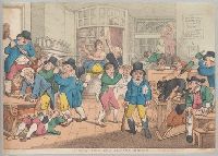
Rowlandson, Thomas, 1756-1827, printmaker.
4
more
Creator
»
Subject (Topic)
Brit tracts--1683
8
Brit tracts--1685
5
Brit Tracts--1682
4
Brit tracts--1684
4
British--America--Maps--Early works to 1800
4
Ethnology--Balkan Peninsula--Maps
4
Ethnology--Europe, Central--Maps
4
Population density--Europe, Central--Maps
4
Brit Tracts--1670
3
Brit Tracts--1681
3
more
Subject (Topic)
»
Subject (Name)
Royal Geographical Society (Great Britain)
15
Great Britain. War Office. General Staff. Geographical Section
8
Sayer, Robert, 1725-1794
7
Senex, John, d. 1740. New general atlas
6
Auchincloss, Hugh Dudley--Ownership.
5
Harvey, Francis--Ownership.
5
J. & C. Walker (Firm), engraver
5
Bassett, Thomas, bookseller
4
Bingham, Hiram,--1831-1908.--Ownership
4
Bowles, John, 1701-1779
4
more
Subject (Name)
»
Publication Place
[London] :
✖
[remove]
365
Washington, D.C. :
10
[Edinburgh] :
1
Date Created
View distribution
Current results range from
1535
to
1945
Date Created range begin
Date Created range end
View larger »