Des Barres, Joseph F. W. (Joseph Frederick Wallet), 1722-1824
Published / Created:
Feb. 1st, 1781.
Call Number:
732 L58 1781
Container / Volume:
BRBL_00376A
Image Count:
1
Resource Type:
Maps, Atlases & Globes
Description:
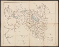
Appears in the author's Atlantic neptune., Has watermark., In top right margin: Pl. 14., Includes text., and Relief shown by hachures and shading. Depths shown by soundings.
Publisher:
J.F.W. Des Barres,
Subject (Geographic):
Liverpool Bay (N.S.)--Maps--Early works to 1800
Subject (Name):
Des Barres, Joseph F. W. (Joseph Frederick Wallet), 1722-1824. Atlantic neptune
Subject (Topic):
Harbors--Nova Scotia--Liverpool Bay--Maps--Early works to 1800
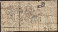
"Alphabetical list of 300 principal streets.", Inset: An enlarged plan of the rules of the Fleet prison. 100 yards to 3/4 inch., and Preliminary record.
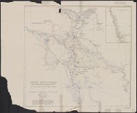
"This map is taken from that given in the portfolio of "Plans of the irrigation of Mesopotamia" (no. 2) by Sir Wm. Willcocks ...", From the papers of Oscar Terry Crosby., In lower right corner: Lower Mesopotamia--Willcocks., and In upper right margin: Geographic
Publisher:
Royal Geographical Society,
Subject (Geographic):
Iraq--Maps
Subject (Name):
Crosby, Oscar Terry, 1861-1947 and Royal Geographical Society (Great Britain)
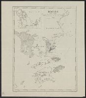
Date below publisher statement erased. Date inferred from listing on p. 113 of Phillips, Maps of America, as map 57 in Wyld's New general atlas. [1854], Library's copy stamped on verso: Yale University Library, Karpinski-Von Wieser Map Collection., and Prime me
Publisher:
James Wyld, geographer to Her Majesty, Charing Cross East,