Search
You Searched For
Search Results
- Published / Created:
- 1908
- Call Number:
- 651 1908
- Container / Volume:
- BRBL_00342
- Image Count:
- 1
- Resource Type:
- Maps, Atlases & Globes
- Found in:
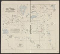
- Beinecke Rare Book and Manuscript Library > Part of north Angola : illustrating the journeys of Rev. Thomas Lewis, B.M.S., from 1899 to 1907.
- Creator:
- Royal Geographical Society (Great Britain)
- Published / Created:
- 1907
- Call Number:
- 65 1907
- Container / Volume:
- BRBL_00341
- Image Count:
- 1
- Resource Type:
- Maps, Atlases & Globes
- Found in:
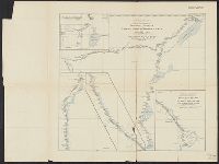
- Beinecke Rare Book and Manuscript Library > Central Africa. Route of the Alexander-Gosling expedition from the River Niger to the Red Sea, 1904-7 [cartographic material].
- Creator:
- Royal Geographical Society (Great Britain)
- Published / Created:
- 1909
- Call Number:
- 654 1909
- Container / Volume:
- BRBL_00344
- Image Count:
- 1
- Resource Type:
- Maps, Atlases & Globes
- Found in:
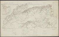
- Beinecke Rare Book and Manuscript Library > Sketch map to illustrate the journey of Hanns Vischer across the Sahara from Tripoli to Lake Chad / Geographical Journal, the Royal Geographical Society.
- Published / Created:
- 1908
- Call Number:
- 652gme 1908
- Container / Volume:
- BRBL_00343
- Image Count:
- 1
- Resource Type:
- Maps, Atlases & Globes
- Found in:
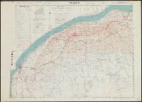
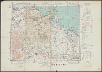
- Beinecke Rare Book and Manuscript Library > Congo State. Levels along lines of projected railways from the Upper Congo to Albert Nyanza and Tanganyika [cartographic material] / from Belgian official surveys.
- Creator:
- Great Britain. War Office. General Staff. Geographical Section
- Published / Created:
- 1942
- Call Number:
- 66gmb 1942
- Container / Volume:
- BRBL_00348
- Image Count:
- 1
- Resource Type:
- Maps, Atlases & Globes
- Found in:
- Beinecke Rare Book and Manuscript Library > Africa road map 1:2,000,000 and 1:500,000, Maroc-Algerie-Tunisie.
- Creator:
- Great Britain. Army. Royal Engineers. Field Survey Coy., 512th
- Published / Created:
- 1942
- Call Number:
- 691 B43 1942
- Container / Volume:
- BRBL_00352
- Image Count:
- 1
- Resource Type:
- Maps, Atlases & Globes
- Found in:
- Beinecke Rare Book and Manuscript Library > Bengasi, Sheet 1 / compiled, drawn, and reproduced by 512 Fd. Survey Coy., R.E., Nov., 1942.
- Creator:
- Great Britain. Army. Royal Engineers. Field Survey Coy., 512th
- Published / Created:
- 1942
- Call Number:
- 685 G11 1943
- Container / Volume:
- BRBL_00351
- Image Count:
- 1
- Resource Type:
- Maps, Atlases & Globes
- Found in:
- Beinecke Rare Book and Manuscript Library > Gabès, Sheet N.I. 32 - S.E. / .
- Creator:
- Senex, John, -1740
- Published / Created:
- [between 1750 and 1769?]
- Call Number:
- 71 1755B
- Container / Volume:
- BRBL_00363
- Image Count:
- 1
- Resource Type:
- Maps, Atlases & Globes
- Found in:
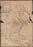
- Beinecke Rare Book and Manuscript Library > North America : corrected from the observations communicated to the Royal Society at London and the Royal Academy at Paris / by John Senex F.R.S., 1710.
- Creator:
- Wyld, James, 1812-1887
- Published / Created:
- [1854?]
- Call Number:
- 70 1854
- Container / Volume:
- BRBL_00359
- Image Count:
- 1
- Resource Type:
- Maps, Atlases & Globes
- Found in:
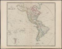
- Beinecke Rare Book and Manuscript Library > Map of America.
- Creator:
- Moll, Herman, -1732
- Published / Created:
- 1720
- Call Number:
- 71 1720C
- Container / Volume:
- BRBL_00361
- Image Count:
- 1
- Resource Type:
- Maps, Atlases & Globes
- Found in:
- Beinecke Rare Book and Manuscript Library > A new map of the north parts of America claimed by France under ye names of Louisiana, Mississipi, Canada and New France with ye adjoyning territories of England and Spain ... : the projection of this map is call'd Mercator's, and it is laid down accordin