La Pérouse, Jean-François de Galaup, comte de, 1741-1788
Published / Created:
1798
Call Number:
23 1798A
Container / Volume:
BRBL_00019
Image Count:
1
Resource Type:
Maps, Atlases & Globes
Alternative Title:
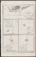
Part of the Island of Botol, Plan of Isle Dagelet, Plan of the Island Hoapinsu and the surrounding Islets, and Plan of the Island of Kumi
Description:
"No. 45.", Five maps on one sheet., From Charts and plates to La Perouse's Voyage. [London] : G.G. Robinson, 1798., Hand col. Sheet measures 42.4 x 26.5 cm., Neele, sculp., and Relief shown by spot heights, form lines, and soundings.