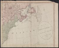
Copy 1: Stamped on verso: Yale, Horace Brown, 1900s., Includes inset of "Supplement for Hudsons and Baffins bays.", Prime meridians: London and Ferro., and Relief shown pictorially.
"Sold by Wm. Herbert on London Bridge & Robt. Sayer over against Fetter Lane in Fleet Street.", Includes inset showing North America from Hudson's Bay to Panama., Library copy shows damage in top and bottom margins., and Relief shown pictorially.
Publisher:
Sold by Wm. Herbert ...,
Subject (Geographic):
NorthAmerica--Maps--Early works to
Subject (Name):
Sayer, Robert, 1725-1794 and Society of Anti-Gallicans
Includes historical notes, text, and insets "A particular map of Baffin and Hudson's Bay" and "The passage by land to California, discover'd by Father Eusebius Francis Kino, a Jesuit; between the years 1698 and 1701, before which, and for a considerable t
Publisher:
Printed for Robt. Sayer, map, chart & printseller,
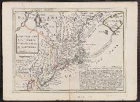
From George Henry Millar's New complete & universal system of geography. 1782., Inset map: "East Florida continued"., Recto: Numbered "166" (?) in ink ms. Verso: Stamped "Yale Horace Brown 1900S"., and Relief shown pictorially.
Publisher:
Engrav'd for Millar's New complete & universal system of geography,
Harbour of Annapolis Royal, Indian fort Sasquesahanok, and Map of ye mouth of Mississipi and Mobile rivers &c
Description:
Appears in Moll's The world described., Blocks of text offer explanations of various features of the map., Includes notes and ill. of "The Indian Fort Sasquesahanok.", Label, with ms. nos., on verso: 533/9. Hand col. Sheet measures, and Relief shown pictorially.
Publisher:
Sold by H. Moll over against Devereus Court between Temple Bar and St. Clements Church in the Strand ... [and] sold by Tho: Bowles ... Iohn King ... Iohn Bowles,
Subject (Geographic):
NorthAmerica--Maps--Early works to
Subject (Name):
Bowles, John, 1701-1779, bookseller, Bowles, Thomas, -1767, bookseller, and Moll, Herman, -1732. World described
Harbour of Annapolis Royal, Indian fort Sasquesahanok, and Map of ye mouth of Mississipi and Mobile rivers &c
Description:
Appears in Moll's The world described., Blocks of text offer explanations of various features of the map., Dedicated to Thomas Bromsall., Includes notes and ill. of "The Indian Fort Sasquesahanok.", and Insets: The harbour of Annapolis Royal -- A map of ye mouth
Publisher:
Sold by H. Moll over against Devereus Court between Temple Bar and St. Clements Church in the Strand ... [and] sold by Tho: Bowles ... Iohn King ... Iohn Bowles,
Subject (Geographic):
NorthAmerica--Maps--Early works to
Subject (Name):
Bowles, John, 1701-1779, bookseller, Bowles, Thomas, -1767, bookseller, and Moll, Herman, -1732. World described
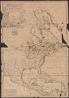
Dates inferred from similarity to variants dated c.1750 and c.1760 in Tooley's Mapping of America, p. 47 and 91., Includes text and ill., Relief shown pictorially., and Yale's copy 1 stamped on verso, "Yale, Horace Brown, 1900S." Copy 2 torn in 2 sheets, 47 x 68
Publisher:
John Bowles and Son in Cornhil :, printed for T. Bowles in St. Pauls Church yard :, and Robt. Sayer in Fleet Street,
Subject (Geographic):
NorthAmerica--Maps--Early works to
Subject (Name):
Bowles, John, 1701-1779, Bowles, Thomas, -1767, and Sayer, Robert, 1725-1794