Search
You Searched For
Search Results
- Creator:
- Allied Forces
Great Britain. War Office. General Staff. Geographical Section
- Published / Created:
- 1943-
- Call Number:
- 11hd 1942D-44
- Image Count:
- 14
- Resource Type:
- Maps, Atlases & Globes
- Found in:
- Beinecke Rare Book and Manuscript Library > Central Europe 1:100,000.
- Creator:
- Rocque, John, -1762.
- Published / Created:
- 1746
- Call Number:
- 2002 Folio 94
- Image Count:
- 16
- Resource Type:
- Maps, Atlases & Globes
- Found in:
- Beinecke Rare Book and Manuscript Library > An exact survey of the city's of London and Westminster, ye borough of Southwark and the country near ten miles round : begun in 1741, finished in 1745, and published in 1746, according to act of Parliament / by John Rocque ; engrav'd by Richard Parr and printed by W. Pratt ... = Urbium maxime insignium Londini et Westmonasterii nec non municipii Sudovercencis, regionumque ad decem quasi milliaria circumjacentium : delineatio ichnographica anno 1741 incohata 1745 absoluta / a Johanne Rocque ... = Carte topographique des villes de Londres, Westminster, et bourg de Southwark et de leurs environs : levée très exactement sur les lieux, en 1741, achevée en 1745, et publieé selon un acte de Parlement en 1746 / par Jean Rocque.
- Published / Created:
- [1738]
- Call Number:
- BrSides Folio 2017 4
- Image Count:
- 12
- Resource Type:
- Maps, Atlases & Globes
- Found in:
- Beinecke Rare Book and Manuscript Library > The first [-twelfth] sheet of Chinese Tartary ...
- Published / Created:
- 1809
- Call Number:
- 755 1809
- Container / Volume:
- BRBL_00438
- Image Count:
- 1
- Resource Type:
- Maps, Atlases & Globes
- Found in:
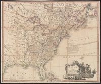
- Beinecke Rare Book and Manuscript Library > The United States of North America : with the British territories and those of Spain.
- Published / Created:
- 1776
- Call Number:
- 764 B65 1776B
- Container / Volume:
- BRBL_00455
- Image Count:
- 1
- Resource Type:
- Maps, Atlases & Globes
- Found in:
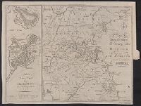
- Beinecke Rare Book and Manuscript Library > An accurate map of the country round Boston in New England ...
- Published / Created:
- 1776
- Call Number:
- 764 B65 1776B
- Container / Volume:
- BRBL_00455
- Image Count:
- 1
- Resource Type:
- Maps, Atlases & Globes
- Found in:
- Beinecke Rare Book and Manuscript Library > An accurate map of the country round Boston in New England ...
- Published / Created:
- 1777
- Call Number:
- 764 B65 1777A
- Container / Volume:
- BRBL_00455
- Image Count:
- 1
- Resource Type:
- Maps, Atlases & Globes
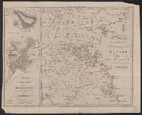
- Found in:
- Beinecke Rare Book and Manuscript Library > A plan of the town of Boston, with the intrechments &c. of His Majestys Forces in 1775: from the observations of Lieut. Page of His Majesty's Corps of Engineers: and from the plans of other Gentlemen.
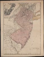
- Creator:
- Faden, William, 1749-1836
- Published / Created:
- 1778
- Call Number:
- 773 1778B
- Container / Volume:
- BRBL_00495
- Image Count:
- 1
- Resource Type:
- Maps, Atlases & Globes
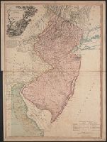
- Found in:
- Beinecke Rare Book and Manuscript Library > The province of New Jersey divided into east and west, commonly called the Jerseys / engraved ... by Wm. Faden.
- Published / Created:
- 1777
- Call Number:
- 773 1777
- Container / Volume:
- BRBL_00495
- Image Count:
- 1
- Resource Type:
- Maps, Atlases & Globes
- Found in:
- Beinecke Rare Book and Manuscript Library > The province of New Jersey divided into east and west, commonly called the Jerseys / engraved ... by Wm. Faden.
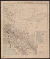
- Published / Created:
- [1910]
- Call Number:
- 97 1910
- Container / Volume:
- BRBL_00678
- Image Count:
- 1
- Resource Type:
- Maps, Atlases & Globes
- Found in:
- Beinecke Rare Book and Manuscript Library > South Peru and north Bolivia [cartographic material] : including the rubber yielding montaña.