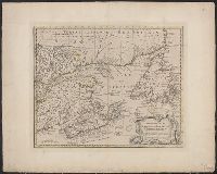
A new & accurate map of the Islands of Newfoundland, Cape Breton, St. John and Anticosta, Newfoundland, Cape Breton, St. John and Anticosta [cartographic material], and The Islands of Newfoundland, Cape Breton, St. John and Anticosta [cartographic material]
Description:
"No. 95" -- in lower right margin., Co, Hand col. Ms. note on verso: Appears as No. 63 in Bowen, E. Complete atlas, etc. London, 1752., London meridian., Relief shown pictorially., and Shows boundaries, rivers, forests, principal settlements and coastal landmarks.
Publisher:
s.n.,
Subject (Geographic):
Canada--Maps--Early works to 1800 and Maritime Provinces--Maps--Early works to 1800
A complete atlas, or distinct view of the known world., A new & accurate map of the islands of Newfoundland, Cape Breton, St. John and Anticosta., Newfoundland, Cape Breton, St. John and Anticosta [cartographic material], and The islands of Newfoundland, Cape Br
Description:
"No. 63" -- in lower left corner., From the author's A complete atlas or distinct view of the known world. 1752., Hand col. Mounted on linen. Ms. no. on recto: 61. Stamp on verso: W. Redmond Cross., Prime meridian: London., and Relief shown pictorially.