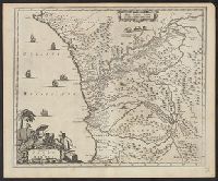
From Ogilby's Africa, being an accurate description of the regions of Egypt, Barbary, Lybia and Billedulgerid. 1670., Has watermarks., Includes ill. and decorative cartouche., Oriented with north to the left., and Relief shown pictorially.
Publisher:
Printed by T. Johnson for the author,
Subject (Geographic):
Egypt--Maps--Early works to 1800
Subject (Name):
Ogilby, John, 1600-1676. Africa, being an accurate description of the regions of Egypt, Barbary, Lybia and Billedulgerid
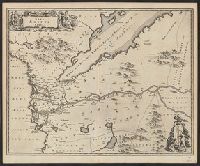
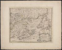
Covers coastal and interior central Africa from Port-Gen, From Ogilby's Africa, being an accurate description of the regions of Egypt, Barbary, Lybia and Billedulgerid. 1670., Has watermarks., Includes ill. and decorative cartouche., and Relief shown pictorially.
Publisher:
Printed by T. Johnson for the author,
Subject (Geographic):
Africa, Central--Maps--Early works to 1800
Subject (Name):
Ogilby, John, 1600-1676. Africa, being an accurate description of the regions of Egypt, Barbary, Lybia and Billedulgerid
Nieuhof, Johannes, 1618-1672 Ogilby, John, 1600-1676 Ogilby, John, 1600-1676. Africa, being an accurate description of the regions of Egypt, Barbary
Published / Created:
1670]
Call Number:
215 1670
Container / Volume:
BRBL_00015
Image Count:
1
Resource Type:
Maps, Atlases & Globes
Alternative Title:
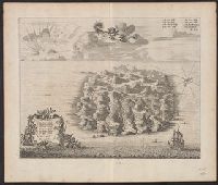
Saint Helena
Description:
Dutch and English., From Ogilby's Africa, being an accurate description of the regions of Egypt, Barbary, Lybia and Billedulgerid. 1670., Has watermarks., Includes ill. and indexes., Oriented with north toward the lower left., and Relief shown pictorially.
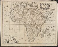
From Ogilby's Africa, being an accurate description of the regions of Egypt, Barbary, Lybia and Billedulgerid. 1670., Includes decorative title and blank dedication cartouches and ill., Relief shown pictorially., and Sheet measures 47 x 59 cm.
Publisher:
Printed by T. Johnson for the author
Subject (Geographic):
Africa--Maps--Early works to 1800
Subject (Name):
Ogilby, John, 1600-1676. Africa, being an accurate description of the regions of Egypt, Barbary, Lybia and Billedulgerid
A complete atlas, or distinct view of the known world., A new & accurate map of the islands of Newfoundland, Cape Breton, St. John and Anticosta., Newfoundland, Cape Breton, St. John and Anticosta [cartographic material], and The islands of Newfoundland, Cape Br