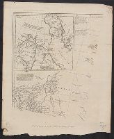
In upper right corner: Gent. Mag., Prime meridian: London., Relief shown pictorially and with hachures., Removed from: Gentleman's magazine. [June 1763]., Sheet measures 20.4 x 26.9 cm. Cross Collection no. 186., and Shows locations of North American Indian tribes.
"For Mr. Postlethwayte's Dictionary of trade & commerce.", Includes historical and descriptive notes, and an inset chart of Baffin Bay and Hudson Bay., Plates I-IV., Relief shown pictorially., and Shows provinces, cities and towns, forts, Indian villages and trib
Publisher:
H. Woodfall etc.,
Subject (Geographic):
NorthAmerica--Maps--Early works to
Subject (Name):
Anville, Jean Baptiste Bourguignon d', 1697-1782, Gravelot, H, Postlethwayt, Malachy, 1707?-1767. Universal dictionary of trade and commerce, Seale, Richard William, and Walker, Anthony, 1726-1765
Des Barres, Joseph F. W. (Joseph Frederick Wallet), 1722-1824
Published / Created:
1775?-1781?]
Call Number:
1983 Folio 25
Image Count:
3
Resource Type:
Maps, Atlases & Globes
Abstract:
A made-up collection of charts, plans and views, partly hand colored, from the Atlantic Neptune comprising [v. 1]: the charts of the South East Coast of Nova Scotia, with the title page of The charts of the coast and harbors of New England, 1781 bound in front (31 items, dated between 1777 and 1781). [v. 2]: Charts of the coast and harbours in the Gulph and river of St. Lawrence, 1780, including the charts of the coast of New England (36 items, dated between 1775 and 1781). [v. 3]: Charts of several harbours and divers parts of the coast of North America from New York south westwards to the Gulph of Mexico, 1780, including some 16 charts belonging to the New England part of the work (35 items, dated between 1776 and 1781). General title page wanting.
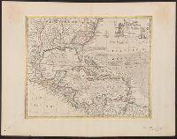
Chart of the West-Indies or the islands of America in the North Sea
Description:
"P. 734, v. 11.", Covers North and South American coastline from Albemarle Sound to the mouth of the Orinoco R., and Includes text and inset of "La Veracruz."
Publisher:
s.n., 1745?]
Subject (Geographic):
Caribbean Area--Maps--Early works to 1800 and West Indies--Maps--Early works to 1800
Map of the five Great Lakes with part of Pennsylvania, New York, Canada and Hudsons Bay territories &c.
Description:
From The London Magazine (September 1755), v. 24, p. 432., Prime meridian: London., Relief shown pictorially., and Sheet measures 22.7 x 29.4 cm. Cross Collection no. 193.
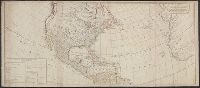
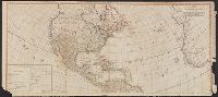
Includes table of "The continent and islands of America are divided and possessed as follows viz." and May be part of a map attributed to R. Sayer, based on maps by d'Anville and materials by Thomas Pownall; first issued in 1763 by J. Gibson and reissued over
Publisher:
s.n.,
Subject (Geographic):
NorthAmerica--Maps--Early works to
Subject (Name):
Anville, Jean Baptiste Bourguignon d', 1697-1782, Gibson, J. (John), and Pownall, Thomas, 1722-1805
Includes table of "The continent and islands of America are divided and possessed as follows viz.", Prime meridian: Ferro., and Probably part of a map attributed to R. Sayer, based on maps by d'Anville and materials by Thomas Pownall; first issued in 1763 by J.
Publisher:
s.n.,
Subject (Geographic):
NorthAmerica--Maps--Early works to
Subject (Name):
Anville, Jean Baptiste Bourguignon d', 1697-1782, Gibson, J. (John), and Pownall, Thomas, 1722-1805
"No. 57.", From Bowen's A complete system of geography ... London : Printed for W. Innys, R. Ware, Aaron Ward ..., 1747., Includes bar scale in English miles., Relief shown pictorially., Sheet measures 44.9 x 58 cm. Cross Collection no. 243., and Shows sailing tracks, currents, shoals, etc.; includes historical notes and ornamental cartouche.
Publisher:
Printed for William Innys, Richard Ware, Aaron Ward ...,
Subject (Geographic):
NorthAmerica--Maps--Early works to
Subject (Name):
Bowen, Emanuel, d. 1767. Complete system of geography