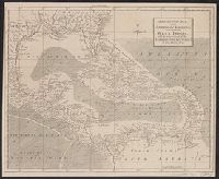
Chart of the West-Indies or the islands of America in the North Sea
Description:
"P. 734, v. 11.", Covers North and South American coastline from Albemarle Sound to the mouth of the Orinoco R., and Includes text and inset of "La Veracruz."
Publisher:
s.n., 1745?]
Subject (Geographic):
Caribbean Area--Maps--Early works to 1800 and West Indies--Maps--Early works to 1800
Subject (Topic):
Coasts--North America--Maps--Early works to 1800 and Coasts--South America--Maps--Early works to 1800
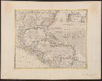
"For the London Magazine" appears above centre margin., Cross Collection no. 254., From The London magazine, v. 31, 1762, opp. p. 464., and Mounted on linen.
Publisher:
London Magazine,
Subject (Geographic):
Caribbean Area--Maps--Early works to 1800 and West Indies--Maps--Early works to 1800
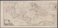
"No. 57.", From Bowen's A complete system of geography ... London : Printed for W. Innys, R. Ware, Aaron Ward ..., 1747., Includes bar scale in English miles., Relief shown pictorially., Sheet measures 44.9 x 58 cm. Cross Collection no. 243., and Shows sailing tracks, currents, shoals, etc.; includes historical notes and ornamental cartouche.
Publisher:
Printed for William Innys, Richard Ware, Aaron Ward ...,
Subject (Geographic):
Caribbean Area--Maps--Early works to 1800 and North America--Maps--Early works to 1800
Subject (Name):
Bowen, Emanuel, d. 1767. Complete system of geography
Cross Collection no., From The political magazine (March 1780), v. 1, opposite p. 179., Includes inset map: The Harbour & Fort of Omoa., Mounted on linen., and Scales in British statute miles (69 to a degree) and British marine leagues.
Publisher:
s.n.,
Subject (Geographic):
Caribbean Area--Maps--Early works to 1800, Central America--Maps--Early works to 1800, and Omoa (Cortés, Honduras)--Maps--Early works to 1800
Subject (Topic):
Harbors--Honduras--Omoa--Maps--Early works to 1800