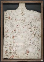
Contains five compass roses., Decoration: city views with banners, figures holding swords and armorial shields., Includes inset map of the world at lower left., Pen-and-ink in black, red, blue and green., Portolan chart with seaport names given for all coastlines., and Title devised by cataloger.
Subject (Geographic):
Black Sea--Maps--Early works to 1800., Mediterranean Sea--Maps--Early works to 1800., and North Atlantic Ocean--Maps--Early works to 1800.
Subject (Topic):
Nautical charts--Black Sea--Early works to 1800., Nautical charts--Mediterranean Sea--Early works to 1800., and Nautical charts--North Atlantic Ocean--Early works to 1800.