Skip to search
Skip to main content
Skip to first result
Search
You Searched For
Repository
Beinecke Rare Book and Manuscript Library
Format
cartographic
Language
Spanish; Castilian
Publication Place
[Mexico? :
New Search
Search Results
Creator:
Published / Created:
1885]
Call Number:
88 1885
Container / Volume:
BRBL_00646
Image Count:
6
Resource Type:
Maps, Atlases & Globes
Alternative Title:
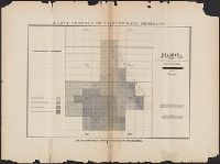
Canevas de las operaciones topográficas, region central y de oriente, fraccion inferior., Canevas de las operaciones topográficas, region central y de oriente, fraccion superior., and Canevas de las operaciones topográficas, region del norte, fraccion inferi
Description:
Diagrama que manifiesta el estado de las hojas de publicacion a la 100,000, region central y de oriente -- Diagrama que manifiesta el estado de las hojas de publicacion a la 100,000, region del norte -- Canevas de las operaciones topográficas, region central y de oriente, fraccion inferior -- Canevas de las operaciones topográficas, region del norte, fraccion superior -- Canevas de las operaciones topográficas, region del norte, fraccion inferior.
Publisher:
La Comision?,
Subject (Geographic):
Mexico--Maps
Subject (Name):
Alvarez, C. T and Diaz, A
Found in:
Beinecke Rare Book and Manuscript Library > Carta general de la Republica Mexicana / levantada por la Comision Geografico-Exploradora.
Creator:
Published / Created:
1924
Call Number:
88191 1924
Container / Volume:
BRBL_00653
Image Count:
4
Resource Type:
Maps, Atlases & Globes
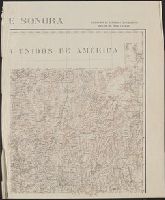
Description:
Inset: [Northwest corner of Sonora]. and Relief shown by shading and spot heights.
Publisher:
Secretaria de Agricultura y Fomento?],
Subject (Geographic):
Sonora (Mexico : State)--Maps
Subject (Name):
Dueñas, Mariano and Mexico. Dirección de Estudios Geográficos
Found in:
Beinecke Rare Book and Manuscript Library > Estado de Sonora / Secretaría de Agricultura y Fomento, Dirección de Estudios Geográficos, Sección de Cartografia, Dibujo y Zincografia ; personal de ejecución, ing. Santiago Scanlan y Mariano Dueñas.
Published / Created:
1883?]
Call Number:
883gme P11 1883
Container / Volume:
BRBL_00653
Image Count:
1
Resource Type:
Maps, Atlases & Globes
Description:
"Aprobado, Mexico, Abril 17 de 1883, Pacheco." and "V.B., Z. Talazan" and "Antonio Caso."
Publisher:
s.n.,
Subject (Topic):
Railroads--Mexico--Hidalgo (State)--Maps
Found in:
Beinecke Rare Book and Manuscript Library > Ferrocarril Hidalgo : proyecto para el ensanche de la estacion de Pachuca y alineamiento del camino que conduce á México.
Published / Created:
1895?]
Call Number:
88gme 1895
Container / Volume:
BRBL_00648
Image Count:
1
Resource Type:
Maps, Atlases & Globes
Alternative Title:
Monitor mexicano (Los Angeles, Calif. : 1895)
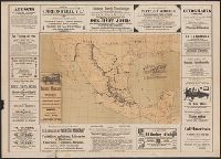
Description:
"Lit. E.M. Moreau y Hno. M." and Includes advertisements.
Publisher:
El Monitor?,
Subject (Geographic):
Mexico--Maps
Subject (Name):
E.M. Moreau y Hno
Subject (Topic):
Railroads--Mexico--Maps
Found in:
Beinecke Rare Book and Manuscript Library > Mapa de los ferrocarriles Mexicanos / propiedad de El Monitor Mexicano.
Creator:
Published / Created:
1884]
Call Number:
8819 B212 1884
Container / Volume:
BRBL_00652
Image Count:
1
Resource Type:
Maps, Atlases & Globes
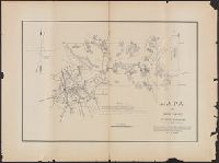
Description:
Cadastral map., Includes text., and Relief shown by form lines.
Publisher:
s.n.,
Subject (Geographic):
Balleza (Mexico)--Maps
Subject (Topic):
Real property--Mexico--Balleza--Maps
Found in:
Beinecke Rare Book and Manuscript Library > Mapa del canton Balleza, Estado de Chihuahua / levantado en el año de 1884 por el ingeniero Primitivo Saenz.
Published / Created:
1883
Call Number:
8819 C14 1883
Container / Volume:
BRBL_00652
Image Count:
1
Resource Type:
Maps, Atlases & Globes
Description:
Relief shown by form lines. and Shows various property lines.
Publisher:
s.n.],
Subject (Geographic):
Ciudad Camargo (Chihuahua, Mexico)--Maps
Subject (Name):
Wingo, A. A. Q
Subject (Topic):
Real property--Mexico--Camargo (Chihuahua)--Maps
Found in:
Beinecke Rare Book and Manuscript Library > Mapa del canton Camargo, estado de Chihuahua / ... levantado en tres copias por el ingo. civil nombrado para ello, A.A.Q. Wingo.
Creator:
Published / Created:
1852
Call Number:
883 H87 1852
Container / Volume:
BRBL_00653
Image Count:
1
Resource Type:
Maps, Atlases & Globes
Description:
Relief shown by hachures.
Publisher:
Placido Blanco?],
Subject (Geographic):
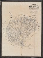
Huejutla de Reyes Region (Mexico)--Maps
Subject (Name):
Blanco, Plácido, fl. 1845-1851, Riva Palacio, Mariano, 1803-1880, and Sociedad de Geografía y Estadística del Estado de México
Found in:
Beinecke Rare Book and Manuscript Library > Mapa del distrito de Huexutla / levantado por el S.D. Tomas Ramon del Moral ; corregido por la Sociedad de Geografía y Estadística del Estado del México ; y litografiado por el C. Placido Blanco de orden del Exmo. Sr. Gobernador, D. Mariano Riva Palaci
Creator:
Published / Created:
1851
Call Number:
883 T82 1851
Container / Volume:
BRBL_00653
Image Count:
1
Resource Type:
Maps, Atlases & Globes
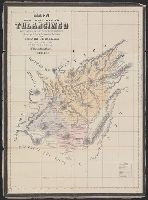
Description:
Relief shown by hachures.
Publisher:
Blanco?],
Subject (Geographic):
Tulancingo Region (Hidalgo, Mexico)--Maps
Subject (Name):
Blanco, Plácido, fl. 1845-1851, Fernandez, M., 19th cent, Riva Palacio, Mariano, 1803-1880, and Sociedad de Geografía y Estadística del Estado de México
Found in:
Beinecke Rare Book and Manuscript Library > Mapa del distrito de Tulancingo / levantado por el S. D. Tomas Ramon del Moral ; corregido por la Sociedad de Geografía y Estadística del Estado de México y litografiado por el C. Placido Blanco de orden del Exmo. Sr. Gobernador, D. Mariano Riva Palaci
Published / Created:
19--?]
Call Number:
88 M57 19XX
Container / Volume:
BRBL_00647
Image Count:
1
Resource Type:
Maps, Atlases & Globes
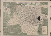
Description:
Indexed. and Library's copy imperfect: Hole in right half of map.
Publisher:
s.n.,
Subject (Geographic):
Mexico City (Mexico)--Maps
Subject (Topic):
Streets--Mexico--Mexico City--Maps
Found in:
Beinecke Rare Book and Manuscript Library > Novisimo plano de la ciudad de México con las últimas reformas de colonias nuevas y prolongación de las calles del cinco de Mayo.
Published / Created:
1896?]
Call Number:
88 Sa53 1777
Container / Volume:
BRBL_00647
Image Count:
1
Resource Type:
Maps, Atlases & Globes
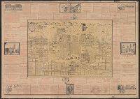
Description:
"Edición del Noveno Almanaque Potosino, años de 1895 y 1896.", Includes advertisements, ill., and index., Oriented with north toward left., Relief shown pictorially., and Reproduction of early map, used to advertise "Almanaque Potosino."
Publisher:
Edición del Noveno Almanaque Potosino?,
Subject (Geographic):
San Luis Potosí (Mexico)--Maps--Early works to 1800
Subject (Name):
Burapa, Manuel de and Vildósola, Juan Mariano
Found in:
Beinecke Rare Book and Manuscript Library > Plan orisontal de la ciudad de San Luis Potosi con todos sus pueblos y barrios, estratado G.D. Juan Mariano de Vildosola del q.e formó D. Manuel de Burapa, año 1777.
Branch:v1.64.0 ,Deployed:2024-09-11T10:25:40-04:00