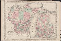
"Entered according to Act of Congress in the Year 1864, by A.J. Johnson in the Clerks Office of the District Court of the United States for the Southern District of New York.", In upper margins: 56, 57., and Includes notes on elevation, water depths, and area in square miles in selected parts of map.
Shows railroads, corporate land ownership, plats of Marquette and Negaunee, sawmill locations in all or parts of sections T.47-48 N, R. 25-27 W.
Description:
Backed with linen. Manuscript annotations on map. Manuscript title on verso: Marquette Iron Region. From the Richard H. Rickard Papers., Coordinates not present on map and are approximated., Detached from: A statement of the plan of the St. Mary's Canal Mineral Land Company (New York : Baker & Godwin, printers, 1859)., and Relief shown by hachures.
Publisher:
[Baker & Godwin, printers],
Subject (Geographic):
Michigan--Upper Peninsula
Subject (Name):
Collins Iron Company--Maps., Excelsior Iron Company--Maps., Jackson Iron Company (Fayette, Mich.)--Maps., Peninsula Iron Company--Maps., Pioneer Iron Company--Maps., and Rickard, Richard H.,---1885--Owner