Skip to search
Skip to main content
Skip to first result
Search
You Searched For
Language
English
Publication Place
[New York] :
Subject (Geographic)
United States--Maps
Search Results
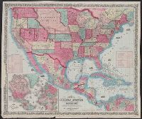
Published / Created:
1857
Call Number:
75gme 1857
Container / Volume:
BRBL_00412
Image Count:
2
Resource Type:
Maps, Atlases & Globes
Description:
Inset (separate sheet, attached to front of map): Rail Road Map of Massachusetts, Connecticut and Rhode Island, ca. 1:3,000,000.
Subject (Geographic):
United States--Maps
Found in:
Beinecke Rare Book and Manuscript Library > A new and complete Rail Road map of the United States / compiled from reliable sources by William Perris ; presented by the Home Insurance Company of New York ; Korff Brothers, Practical Lithographers, New York.
Creator:
Published / Created:
[1859]
Call Number:
75 1859
Container / Volume:
BRBL_00401
Image Count:
1
Resource Type:
Maps, Atlases & Globes
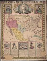
Description:
"December 1859." and Includes illustrations of ships, historical notes, "Table of Distances", and "Table showing the route of the steamers of the United States and Mexican Mail Steam Ship Line and the various ports in the Gulf of Mexico at which they are to t
Publisher:
Johnson & Browning,
Subject (Geographic):
Caribbean Area--Maps, Central America--Maps, Mexico, Gulf of--Maps, Mexico--Maps, and United States--Maps
Subject (Name):
Johnson & Browning
Subject (Topic):
Mail steamers--Mexico--Maps, Mail steamers--United States--Maps, Steamboat lines--Maps, and Trade routes--Maps
Found in:
Beinecke Rare Book and Manuscript Library > Map of the United States and Mexico / published by Johnson & Browning under the direction of Col. Carlos Butterfield.
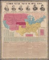
Published / Created:
1856
Call Number:
75F 1856
Container / Volume:
BRBL_00410
Image Count:
1
Resource Type:
Maps, Atlases & Globes
Description:
Accompanying covers., Decorative border., Hand colored., Political portraits at top and text at bottom of sheet., and Preliminary record.
Publisher:
A Ranny,
Subject (Geographic):
United States--Maps
Found in:
Beinecke Rare Book and Manuscript Library > National political map of the United States.
Published / Created:
1846
Call Number:
75 1846A
Container / Volume:
BRBL_00399
Image Count:
1
Resource Type:
Maps, Atlases & Globes
Description:
Hand colored. and Surrounded by star and chain border with portraits of Washington, Cortez, and Montezuma at top and portraits and text at bottom.
Publisher:
Humphrey Phelps,
Subject (Geographic):
United States--Maps
Found in:
Beinecke Rare Book and Manuscript Library > Phelps's ornamental map of the United States and Mexico.
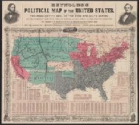
Published / Created:
1856
Call Number:
75F 1856A
Container / Volume:
BRBL_00410
Image Count:
1
Resource Type:
Maps, Atlases & Globes
Description:
Accompanying covers., Hand colored., Portraits at top of sheet., and Vine and illustrative border.
Publisher:
W.C. Reynolds,
Subject (Geographic):
United States--Maps
Found in:
Beinecke Rare Book and Manuscript Library > Reynolds's political map of the United States ... Electrotyped by Filner & Co.
Branch:v1.68.2 ,Deployed:2025-06-12T06:59:33-04:00