Search
You Searched For
Search Results
- Creator:
- American Council on Soviet Relations
- Published / Created:
- 1941]
- Call Number:
- 35 1941B
- Container / Volume:
- BRBL_00101
- Image Count:
- 2
- Resource Type:
- Maps, Atlases & Globes
- Found in:
- Beinecke Rare Book and Manuscript Library > 8th anniversary American Soviet diplomatic relations.
- Creator:
- Encyclopaedia Britannica, inc
Matthews-Northrup Works
- Published / Created:
- 1918?]
- Call Number:
- 11hc 1917R
- Container / Volume:
- BRBL_00010E
- Image Count:
- 1
- Resource Type:
- Maps, Atlases & Globes
- Found in:
- Beinecke Rare Book and Manuscript Library > A geographical and historical guide to the world's wars, 4000 B.C. to 1918 [cartographic material] : No. 1, north-western Europe, showing the "Western Front" / engraved and printed at the Matthews-Northrup Works, Buffalo, N.Y.
- Creator:
- Encyclopaedia Britannica, inc
Matthews-Northrup Works
- Published / Created:
- 1918?]
- Call Number:
- 11hc 1918J-2
- Container / Volume:
- BRBL_00010F
- Image Count:
- 1
- Resource Type:
- Maps, Atlases & Globes
- Found in:
- Beinecke Rare Book and Manuscript Library > A geographical and historical guide to the world's wars, 4000 B.C. to 1918 [cartographic material] : No. 1, north-western Europe, showing the "Western Front" / engraved and printed at the Matthews-Northrup Works, Buffalo, N.Y.
- Creator:
- Encyclopaedia Britannica, inc
Matthews-Northrup Works
- Published / Created:
- 1918?]
- Call Number:
- 11hc 1918J
- Container / Volume:
- BRBL_00010F
- Image Count:
- 1
- Resource Type:
- Maps, Atlases & Globes
- Found in:
- Beinecke Rare Book and Manuscript Library > A geographical and historical guide to the world's wars, 4000 B.C. to 1918 [cartographic material] : No. 3, Showing the Italian, Balkan and Turkish Fronts / engraved and printed at the Matthews-Northrup Works, Buffalo, N.Y.
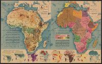
- Creator:
- Harrison, Richard Edes
- Published / Created:
- 1941
- Call Number:
- 60C 1941
- Container / Volume:
- BRBL_00329
- Image Count:
- 2
- Resource Type:
- Maps, Atlases & Globes
- Found in:
- Beinecke Rare Book and Manuscript Library > Africa in maps / Richard Edes Harrison.
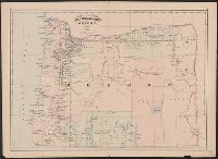
- Creator:
- Asher & Adams
- Published / Created:
- 1872?]
- Call Number:
- 846 1872
- Container / Volume:
- BRBL_00621
- Image Count:
- 1
- Resource Type:
- Maps, Atlases & Globes
- Found in:
- Beinecke Rare Book and Manuscript Library > Asher & Adams' Oregon.
- Published / Created:
- 1870
- Call Number:
- 38hc 1870B
- Image Count:
- 1
- Resource Type:
- Maps, Atlases & Globes
- Found in:
- Beinecke Rare Book and Manuscript Library > Bird's-eye view of Paris and its surroundings : looking Northward from the Heights of Sceaux.
- Published / Created:
- 1813
- Call Number:
- 769cea 1813
- Container / Volume:
- BRBL_00476
- Image Count:
- 2
- Resource Type:
- Maps, Atlases & Globes
- Found in:
- Beinecke Rare Book and Manuscript Library > Blunt's new and correct chart of Long Island Sound, from Montauk Point to Frog's Point, including Fisher's Island Sound, and Watch Hill Reef. Surveyed in 1805 by John Cahoone, Newport, and Fosdick, New London.
- Published / Created:
- 1841
- Call Number:
- 21cea 1841
- Container / Volume:
- BRBL_00016
- Image Count:
- 1
- Resource Type:
- Maps, Atlases & Globes
- Found in:
- Beinecke Rare Book and Manuscript Library > Blunt's new chart of Guayana, ... Equator to [Orinoco River] ... W. Hooker ACSA Eng.
- Creator:
- Sherman & Smith
- Published / Created:
- 1874?]
- Call Number:
- 19cea 1874
- Container / Volume:
- BRBL_00013
- Image Count:
- 1
- Resource Type:
- Maps, Atlases & Globes
- Found in:
- Beinecke Rare Book and Manuscript Library > Chart of the Antarctic continent : shewing the icy barrier attached to it, discovered by the U.S. Ex. Ex., Charles Wilkes, Esq., Commander, 1840.