Skip to search
Skip to main content
Skip to first result
Search
You Searched For
Repository
Beinecke Rare Book and Manuscript Library
Language
English
Publication Place
[New York :
New Search
Search Results
Creator:
Published / Created:
1941]
Call Number:
35 1941B
Container / Volume:
BRBL_00101
Image Count:
2
Resource Type:
Maps, Atlases & Globes
Alternative Title:
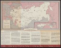
American Soviet diplomatic relations and Eighth anniversary American Soviet diplomatic relations
Description:
Panel title.
Publisher:
American Council on Soviet Relations,
Subject (Geographic):
Soviet Union--Foreign relations--1917-1945, Soviet Union--Foreign relations--United States, Soviet Union--Maps, United States--Foreign relations--1933-1945, and United States--Foreign relations--Soviet Union
Found in:
Beinecke Rare Book and Manuscript Library > 8th anniversary American Soviet diplomatic relations.
Creator:
Published / Created:
1859?]
Call Number:
BrSide4o Zc13 G7 859bg
Image Count:
2
Resource Type:
Books, Journals & Pamphlets
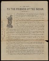
Description:
Plea to stop the persecution of Indians giving the names of organizations and magazines which supported this goal. and Signed at end: John Beeson.
Publisher:
s.n,
Subject (Name):
Beeson, John, 1803-1889--Autograph and inscription
Subject (Topic):
Indians of North America--Government relations--1789-1869
Found in:
Beinecke Rare Book and Manuscript Library > A circular to the friends of the Indian.
Creator:
Published / Created:
1918?]
Call Number:
11hc 1917R
Container / Volume:
BRBL_00010E
Image Count:
1
Resource Type:
Maps, Atlases & Globes
Alternative Title:
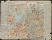
No. 1, north-western Europe, showing the "Western Front" and North-western Europe, showing the "Western Front"
Description:
"Historical notes" in left and right margins. and Inset map: The World War.
Publisher:
Encylcopaedia Britannica,
Subject (Geographic):
Europe, Western--Maps
Subject (Topic):
World War, 1914-1918--Maps
Found in:
Beinecke Rare Book and Manuscript Library > A geographical and historical guide to the world's wars, 4000 B.C. to 1918 [cartographic material] : No. 1, north-western Europe, showing the "Western Front" / engraved and printed at the Matthews-Northrup Works, Buffalo, N.Y.
Creator:
Published / Created:
1918?]
Call Number:
11hc 1918J-2
Container / Volume:
BRBL_00010F
Image Count:
1
Resource Type:
Maps, Atlases & Globes
Alternative Title:
No. 1, north-western Europe, showing the "Western Front" and North-western Europe, showing the "Western Front"
Description:
"Historical notes" in left and right margins. and Inset map: The World War.
Publisher:
Encylcopaedia Britannica,
Subject (Geographic):
Europe, Western--Maps
Subject (Topic):
World War, 1914-1918--Maps
Found in:
Beinecke Rare Book and Manuscript Library > A geographical and historical guide to the world's wars, 4000 B.C. to 1918 [cartographic material] : No. 1, north-western Europe, showing the "Western Front" / engraved and printed at the Matthews-Northrup Works, Buffalo, N.Y.
Creator:
Published / Created:
1918?]
Call Number:
11hc 1918J
Container / Volume:
BRBL_00010F
Image Count:
1
Resource Type:
Maps, Atlases & Globes
Alternative Title:
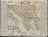
Italian, Balkan, and Turkish fronts and No. 3, Showing the Italian, Balkan and Turkish Fronts
Description:
"Historical notes" in left and right margins. and Inset map: Map showing the Turkish fronts in Armenia, Mesopotamia, and Palestine.
Publisher:
Encylcopaedia Britannica,
Subject (Geographic):
Balkan Peninsula--Maps, Europe, Eastern, Italy--Maps, and Turkey--Maps
Subject (Topic):
World War, 1914-1918--Maps
Found in:
Beinecke Rare Book and Manuscript Library > A geographical and historical guide to the world's wars, 4000 B.C. to 1918 [cartographic material] : No. 3, Showing the Italian, Balkan and Turkish Fronts / engraved and printed at the Matthews-Northrup Works, Buffalo, N.Y.
Published / Created:
1921 April
Call Number:
Za +Zt335
Collection Title:
Theatre magazine.
Image Count:
1
Description:
Monthly and Title from cover.
Publisher:
Theatre Magazine Co.],
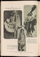
Subject (Name):
Miller, Marilyn, 1898-1936
Subject (Topic):
Theater--New York (State)--New York--Periodicals and Theater--Periodicals
Collection Created:
[New York :
Found in:
Beinecke Rare Book and Manuscript Library > A new star breaks old records
Creator:
Published / Created:
1941
Call Number:
60C 1941
Container / Volume:
BRBL_00329
Image Count:
2
Resource Type:
Maps, Atlases & Globes
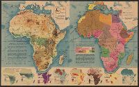
Description:
Eight inset maps (scale 1:110,000,000) show rainfall, exploration, drainage, population, races, German colonies, Islam., Physical geography -- Political complexion., Published in Fortune, Nov. 1941., and Relief shown by shading and spot heights.
Publisher:
Time, Inc.],
Subject (Geographic):
Africa--Maps
Subject (Topic):
Administrative and political divisions--Africa--Maps and Physical geography--Africa--Maps
Found in:
Beinecke Rare Book and Manuscript Library > Africa in maps / Richard Edes Harrison.
Creator:
Published / Created:
1872?]
Call Number:
846 1872
Container / Volume:
BRBL_00621
Image Count:
1
Resource Type:
Maps, Atlases & Globes
Alternative Title:
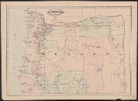
Oregon
Description:
In upper margin: 103, 104.
Publisher:
Asher & Adams,
Subject (Geographic):
Oregon--Maps
Found in:
Beinecke Rare Book and Manuscript Library > Asher & Adams' Oregon.
Published / Created:
1870
Call Number:
38hc 1870B
Image Count:
1
Resource Type:
Maps, Atlases & Globes
Description:
"Supplement to Harper's Weekly. October 8, 1870."
Publisher:
Harper & Brothers],
Subject (Geographic):
Paris Metropolitan Area (France)--Bird's-eye views
Found in:
Beinecke Rare Book and Manuscript Library > Bird's-eye view of Paris and its surroundings : looking Northward from the Heights of Sceaux.
Published / Created:
1813
Call Number:
769cea 1813
Container / Volume:
BRBL_00476
Image Count:
2
Resource Type:
Maps, Atlases & Globes
Description:
Negative photostat. and Soundings in feet, shoreline hachured; beaches stippled; rocks shown by small circles lighthouses shown in outline, tinted red by hand. New haven entrance shown just above compass rose at center of chart. Publisher's name and place of
Publisher:
Edmund M. Blunt],
Subject (Geographic):
Long Island Sound (N.Y. and Conn.)--Maps
Found in:
Beinecke Rare Book and Manuscript Library > Blunt's new and correct chart of Long Island Sound, from Montauk Point to Frog's Point, including Fisher's Island Sound, and Watch Hill Reef. Surveyed in 1805 by John Cahoone, Newport, and Fosdick, New London.
Branch:v1.61.6 ,Deployed:2024-06-12T09:55:37-04:00