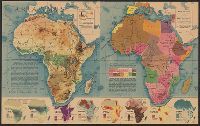
Eight inset maps (scale 1:110,000,000) show rainfall, exploration, drainage, population, races, German colonies, Islam., Physical geography -- Political complexion., Published in Fortune, Nov. 1941., and Relief shown by shading and spot heights.
Publisher:
Time, Inc.],
Subject (Geographic):
Africa--Maps
Subject (Topic):
Administrative and political divisions--Africa--Maps and Physical geography--Africa--Maps
Inset map: St. Helena. Scale [ca. 1:280,000]., Inset view: Cape Town and Table Mount., Prime meridians: Greenwich and Washington., and Relief shown by hachures.