Skip to search
Skip to main content
Skip to first result
Search
You Searched For
"United States--Maps"
Repository
Beinecke Rare Book and Manuscript Library
Publication Place
[New York :
New Search
Search Results
Published / Created:
[1848]
Call Number:
75EG 1848F
Container / Volume:
BRBL_00410
Image Count:
1
Resource Type:
Maps, Atlases & Globes
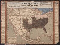
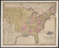
Description:
Hand-colored cerographic map with strips of paper pasted on to show relative populations in free and slave states. Shows Gila River Mexican War boundary settlement. Trials to Oregon territory are also shown.
Publisher:
John] Lewis,
Subject (Geographic):
United States --Maps
Found in:
Beinecke Rare Book and Manuscript Library > Lewis free soil map of the United States and Mexico including Oregon, Texas and the Californias.
Published / Created:
1848.]
Call Number:
75 1848U
Container / Volume:
BRBL_00399
Image Count:
1
Resource Type:
Maps, Atlases & Globes
Description:
Almost identically the same plate as that of the two Lewis maps. Cf. 75.1848F; 75.1848L. These are, Hand-colored cerographic map with Mexican War Gila River boundary settlement wrongly colored., and Railroad (proposed) and trails to Oregon Terr. are also shown.
Publisher:
Ensign & Thayer?,
Subject (Geographic):
United States --Maps
Found in:
Beinecke Rare Book and Manuscript Library > Map o f the United States and Mexico including Oregon, Texas and the Californias.
Published / Created:
1846.]
Call Number:
75 1846
Container / Volume:
BRBL_00399
Image Count:
1
Resource Type:
Maps, Atlases & Globes
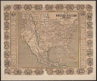
Description:
Information and the seals of thirty States decorate the border. and Preliminary record.
Publisher:
Haven & Emmerson, pubs.
Subject (Geographic):
United States --Maps
Found in:
Beinecke Rare Book and Manuscript Library > Map of the United States and Mexico Including Oregon, Texas and the Californias. By John Haven.
Published / Created:
1847?]
Call Number:
75 1847
Container / Volume:
BRBL_00399
Image Count:
1
Resource Type:
Maps, Atlases & Globes
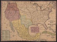
Description:
Hand colored cerographic map showing all of the United States and Mexico. Appears to have been colored after the Mexican War settlements in 1848, as the Gila River boundary is used. and Place of publication, publisher, and date taken from item 10. A. O'Brien
Publisher:
H. Phelps,
Subject (Geographic):
United States --Maps
Found in:
Beinecke Rare Book and Manuscript Library > Phelps' Ornamental map of the United States and Mexico.
Published / Created:
1856
Call Number:
75gme 1856
Container / Volume:
BRBL_00412
Image Count:
1
Resource Type:
Maps, Atlases & Globes
Publisher:
American Central Railway],
Subject (Geographic):
United States --Maps
Found in:
Beinecke Rare Book and Manuscript Library > The American Central Railway / compiled and drawn by J.W. Sylvester; Lith. of G. Hayward, N.Y.
Published / Created:
1825?]
Call Number:
75 1825G
Container / Volume:
BRBL_00398
Image Count:
2
Resource Type:
Maps, Atlases & Globes
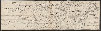
Description:
Engraved map, colored by hand to show states a, Preliminary record., and Washington & London prime meridions.
Publisher:
A.T. Goodrich & Co.,
Subject (Geographic):
United States --Maps
Found in:
Beinecke Rare Book and Manuscript Library > United States of America, compiled from the latest & best authorities by John Melish. G. Murray, Sc.
Branch:v1.61.8 ,Deployed:2024-06-20T11:14:55-04:00