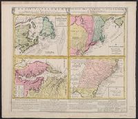
Gros-Britannische Colonie-Lænder in Nord-America, in accuraten Special-Mappen nach den London. Originalien gretreulich mitgetheilt und heraussgegeben von Homaennischen Erben
Description:
A. New Foundland od. Terra Nova, S. Laurentii Bay, die Fisch-Bank, Acadia, nebst einem Theil New Schotland -- B. New Engelland, New York, New Yersey und Pensilvania -- C. Virgin, In Latin, German and English., and Sheet measures 56 x 64 cm. Franklin Collection.
Publisher:
Homannianis Hered.,
Subject (Geographic):
Atlantic Coast (Canada)--Maps--Early works to 1800, Atlantic Coast (U.S.)--Maps--Early works to 1800, and Great Britain--Colonies--America--Maps--Early works to 1800
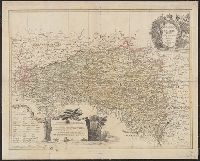
"Cum priv. Sac. Caes. Majestatis.", Backed with linen. Sheet measures 50.8 x 63.1 cm., Bar scales given in "geographische Meilen," "Roth Reussi[sche] und Pocuti[sche] Meilen," and "Hungarische Meilen.", Prime meridian: Paris., Relief shown pictorially., and Title
Publisher:
Impensis Homannianorum Haeredum,
Subject (Geographic):
Bohemia (Czech Republic)--Maps--Early works to 1800, Galicia (Poland and Ukraine)--Maps--Early works to 1800, and Ukraine--Maps--Early works to 1800
Carte general d ́Espagne et de Portugal diviseé en ses provinces actuelles par D.T. Lopez, nouvellement dressée par F.L.G. à Nuremberg chez les Heret. de Homann l ́an 1782
Description:
Bar scales given in "leguas de una hora de Camino," "leguas legales Castellanas," "leguas legales de Portugal," "leguas comunes de Francia," and "leguas geographicas ò de Alemania."
Publisher:
Edentibus Homannianis Haeredibus,
Subject (Geographic):
Portugal--Maps--Early works to 1800 and Spain--Maps--Early works to 1800
Subject (Name):
Güssefeld, F. L. (Franz Ludwig), 1744-1807 and Homann Erben (Firm)
Carte generale de la Tartarie chinoise et des royaumes de Corée et de Iapan
Description:
French alternate title only., Imperfect: western sheet (with cartouche) wanting. Sheet measures 54 x 54 cm, with watermark., Includes text and ill., and Relief shown pictorially.
Publisher:
Curis Homannianorum Heredum,
Subject (Geographic):
Chine--Divisions politiques et administratives--Cartes--Ouvrages avant 1800. and Manchuria (China)--Maps--Early works to 1800.
Subject (Name):
Anville, Jean Baptiste Bourguignon d', 1697-1782., Du Halde, J.-B. (Jean-Baptiste), 1674-1743., Gerbillon, Jean-François, 1654-1707., Homann Erben (Firm), and Mayer, Tobias, 1723-1762.
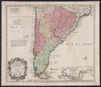
In Latin and French., Includes inset of the Straights of Magellin., Mounted on linen. Sheet measures 53.1 x 62.4 cm., Prime meridian: Ferro., and Relief shown pictorially.
Publisher:
Editoribus Homannianis Heredibus, Norib,
Subject (Geographic):
South America--Maps--Early works to 1800
Subject (Name):
Homann Erben (Firm) and Techo, Nicolás del, 1611-1685
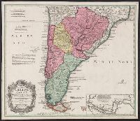
In Latin and French., Includes inset of the Straights of Magellin., Prime meridian: Ferro., Relief shown pictorially., and Sheet measures 50.6 x 58.7 cm. Blue tab pasted on left verso, with stamp "Printed in Germany."
Publisher:
Editoribus Homannianis Heredibus, Norib,
Subject (Geographic):
South America--Maps--Early works to 1800
Subject (Name):
Homann Erben (Firm) and Techo, Nicolás del, 1611-1685