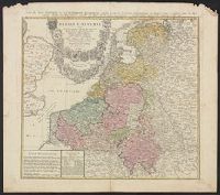
Carte des XVII. provinces ou de l'Allemagne inferievre, dresseé suivant la projection stereographique, et appüyée par les mesures faites de Mess. Cassini, Snellius et Mouschenbrok, par Mr. Tob. Majer de la Societé geographique, et publiée par les Her
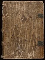
anno Domi[ni] 1400 octuagesimo t[er]cio, 18 die me[n]sis Augusti [1483]
Call Number:
2000 1552
Image Count:
7
Resource Type:
Books, Journals & Pamphlets
Alternative Title:
Vocabularius praedicantium
Description:
Contemporary ms. notes. Presentation inscription on inside of back cover to Abbot Johannes (probably Johannes Scherzwadel, abbot of Lambach from 1474-1504): Reuerendo hono[rabili]b[i] ac religiosis in [Christo] pri[ori]bus [et] fr[atr]ibus d[omi]no Johannj Abbati Andree priori totiq[ue] Couentuj Monasterii in Lambaco nob[is] semp[er] colendj., Imperfect: wormed, with slight loss of text. Leaves e1 and x10 repaired, with missing text supplied in facsimile., Imprint from colophon, supplied in facsimile in CtY-BR copy., Initials in red; rubricated throughout., Manuscript waste used in binding, including a vellum flyleaf with 92 lines of hexameter verse., Text begins on leaf a2: Si te materne remoratur inercia lingue, quo minus ad populu[m] funde[m] uerba queas ..., and Title and author from Goff.
Publisher:
Per Petrum Currificem ciue[m] Nurenbergensem,
Subject (Name):
Benedictines Austria Lambach Ownership., Klosterkirche Lambach Ownership., Scherzwadel, Johannes--Presentation inscription., and Wagner, Peter, fl. 1483-1500.
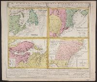
Gros-Britannische Colonie-Lænder in Nord-America, in accuraten Special-Mappen nach den London. Originalien gretreulich mitgetheilt und heraussgegeben von Homaennischen Erben
Description:
In Latin, German and English.
Publisher:
Homannianis Hered.,
Subject (Geographic):
Atlantic Coast (Canada)--Maps--Early works to 1800, Atlantic Coast (U.S.)--Maps--Early works to 1800, and Great Britain--Colonies--America--Maps--Early works to 1800
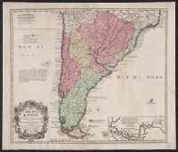
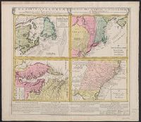
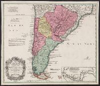
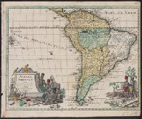
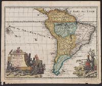
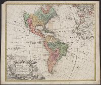
At least three states of the 1746 map exist: one state has the privilige statement "Cum Privil S.C.M." following publisher and preceding date in the cartouche, but without engraver statement "Seb. Dorn, sc." below neat line; another state has no privilege statement, but has engraver statement below neat line; and another state has no privilege statement or engraver statement, but lists "Falkland" below I. Malouines (off the southern coast of Argentia), which is missing from all other states., Relief shown pictorially., and With privilege statement in cartouche. Sheet measures 50 x 59.5 cm. Verso: "8" in ink ms. Franklin Collection.
Publisher:
In lucem proferentibus Homannianis Heredibus,
Subject (Geographic):
America--Maps--Early works to 1800 and Western Hemisphere--Maps--Early works to 1800
Subject (Name):
Boehme, August Gottlieb, 1719-1797 and Hase, Johann Matthias, 1684-1742