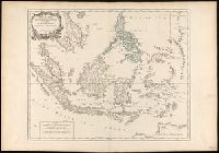
"Archipel des Indes" stamped twice on verso., Appeared in: Gilles and Didier Robert de Vaugondy, "Atlas Universel", 1753-1757 [or later]., Covers present-day Indonesia, the Philippines, Malayan peninsula, Indo-Chinese peninsula, and north-west coast of Australia., Includes inset map., Inset: Isles Marianes des Larons., Relief shown pictorially., and Watermarks.
Publisher:
[publisher not identified],
Subject (Geographic):
Southeast Asia--Maps--Early works to 1800.
Subject (Name):
Haye, G. de la, engraver., Robert de Vaugondy, Didier, 1723-1786. Atlas Universel., and Robert de Vaugondy, Gilles, 1688-1766. Atlas universel.
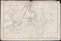
"1145 2-37"--Lower right margin., "D'après les cartes hydrographiques de la Marine française et de l'Amirauté anglais, les travaux des missions dirigées par M.M. les capitaines Montégu et Renault et les levés de M.M. les sergents Guyot et Hengoat.", "Imprimé au Service géographique de l'Armée"--Lower left margin., Imperfect: trimmed, with some loss of text. Manuscript annotations in red on map., Includes inset (scale 1:5,000,000) showing depths., and Relief shown by contours and spot heights. Depths shown by contours.
Anville, Jean Baptiste Bourguignon d', 1697-1782, cartographer.
Published / Created:
1719
Call Number:
3945 1719
Container / Volume:
BRBL_00193
Image Count:
2
Resource Type:
Maps, Atlases & Globes
Alternative Title:
Theatre de la guerre d'Espagne
Description:
Imperfect: Left margin trimmed, with some loss of text. Sheets measure 55 x 76 cm. Versos: Nos. 151-152 in ink., Relief shown by hachures., and Watermarks.
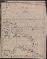
"N.B. Les chiffres de sondes indiquent les brasses angloises de 6. pieds anglois ou de 5. pieds 7. pouces 6. lignes 2/3 de France.", In lower right margin: No. 2 (Hyd. No. 58)., and Includes text and table.
Publisher:
Dépôt geńéral des cartes, plans et journaux de la marine,
Subject (Geographic):
Newfoundland and Labrador--Maps--Early works to 1800
Subject (Name):
France. Dépôt des cartes et plans de la marine and Lane, Michael, fl. 1768-1784
Subject (Topic):
Coasts--Newfoundland and Labrador--Maps--Early works to 1800 and Nautical charts--Newfoundland and Labrador--Early works to 1800
Depths shown by soundings., In lower right margin: Prix trente sols., In upper right margin: No. 1 (Hyd. No. 57)., Includes table and notes., and Prime meridian: Paris.
Publisher:
Dépôt Général des Cartes, Plans et Journaux de la Marine,
Subject (Geographic):
Maritime Provinces--Maps--Early works to 1800, Newfoundland and Labrador--Maps--Early works to 1800, and Saint Lawrence, Gulf of--Maps--Early works to 1800
Subject (Topic):
Coasts--Maritime Provinces--Maps--Early works to 1800, Coasts--Newfoundland and Labrador--Maps--Early works to 1800, Nautical charts--Grand Banks of Newfoundland--Early works to 1800, and Nautical charts--Maritime Provinces--E
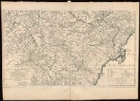
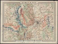
Bottom Margin: Bataille de Rezonville (16 Août 8h. du soir) -- Bataille de Gravelotte + St. Privat. (18 Août 7h du soir) -- Bataille de Borny (14 Août 8h du soir)., Coordinates not present on map and are approximated., Relief shown by hachures., and Troop locati
Publisher:
Hédin,
Subject (Geographic):
Moselle (France : 1790-1871)--Maps.
Subject (Topic):
Franco-Prussian War, 1870-1871--Campaigns--France, Eastern--Maps.
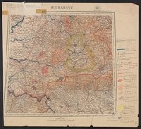
Ms. legend along right side of sheet corresponding with ms. notes on map. Paper affixed to upper left corner of sheet with note "This map and others similarly annotated were supplied to the American Peace Commission by the French Geographi