Skip to search
Skip to main content
Skip to first result
Search
You Searched For
Access
Public
Genre
Maps
Language
French
Publication Place
[Paris] :
New Search
Search Results
Creator:
Published / Created:
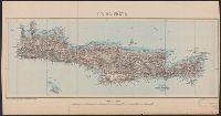
[192-?]
Call Number:
4894 1905
Container / Volume:
BRBL_00267
Image Count:
1
Resource Type:
Maps, Atlases & Globes
Description:
"Prix 1f." and Relief shown by shading. Depths shown by soundings and bathymetric tints.
Publisher:
Service géographique de l'Armée,
Subject (Geographic):
Crete (Greece)--Maps
Found in:
Beinecke Rare Book and Manuscript Library > Ile de Crète [cartographic material] / dessiné et héliogravé au Service géographique de l'Armée.
Published / Created:
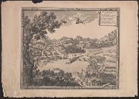
[1700?]
Call Number:
38 1659
Container / Volume:
BRBL_00151
Image Count:
1
Resource Type:
Maps, Atlases & Globes
Description:
Index.
Publisher:
A. Perelle fecit.,
Subject (Geographic):
France--Maps--Early works to 1800
Found in:
Beinecke Rare Book and Manuscript Library > L'Isle de la Conference ou la Paix generalle a esté conclue entre la France et l'Espagne le 7. Novemb. 1659.
Creator:
Published / Created:
[1751?]
Call Number:
3614 1751
Container / Volume:
BRBL_00135
Image Count:
1
Resource Type:
Maps, Atlases & Globes
Description:
"Guill. Delahaye, sculpsit.", Ornamental cartouche., Relief shown pictorially., Sheet 50.6 x 67.1 cm., and Stamp on verso: 80.
Publisher:
[publisher not identified],
Subject (Geographic):
Prussia (Germany)--Maps--Early works to 1800, Prussia, East (Poland and Russia)--Maps--Early works to 1800, and Prussia, West (Poland)--Maps--Early works to 1800
Subject (Name):
Haye, G. de la and Hughes, Thomas Lowe,--1925---Ownership
Found in:
Beinecke Rare Book and Manuscript Library > La Prusse divisée en Prusse Royale, et Prusse Ducale : laquelle a eté érigée en Royaume par l'Empereur Leopold en faveur de Frederic I. Elect. de Brandebourg couronée en Janvier 1701 / par le Sr. Robert, géographe.
Published / Created:
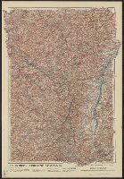
1916
Call Number:
11hc 1916HB
Container / Volume:
BRBL_00010C
Image Count:
1
Resource Type:
Maps, Atlases & Globes
Alternative Title:
Lorraine et Alsace
Description:
"Front au 1er. Janvier 1916.", "Supplément à l'illustration.", Ms. note outside bottom right margin "L'illus MY'19"., and Shows location of Western Front, railways, roads, canals, borders, and fortifications.
Publisher:
G. Peltier,
Subject (Geographic):
France--Maps
Subject (Topic):
World War, 1914-1918--Maps
Found in:
Beinecke Rare Book and Manuscript Library > Le Front = Lorraine et Alsace / dressé et dessiné́ par G. Peltier.
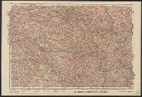
Published / Created:
1916
Call Number:
11hc 1916H
Container / Volume:
BRBL_00010C
Image Count:
1
Resource Type:
Maps, Atlases & Globes
Description:
"Front au 1er. Janvier 1916.", "Supplément à l'illustration.", Ms. note outside bottom right margin "L'illus My'19"., and Shows location of Western Front, railways, roads, canals, borders, and fortifications.
Publisher:
G. Peltier,
Subject (Geographic):
France--Maps
Subject (Topic):
World War, 1914-1918--Maps
Found in:
Beinecke Rare Book and Manuscript Library > Le Front de Soissons a Nancy / dressé et dessiné́ par G. Peltier.
Creator:
Published / Created:
1873
Call Number:
38 P21 1873A
Container / Volume:
BRBL_00163
Image Count:
1
Resource Type:
Maps, Atlases & Globes
Description:
Inset: Fortifications et environs de Paris.
Publisher:
Gravé par A. Martin,
Subject (Geographic):
Paris (France)--Maps
Found in:
Beinecke Rare Book and Manuscript Library > Le Plan de Paris de 1873 [cartographic material] / par le dr. Ermète Pierotti.
Published / Created:
[1776?]
Call Number:
32 1767
Container / Volume:
BRBL_00043
Image Count:
1
Resource Type:
Maps, Atlases & Globes
Publisher:
E. hanssard Fecit,
Subject (Geographic):
England--Maps--Early works to 1800
Found in:
Beinecke Rare Book and Manuscript Library > Le Royaume D'Angletere ... Par le Sr. Robert Geographe.
Published / Created:
[1700?]
Call Number:
38hc 1684
Container / Volume:
BRBL_00172
Image Count:
1
Resource Type:
Maps, Atlases & Globes
Publisher:
Chez. l'Autheur. rüe St. André des arts, Porte de Bucy,
Subject (Geographic):
France--Maps--Early works to 1800
Found in:
Beinecke Rare Book and Manuscript Library > Les Attaques de la ville de Gennes et du Fauxbourg de St. Pierre d'Arene. par l'Armeé navale du Roy Commandeépar le Marquis du Quesne, le 24. May 1684. C. Bevey Sculp. A Paris.
Published / Created:
1745
Call Number:
11 1720
Container / Volume:
BRBL_00004
Image Count:
1
Resource Type:
Maps, Atlases & Globes
Description:
"Avec privilege.", Double-hemispherical world map., and Preliminary record.
Publisher:
Ph. Buache ... ,
Subject (Geographic):
World--Maps--Early works to 1800
Subject (Topic):
World maps--Early works to 1800
Found in:
Beinecke Rare Book and Manuscript Library > Mappemond a l'usage du Roy / par Guillaume Delisle ...
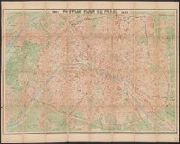
Published / Created:
1876
Call Number:
38 P21 1876A
Container / Volume:
BRBL_00163
Image Count:
1
Resource Type:
Maps, Atlases & Globes
Publisher:
Lanée,
Subject (Geographic):
Paris (France)--Maps and Paris Metropolitan Area (France)--Maps
Subject (Topic):
Cab and omnibus service--France--Paris--Maps and Roads--France--Paris--Maps
Found in:
Beinecke Rare Book and Manuscript Library > Nouveau plan de Paris, 1876 [cartographic material] / Lanée, Éditeur-Géographie ; gravé par Erhard-Sehièble.
Branch:v1.61.8 ,Deployed:2024-06-20T11:14:55-04:00