Includes text regarding first European discoveries., Relief shown pictorially., and Yale copy accompanied by: Description du fameux Cap de Bonne Esperance / par N. de Fer. -- 1 leaf ; 28 x 40 cm.
"Longitude du meridien de l'Isle de Fer.", Appears in Bellin's Atlas maritime., and Ms. notes on verso. Hand col. Sheet measures 57.3 x 79.8 cm. Cross Collection no. 168.
Publisher:
Dépot de la Marine],
Subject (Geographic):
Canada--Maps--Early works to 1800
Subject (Name):
Bellin, Jacques Nicolas, 1703-1772. Atlas maritime
"Longitude du meridien de l'Isle de Fer.", Appears in Bellin's Atlas maritime., and Stamp: Thorne Collection of Cartogaphy and Geography. Stamp: Karpinski-von Wieser Map Collection. "159"--Manuscript note.
Publisher:
Dépot de la Marine],
Subject (Geographic):
Canada--Maps--Early works to 1800
Subject (Name):
Bellin, Jacques Nicolas, 1703-1772. Atlas maritime and Thorne Collection of Cartogaphy and Geography Stamp
Appears in: Charlevoix, Père de. Histoire et description generale de la Nouvelle France [Paris, 1744]., Coordinates not present on map and are approximated., Includes index of important city buildings., Left margin: "10.", Oriented with north towards upper right., and Sheet measures 23 x 32 cm.
Publisher:
s.n.],
Subject (Geographic):
New Orleans (La.)--Maps--Early works to 1800
Subject (Name):
Charlevoix, Pierre-François-Xavier de, 1682-1761. Histoire et description generale de la Nouvelle France. and Heulland, Guillaume d', -approximately 1770
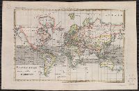
From Bonne's Atlas de toutes les parties connues du globe terrestre ... [Paris : J.L. Pellet, 1780?]., Hand col. Sheet measures 26 x 39 cm. Verso: "Projection de Mercator" in ink ms. Lada-Mocarski Collection., Meridians: Ferro, Paris., and Top left, in margin: "
Publisher:
J.L. Pellet,
Subject (Name):
Bonne, Rigobert, 1727-1794. Atlas de toutes les parties connues du globe terrestre .. and Pellet, J.-L. (Jean-Léonard), publisher
Subject (Topic):
Cartographers--France--18th century and World maps--Early works to 1800
Bar scales given in "mille pas géometriques," "lieues de Hongrie," and "lieues communes d'Allemagne"., Prime meridian: Ferro., Relief shown pictorially., Stamp on verso: 78. Sheet measures 50.5 x 66.6 cm., and Variant with "ordinaire du Roi," privilege statement
Publisher:
Gilles Robert de Vaugondy?,
Subject (Geographic):
Balkan Peninsula--Maps--Early works to 1800, Europe, Central--Maps--Early works to 1800, and Hungary--Maps--Early works to 1800