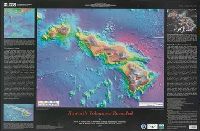
Eakins, Barry W Kaiyō Kagaku Gijutsu Sentā Monterey Bay Aquarium Research Institute University of Hawaii (System). School of Ocean and Earth Science and Technology
Published / Created:
2003
Call Number:
231 2003
Container / Volume:
BRBL_00020
Image Count:
1
Resource Type:
Maps, Atlases & Globes
Alternative Title:
Geologic investigations series / U.S. Department of the Interior, U.S. Geological Survey ; I-2809 and Geologic investigations series ; I-2809.
Description:
"Not to be used for navigation.", Ancillary maps: Bathymetry of the northwest Pacific Ocean -- 3-D perspective view of Hawaii -- Interpretive map of Hawaii's volcanoes., Bibliography., Includes text., and Relief and depths shown by satellite imagery.
Publisher:
U.S. Dept. of the Interior, U.S. Geological Survey,
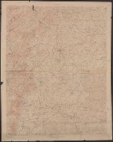
"Engraved Dec. 1910 by U.S.G.S.", "Surveyed in 1885 and 1906-1909 in cooperation with the states of Pennsylvania and Maryland.", Datum is mean sea level., Gettysburg, Fairfield, Emmitsburg, and Taneytown atlas sheets combined in this map., and Relief shown by contours and spot heights. Contour interval 20 feet.