Skip to search
Skip to main content
Skip to first result
Search
You Searched For
Date
-
Resource Type
Maps, Atlases & Globes
Language
English
Creator
Cope, Emmor B
Publication Place
[S.l. :
New Search
Search Results
Creator:
Published / Created:
1919
Call Number:
774AM G33 1919
Container / Volume:
BRBL_00500
Image Count:
1
Resource Type:
Maps, Atlases & Globes
Description:
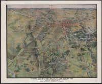
Description derived from published bibliography. and Panoramic map, with Round Top in the foreground, showing roads, railroads, field patterns, woodland, observation towers, monuments, and houses.
Publisher:
s.n.] ,
Subject (Geographic):
Gettysburg National Military Park (Pa.)--Maps
Found in:
Beinecke Rare Book and Manuscript Library > Perspective view of Gettysburg National Military Park / drawn under the direction of the Gettysburg National Park Commission, Colonel John P. Nicholson, Chairman, Major Charles A. Richardson, Commissioner. Drawing made February, 1919, by Lieut.-Colonel E.
Branch:v1.61.6 ,Deployed:2024-06-12T09:55:31-04:00