Skip to search
Skip to main content
Skip to first result
Search
You Searched For
Repository
Beinecke Rare Book and Manuscript Library
Format
cartographic
Genre
Manuscript maps
Genre
Maps
Publication Place
[S.l. :
New Search
Search Results
Published / Created:
1953?]
Call Number:
11hcf 1919A-4
Container / Volume:
BRBL_00010N
Image Count:
1
Resource Type:
Maps, Atlases & Globes
Description:
"CS- April 14, 1953.".
Publisher:
R.J. Kerner,
Subject (Geographic):
Poland--Maps
Found in:
Beinecke Rare Book and Manuscript Library > Small sketch map of Poland probably drawn by R.J. Kerner to illustrate hastily proposed Czech-Jugoslav Corridor.
Published / Created:
1919?]
Call Number:
11hcf 1919C-1-2
Container / Volume:
BRBL_00010S
Image Count:
1
Resource Type:
Maps, Atlases & Globes
Description:
Map drawn in crayon. and Title supplied by cataloger.
Publisher:
s.n.,
Subject (Geographic):
Balkan Peninsula--Maps
Found in:
Beinecke Rare Book and Manuscript Library > [Manuscript Map of the Balkan Peninsula].
Published / Created:
1878?]
Call Number:
11hcf 1919C-1-1
Container / Volume:
BRBL_00010S
Image Count:
1
Resource Type:
Maps, Atlases & Globes
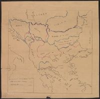
Description:
Legend indicates boundaries according to San Stefano in pink crayon, and boundaries according to Berlin in blue crayon. and Title supplied by cataloger.
Publisher:
s.n.,
Subject (Geographic):
Balkan Peninsula--Maps and Europe, Eastern--Maps
Subject (Topic):
Boundaries--Balkan Peninsula--Russo-Turkish War, 1877-1878 and Boundaries--Europe, Eastern--Russo-Turkish War, 1877-1878
Found in:
Beinecke Rare Book and Manuscript Library > [Manuscript Map showing boundaries according to the Treaty of Berlin and the Treaty of San Stefano].
Published / Created:
1919?]
Call Number:
11hcf 1919C-3-13
Container / Volume:
BRBL_00010U
Image Count:
1
Resource Type:
Maps, Atlases & Globes
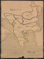
Description:
Politcal boundaries outlined and labeled in pink. and Title supplied by cataloger.
Publisher:
s.n.,
Subject (Geographic):
Balkan Peninsula--Maps and Europe, Eastern--Maps
Found in:
Beinecke Rare Book and Manuscript Library > [Manuscript map of Balkan Peninsula and Eastern Europe].
Published / Created:
1919?]
Call Number:
11hcf 1919C-3-15
Container / Volume:
BRBL_00010U
Image Count:
1
Resource Type:
Maps, Atlases & Globes
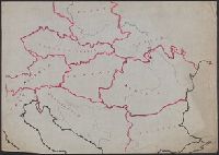
Description:
Area encompassing Bohemia, Moravia, Silesi, and Slovak districts outlined in yellow, green, and pink. and Title supplied by cataloger.
Publisher:
s.n.,
Subject (Geographic):
Balkan Peninsula--Maps and Europe, Eastern--Maps
Found in:
Beinecke Rare Book and Manuscript Library > [Manuscript map of Balkan Peninsula and Eastern Europe].
Published / Created:
1919?]
Call Number:
11hcf 1919C-1-3
Container / Volume:
BRBL_00010S
Image Count:
1
Resource Type:
Maps, Atlases & Globes
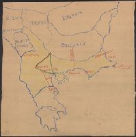
Description:
Map includes historical regions of Eastern Roumelia, Dobruja, and Bessarabia. Borders drawn in black ink, countries outlined in crayon. and Title supplied by cataloger.
Publisher:
s.n.,
Subject (Geographic):
Balkan Peninsula--Maps and Europe, Eastern--Maps
Subject (Topic):
Boundaries--Balkan Peninsula--Maps and Boundaries--Europe, Eastern--Maps
Found in:
Beinecke Rare Book and Manuscript Library > [Manuscript map of the Balkan Peninsula].
Branch:v1.61.6 ,Deployed:2024-06-12T09:55:36-04:00