Search
You Searched For
Search Results
- Published / Created:
- 1633?]
- Call Number:
- 322 1633
- Container / Volume:
- BRBL_00059
- Image Count:
- 2
- Resource Type:
- Maps, Atlases & Globes
- Found in:
- Beinecke Rare Book and Manuscript Library > [Channel Islands]
- Published / Created:
- 1671]
- Call Number:
- 70 1671
- Container / Volume:
- BRBL_00354
- Image Count:
- 1
- Resource Type:
- Maps, Atlases & Globes
- Found in:
- Beinecke Rare Book and Manuscript Library > Carte de l'Amerique : corrigée et augmentée, dessus toutes les aultres cy deuant, 1671.
- Published / Created:
- 1673]
- Call Number:
- 56 1644
- Container / Volume:
- BRBL_00294
- Image Count:
- 1
- Resource Type:
- Maps, Atlases & Globes
- Found in:
- Beinecke Rare Book and Manuscript Library > Jing ban tian wen quan tu.
- Creator:
- Massa, Isaac, 1587-1635
- Published / Created:
- ca. 1680]
- Call Number:
- 352 1630
- Container / Volume:
- BRBL_00722
- Image Count:
- 1
- Resource Type:
- Maps, Atlases & Globes
- Found in:
- Beinecke Rare Book and Manuscript Library > Moscoviae pars australis / auctore Isaaco Maβa.
- Published / Created:
- 1680?]
- Call Number:
- 51 1680A
- Container / Volume:
- BRBL_00278
- Image Count:
- 1
- Resource Type:
- Maps, Atlases & Globes
- Found in:
- Beinecke Rare Book and Manuscript Library > Terra sancta : sive Palestina in qua Christus peregrin atus est.
- Creator:
- Anville, Jean Baptiste Bourguignon d', 1697-1782
- Published / Created:
- 17--?]
- Call Number:
- 71 1769A
- Container / Volume:
- BRBL_00364
- Image Count:
- 1
- Resource Type:
- Maps, Atlases & Globes
- Found in:
- Beinecke Rare Book and Manuscript Library > A map of North America : from D'Anville, 1769.
- Published / Created:
- 17--?].
- Call Number:
- 71 1760A
- Container / Volume:
- BRBL_00364
- Image Count:
- 1
- Resource Type:
- Maps, Atlases & Globes
- Found in:
- Beinecke Rare Book and Manuscript Library > Carte de la Nouvelle France : où se voit le cours des Grandes Rivieres de S. Laurens & de Mississipi, aujour d'hui S. Louis, aux environs des-quelles se trouvent les etats, païs, nations, peuples &c. de la Floride, de la Louïsiane, de la Virginie, de l
- Published / Created:
- 1700?]
- Call Number:
- 314 1700
- Container / Volume:
- BRBL_00038
- Image Count:
- 1
- Resource Type:
- Maps, Atlases & Globes
- Found in:
- Beinecke Rare Book and Manuscript Library > Lumen historiarum per occidentem / ex conatibus Fran. Haraet, antverpiae.
- Creator:
- Gaudy, John
- Published / Created:
- 1715?]
- Call Number:
- 72 1715
- Container / Volume:
- BRBL_00372
- Image Count:
- 1
- Resource Type:
- Maps, Atlases & Globes
- Found in:
- Beinecke Rare Book and Manuscript Library > A chart, shewing part of the sea coast of Newfoundland from the Bay of Bulls to Little Placentia / exactly and carefully lay'd down by John Gaudy, anno 1715.
- Published / Created:
- between 1722 and 1799?]
- Call Number:
- 70 1722A
- Container / Volume:
- BRBL_00355
- Image Count:
- 1
- Resource Type:
- Maps, Atlases & Globes
- Found in:
- Beinecke Rare Book and Manuscript Library > Amerika.
- Published / Created:
- 177-?]
- Call Number:
- 71 1769
- Container / Volume:
- BRBL_00364
- Image Count:
- 1
- Resource Type:
- Maps, Atlases & Globes
- Found in:
- Beinecke Rare Book and Manuscript Library > Partie de la carte du Capitaine Cluny auteur d'un ouvrage anglois intitulé American traveller publié à Londre en 1769.
- Published / Created:
- 1770]
- Call Number:
- 36 1770H
- Container / Volume:
- BRBL_00118
- Image Count:
- 1
- Resource Type:
- Maps, Atlases & Globes
- Found in:
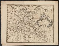
- Beinecke Rare Book and Manuscript Library > A correct map of the north east part of Germany...
- Published / Created:
- 1770]
- Call Number:
- 36 1770G
- Container / Volume:
- BRBL_00118
- Image Count:
- 1
- Resource Type:
- Maps, Atlases & Globes
- Found in:
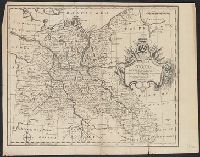
- Beinecke Rare Book and Manuscript Library > A correct map of the north east part of Germany...
- Published / Created:
- 1770]
- Call Number:
- 36 1770F
- Container / Volume:
- BRBL_00118
- Image Count:
- 1
- Resource Type:
- Maps, Atlases & Globes
- Found in:
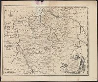
- Beinecke Rare Book and Manuscript Library > A correct map of the south east part of Germany...
- Published / Created:
- 1770]
- Call Number:
- 36 1770E
- Container / Volume:
- BRBL_00118
- Image Count:
- 1
- Resource Type:
- Maps, Atlases & Globes
- Found in:
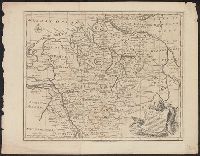
- Beinecke Rare Book and Manuscript Library > A correct map of the south east part of Germany...
- Published / Created:
- 1770]
- Call Number:
- 36 1770D
- Container / Volume:
- BRBL_00118
- Image Count:
- 1
- Resource Type:
- Maps, Atlases & Globes
- Found in:
- Beinecke Rare Book and Manuscript Library > A new and correct map of the south west part of Germany...
- Published / Created:
- 1770]
- Call Number:
- 36 1770C
- Container / Volume:
- BRBL_00118
- Image Count:
- 1
- Resource Type:
- Maps, Atlases & Globes
- Found in:
- Beinecke Rare Book and Manuscript Library > A new and correct map of the south west part of Germany...
- Published / Created:
- 1770]
- Call Number:
- 36 1770B
- Container / Volume:
- BRBL_00118
- Image Count:
- 1
- Resource Type:
- Maps, Atlases & Globes
- Found in:
- Beinecke Rare Book and Manuscript Library > A correct map of the north west part of Germany...
- Published / Created:
- 1770]
- Call Number:
- 36 1770A
- Container / Volume:
- BRBL_00118
- Image Count:
- 1
- Resource Type:
- Maps, Atlases & Globes
- Found in:
- Beinecke Rare Book and Manuscript Library > A correct map of the north west part of Germany...
- Published / Created:
- 1772]
- Call Number:
- 844 1772A
- Container / Volume:
- BRBL_00601
- Image Count:
- 1
- Resource Type:
- Maps, Atlases & Globes
- Found in:
- Beinecke Rare Book and Manuscript Library > Carte de la Californie et des pays nord-ouest : separés de l'Asie par le Détroit d'Anian, extraite de deux cartes publiées au commencement du 17e siecle / par le S. Robert de Vaugondy ... 1772.
- Creator:
- Robert de Vaugondy, Didier, 1723-1786
- Published / Created:
- 1772]
- Call Number:
- 844 1772
- Container / Volume:
- BRBL_00601
- Image Count:
- 1
- Resource Type:
- Maps, Atlases & Globes
- Found in:
- Beinecke Rare Book and Manuscript Library > Carte de la Californie et des pays nord-ouest : separés de l'Asie par le Détroit d'Anian, extraite de deux cartes publiées au commencement du 17e siecle / par le S. Robert de Vaugondy ... 1772.
- Published / Created:
- 1775?]
- Call Number:
- 764 B65 1775B
- Container / Volume:
- BRBL_00454
- Image Count:
- 1
- Resource Type:
- Maps, Atlases & Globes
- Found in:
- Beinecke Rare Book and Manuscript Library > Sketch of the action on the heights of Charlestown 17 June 1775 between his majestys troops under the command of M. Gnl. Howe and a large body of American rebels.
- Published / Created:
- 1780?]
- Call Number:
- 771cea N49 1780
- Container / Volume:
- BRBL_00493
- Image Count:
- 1
- Resource Type:
- Maps, Atlases & Globes
- Found in:
- Beinecke Rare Book and Manuscript Library > New York Harbour.
- Creator:
- Kitchin, Thomas, d. 1784
- Published / Created:
- 178-?]
- Call Number:
- 71 1784B
- Container / Volume:
- BRBL_00366
- Image Count:
- 1
- Resource Type:
- Maps, Atlases & Globes
- Found in:
- Beinecke Rare Book and Manuscript Library > North America / drawn from the latest & best authorities by Thos. Kitchin.
- Published / Created:
- 178-?]
- Call Number:
- 71 1780C
- Container / Volume:
- BRBL_00366
- Image Count:
- 1
- Resource Type:
- Maps, Atlases & Globes
- Found in:
- Beinecke Rare Book and Manuscript Library > A map of America between latitudes 40 and 70 north, and longitudes 45 and 180 west : exhibiting the principal trading stations of the North West Company.
- Published / Created:
- ca. 1790?]
- Call Number:
- 71 1790C
- Container / Volume:
- BRBL_00367
- Image Count:
- 1
- Resource Type:
- Maps, Atlases & Globes
- Found in:
- Beinecke Rare Book and Manuscript Library > [Amérique Septentrionale].
- Published / Created:
- ca. 1790?]
- Call Number:
- 71 1790
- Container / Volume:
- BRBL_00367
- Image Count:
- 1
- Resource Type:
- Maps, Atlases & Globes
- Found in:
- Beinecke Rare Book and Manuscript Library > [Amérique Septentrionale].
- Published / Created:
- 18--]
- Call Number:
- 40 V55 1830
- Container / Volume:
- BRBL_00705
- Image Count:
- 1
- Resource Type:
- Maps, Atlases & Globes
- Found in:
- Beinecke Rare Book and Manuscript Library > [An unfinished manuscript map of the area around Venice, including Fusina, Marghera, Murano, S. Erasmo, Le Vignole, Lazzaretto and S. Spirito.]
- Creator:
- Rennell, James, 1742-1830
- Published / Created:
- 1800?]
- Call Number:
- 60 1792
- Container / Volume:
- BRBL_00324
- Image Count:
- 1
- Resource Type:
- Maps, Atlases & Globes
- Found in:
- Beinecke Rare Book and Manuscript Library > The route of Mr. Mungo Park : from Pisania to the River Gambia, to Silla, on the River Joliba or Niger, with his return by the southern route to Pisania / compiled from Mr. Park's observations, notes, & sketches by J. Rennell ; Scoles sculp.
- Published / Created:
- ca 1810]
- Call Number:
- 773 J487 1810
- Container / Volume:
- BRBL_00496
- Image Count:
- 1
- Resource Type:
- Maps, Atlases & Globes
- Found in:
- Beinecke Rare Book and Manuscript Library > A map of that part of the town of Jersey, commonly called Aharsimus.
- Creator:
- Carey, Mathew, 1760-1839
- Published / Created:
- 1814]
- Call Number:
- 80 1814D
- Container / Volume:
- BRBL_00532
- Image Count:
- 1
- Resource Type:
- Maps, Atlases & Globes
- Found in:
- Beinecke Rare Book and Manuscript Library > Missouri Territory formerly Louisiana / Lewis, del. ; Bower, sc.
- Published / Created:
- 183-?]
- Call Number:
- 816 Ir6 1837A
- Container / Volume:
- BRBL_00562
- Image Count:
- 1
- Resource Type:
- Maps, Atlases & Globes
- Found in:
- Beinecke Rare Book and Manuscript Library > Iron Mountain City.
- Creator:
- Featherstonhaugh, George William, 1780-1866
- Published / Created:
- 1835]
- Call Number:
- 814 M667 1835
- Container / Volume:
- BRBL_00558
- Image Count:
- 1
- Resource Type:
- Maps, Atlases & Globes
- Found in:
- Beinecke Rare Book and Manuscript Library > A reconnoissance of the Minnay Sotor Watapāh; or St. Peter's River to its sources / made in the year 1835 by G.W. Featherstonhaugh, U.S. geologist.
- Published / Created:
- 1837?]
- Call Number:
- 796 H37 1837
- Container / Volume:
- BRBL_00527A
- Image Count:
- 1
- Resource Type:
- Maps, Atlases & Globes
- Found in:
- Beinecke Rare Book and Manuscript Library > Survey of 5 leagues of land belonging to Wm P. Harris & others / lith. of P. Snell.
- Creator:
- Smith, M. L., Lieut
- Published / Created:
- 184-?]
- Call Number:
- 88 184X
- Container / Volume:
- BRBL_00645
- Image Count:
- 1
- Resource Type:
- Maps, Atlases & Globes
- Found in:
- Beinecke Rare Book and Manuscript Library > Map of the valley of Mexico, with a plan of the defences of the capital and the line of operations of the United States Army under Major General Scott in August and September 1847 / surveyed and drawn by Lieut. M.L. Smith and Brevt. Capt. E.L.F. Hardcastl
- Published / Created:
- 1840?]
- Call Number:
- 7715FB AS88 1840
- Container / Volume:
- BRBL_00493
- Image Count:
- 1
- Resource Type:
- Maps, Atlases & Globes
- Found in:
- Beinecke Rare Book and Manuscript Library > Map of the village of Astoria, Late Hallett's Cove & Ravenswood, Long Island, 1840.
- Published / Created:
- 1840 ?]
- Call Number:
- 486 1840
- Container / Volume:
- BRBL_00265
- Image Count:
- 1
- Resource Type:
- Maps, Atlases & Globes
- Found in:
- Beinecke Rare Book and Manuscript Library > Map of Extra-Peloponnesian Greece : as it stood at the beginning of the Peloponnesian war / by K. O. Muller.
- Published / Created:
- 184-?]
- Call Number:
- 38 L99 1850
- Container / Volume:
- BRBL_00158
- Image Count:
- 1
- Resource Type:
- Maps, Atlases & Globes
- Found in:
- Beinecke Rare Book and Manuscript Library > Plan of Lyons [cartographic material].
- Published / Created:
- 184-?]
- Call Number:
- 38 L99 1850
- Container / Volume:
- BRBL_00158
- Image Count:
- 1
- Resource Type:
- Maps, Atlases & Globes
- Found in:
- Beinecke Rare Book and Manuscript Library > Plan of Lyons [cartographic material].
- Published / Created:
- 1841?]
- Call Number:
- 815 N171 1841
- Container / Volume:
- BRBL_00560
- Image Count:
- 1
- Resource Type:
- Maps, Atlases & Globes
- Found in:
- Beinecke Rare Book and Manuscript Library > Plat of the town of Nashville.
- Creator:
- Blake, Jacob Edmund, 1811 or 12-1846
- Published / Created:
- 1842?]
- Call Number:
- 796fab Sa13 1842F
- Container / Volume:
- BRBL_00530
- Image Count:
- 1
- Resource Type:
- Maps, Atlases & Globes
- Found in:
- Beinecke Rare Book and Manuscript Library > Part of the boundary between the United States and Texas, north of the Sabine River from the 72nd mile mound to Red River / drawn from the notes of survey and copied for the use of the commissioners under the Convention of 25th April, 1838 by J. Edm.d Bla
- Creator:
- Blake, Jacob Edmund, 1811 or 12-1846
- Published / Created:
- 1842?]
- Call Number:
- 796fab Sa13 1842E
- Container / Volume:
- BRBL_00530
- Image Count:
- 1
- Resource Type:
- Maps, Atlases & Globes
- Found in:
- Beinecke Rare Book and Manuscript Library > Part of the boundary between the United States and Texas, north of Sabine River from the 39th [i.e. 36th] to the 72nd mile mound / drawn from the notes of survey and copied for the use of the commissioners under the Convention of 25th April 1838 by J. Edm
- Creator:
- Blake, Jacob Edmund, 1811 or 12-1846
- Published / Created:
- 1842?]
- Call Number:
- 796fab Sa13 1842D
- Container / Volume:
- BRBL_00530
- Image Count:
- 1
- Resource Type:
- Maps, Atlases & Globes
- Found in:
- Beinecke Rare Book and Manuscript Library > Part of the boundary between the United States and Texas, from Sabine River northward to the 36th mile mound / drawn from the notes of survey and copied for the use of the commissioners under the Convention of 25th April 1838, by J. Edm.d Blake 1st Lieut.
- Published / Created:
- 1845?]
- Call Number:
- 818fb 1845
- Container / Volume:
- BRBL_00565
- Image Count:
- 1
- Resource Type:
- Maps, Atlases & Globes
- Found in:
- Beinecke Rare Book and Manuscript Library > Map of the south western district, Louisiana ; South eastern district, Louisiana ; Map of the district north of Red River and part of N.W. District, LA. / Surveyor Generals Office, Donaldson, Oct. 29th 1845, P.T. Landry, Sur. Genl. La. Arkansas / Wm. Pel
- Published / Created:
- 1847 or 1848?]
- Call Number:
- 816fcm 1847
- Container / Volume:
- BRBL_00563
- Image Count:
- 1
- Resource Type:
- Maps, Atlases & Globes
- Found in:
- Beinecke Rare Book and Manuscript Library > Diagram of the state of Missouri.
- Published / Created:
- 1847?]
- Call Number:
- 815fcm 1847
- Container / Volume:
- BRBL_00561
- Image Count:
- 1
- Resource Type:
- Maps, Atlases & Globes
- Found in:
- Beinecke Rare Book and Manuscript Library > Sketch of the public surveys in Iowa.
- Published / Created:
- 185-?]
- Call Number:
- 846hc 1850
- Container / Volume:
- BRBL_00624
- Image Count:
- 1
- Resource Type:
- Maps, Atlases & Globes
- Found in:
- Beinecke Rare Book and Manuscript Library > [Six route operations of a United States military company in Oregon Territory].
- Creator:
- O'Farrell, Jasper, 1817-1875
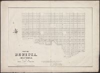
- Published / Created:
- 1850?]
- Call Number:
- 844 B437 1850
- Container / Volume:
- BRBL_00604
- Image Count:
- 2
- Resource Type:
- Maps, Atlases & Globes
- Found in:
- Beinecke Rare Book and Manuscript Library > Plan of Benicia, California : founded by Thomas O. Larkin and R. Simple, esq'rs.
- Creator:
- Russel, Andrew F
- Published / Created:
- 185-?]
- Call Number:
- 815 D273 1850
- Container / Volume:
- BRBL_00560
- Image Count:
- 1
- Resource Type:
- Maps, Atlases & Globes
- Found in:
- Beinecke Rare Book and Manuscript Library > Map of Davenport and its vicinity, Iowa / by Andrew F. Rufsel.
- Published / Created:
- 1850?]
- Call Number:
- 796 St24 1850
- Container / Volume:
- BRBL_00528
- Image Count:
- 1
- Resource Type:
- Maps, Atlases & Globes
- Found in:
- Beinecke Rare Book and Manuscript Library > Town of St. Mary's, Refugio Co., Texas.
- Published / Created:
- [ca. 1850]
- Call Number:
- 40gme 1850
- Container / Volume:
- BRBL_00230
- Image Count:
- 8
- Resource Type:
- Maps, Atlases & Globes
- Found in:
- Beinecke Rare Book and Manuscript Library > Topografia della zona di terrano corsa della strada : Profilo di livellazione delle pendenze della Strada, e della linea battuta della Strada.
- Published / Created:
- 1850?]
- Call Number:
- 40GCF 1850
- Container / Volume:
- BRBL_00229
- Image Count:
- 1
- Resource Type:
- Maps, Atlases & Globes
- Found in:
- Beinecke Rare Book and Manuscript Library > Profilo della livellazione ossia pendenza del cavo antico del redefossi dal travacatore a porta tosa, sino alla vecchiabbia / Mare Anto. dal Re Sei.
- Published / Created:
- 1850]
- Call Number:
- 40 V66 1850
- Image Count:
- 2
- Resource Type:
- Maps, Atlases & Globes
- Found in:
- Beinecke Rare Book and Manuscript Library > Corografia della Provincia di Vicenza nel Regno Lombardo-Veneto : distinta ne' suoi distretti e comuni censuari formata in base delle mappe del nuovo censimento.
- Published / Created:
- 1850]
- Call Number:
- 40 V59 1850
- Image Count:
- 2
- Resource Type:
- Maps, Atlases & Globes
- Found in:
- Beinecke Rare Book and Manuscript Library > Corografia della Provincia di Verona nel Regno Lombardo-Veneto : distinta ne' suoi distretti e comuni censuari formata in base delle mappe del nuovo censimento.
- Published / Created:
- ca. 1850]
- Call Number:
- 40 V55 1850
- Image Count:
- 2
- Resource Type:
- Maps, Atlases & Globes
- Found in:
- Beinecke Rare Book and Manuscript Library > Corografia della Provincia di Venezia nel Regno Lombardo-Veneto : distinta ne' suoi distretti e comuni censuarj formata in base delle mappe del nuovo censimento.
- Published / Created:
- 1850?]
- Call Number:
- 40 V248 1855
- Image Count:
- 1
- Resource Type:
- Maps, Atlases & Globes
- Found in:
- Beinecke Rare Book and Manuscript Library > Carta della Provincia della Valtellina / Giusseppe Pezze incise.
- Published / Created:
- 1850]
- Call Number:
- 40 T729 1850
- Image Count:
- 1
- Resource Type:
- Maps, Atlases & Globes
- Found in:
- Beinecke Rare Book and Manuscript Library > Corografia della Provincia di Treviso nel Regno Lombardo-Veneto : distinta ne' suoi distretti e comuni censuari formata in base delle mappe del nuovo censimento.
- Published / Created:
- 1850]
- Call Number:
- 40 P28 1850
- Container / Volume:
- BRBL_00214
- Image Count:
- 1
- Resource Type:
- Maps, Atlases & Globes
- Found in:
- Beinecke Rare Book and Manuscript Library > Corografia della Provincia di Pavia nel Regno Lombardo-Veneto : distinta ne' suoi distretti e comuni amministrativi e censuari secondo il vigente compartimento territoriale e formata in base delle Mappe dell'antico censimento Milanese.
- Published / Created:
- 1850]
- Call Number:
- 40 P13 1850
- Container / Volume:
- BRBL_00213
- Image Count:
- 1
- Resource Type:
- Maps, Atlases & Globes
- Found in:
- Beinecke Rare Book and Manuscript Library > Corografia della Provincia di Padua nel Regno Lombardo-Veneto : distinta ne' suoi distretti e comuni censuari formata in base delle mappe del nuovo censimento.
- Published / Created:
- 1850]
- Call Number:
- 40 M59 1850
- Container / Volume:
- BRBL_00211
- Image Count:
- 1
- Resource Type:
- Maps, Atlases & Globes
- Found in:
- Beinecke Rare Book and Manuscript Library > Corografia della Provincia di Milano nel Regno Lombardo-Veneto : distinta ne' suoi distretti e comuni amministrativi e censuari secondo il vigente compartimento territoriale e formata in base delle Mappe dell'antico censimento Milanese.
- Published / Created:
- 1850]
- Call Number:
- 40 F918 1850
- Container / Volume:
- BRBL_00208
- Image Count:
- 3
- Resource Type:
- Maps, Atlases & Globes
- Found in:
- Beinecke Rare Book and Manuscript Library > Corografia della Provincia del Friuli nel Regno Lombardo-Veneto : distinta ne' suoi distretti e comuni censuari formata in base delle mappe del nuovo censimento.
- Published / Created:
- 1850?]
- Call Number:
- 40 1850A
- Container / Volume:
- BRBL_00200
- Image Count:
- 1
- Resource Type:
- Maps, Atlases & Globes
- Found in:
- Beinecke Rare Book and Manuscript Library > Gegend zwischen Verona, Peschiera, und Mantova.
- Published / Created:
- 1850]
- Call Number:
- 40 B75 1850
- Container / Volume:
- BRBL_00205
- Image Count:
- 2
- Resource Type:
- Maps, Atlases & Globes
- Found in:
- Beinecke Rare Book and Manuscript Library > Corografia della Provincia di Brescia nel Regno Lombardo-Veneto : distinta ne' suoi distretti e comuni censuari formata in base delle mappe del nuovo censimento.
- Published / Created:
- 1850]
- Call Number:
- 40 B45 1850
- Container / Volume:
- BRBL_00205
- Image Count:
- 3
- Resource Type:
- Maps, Atlases & Globes
- Found in:
- Beinecke Rare Book and Manuscript Library > Corografia della Provincia di Bergamo nel Regno Lombardo-Veneto : distinta ne' suoi distretti e comuni censuari formata in base delle mappe del nuovo censimento.
- Published / Created:
- 1850?]
- Call Number:
- 40 B41 1850
- Container / Volume:
- BRBL_00204
- Image Count:
- 2
- Resource Type:
- Maps, Atlases & Globes
- Found in:
- Beinecke Rare Book and Manuscript Library > Corografia della provincia di Belluno nel Regno Lombardo Veneto : distinta ne' suoi distretti e comuni censuari, formata in base delle mappe del nuovo censimento.
- Creator:
- Smith, M.L
- Published / Created:
- 1853, 1854.
- Call Number:
- 792 1855C
- Container / Volume:
- BRBL_00518
- Image Count:
- 1
- Resource Type:
- Maps, Atlases & Globes
- Found in:
- Beinecke Rare Book and Manuscript Library > Map showing the different lines of survey across Florida for a canal between Espiritu Santo Bay and the St. Johns and Ocklawaha Rivers / by Lieut. M. L. Smith, Topog. Engrs., Lieut. F. T. Bryan, Topog. Engrs. and A. E. Drake, C. Engr.
- Creator:
- Ferrer, Fermin
- Published / Created:
- 1855
- Call Number:
- 895 1855
- Container / Volume:
- BRBL_00659
- Image Count:
- 1
- Resource Type:
- Maps, Atlases & Globes
- Found in:
- Beinecke Rare Book and Manuscript Library > Geographical map of the Republic of Nicaragua : with three plans and views / by Fermin Ferrer, Governor of the Western Dept.
- Creator:
- Arkansas. Surveyor's Office
- Published / Created:
- 1855]
- Call Number:
- 818 1855B
- Container / Volume:
- BRBL_00565
- Image Count:
- 1
- Resource Type:
- Maps, Atlases & Globes
- Found in:
- Beinecke Rare Book and Manuscript Library > Arkansas / Surveyor's Office Little Rock Oct. 18th 1855. Henry M. Rector, Sur. Genl. of Arks.
- Creator:
- Walling, Henry Francis, 1825-1888
- Published / Created:
- 1856
- Call Number:
- 764 D255 1856
- Container / Volume:
- BRBL_00457
- Image Count:
- 1
- Resource Type:
- Maps, Atlases & Globes
- Found in:
- Beinecke Rare Book and Manuscript Library > Map of the town of Dartmouth, Bristol County Mass. : made by order of the town / under the direction of H.F. Walling, sup. of the state map.
- Creator:
- Villavicencio, Manuel, 1822-1871
- Published / Created:
- 1858
- Call Number:
- 99 1858
- Container / Volume:
- BRBL_00679
- Image Count:
- 1
- Resource Type:
- Maps, Atlases & Globes
- Found in:
- Beinecke Rare Book and Manuscript Library > Carta corografica de la republica del Ecuador / Manuel Villavicencio ; lit. é imp. de F. Mayer y Ca.
- Published / Created:
- 1858
- Call Number:
- 38 C42 1858
- Container / Volume:
- BRBL_00156
- Image Count:
- 1
- Resource Type:
- Maps, Atlases & Globes
- Found in:
- Beinecke Rare Book and Manuscript Library > Plan Topographique de la Rade, du Port, de la Ville, et des environs de Cherbourg / par Ch. Larochette.
- Published / Created:
- 1859]
- Call Number:
- 40hc 1859J
- Container / Volume:
- BRBL_00231
- Image Count:
- 1
- Resource Type:
- Maps, Atlases & Globes
- Found in:
- Beinecke Rare Book and Manuscript Library > Battaglia del Volturno.
- Published / Created:
- 1860?]
- Call Number:
- 40 V867 1860E
- Container / Volume:
- BRBL_00227
- Image Count:
- 1
- Resource Type:
- Maps, Atlases & Globes
- Found in:
- Beinecke Rare Book and Manuscript Library > Cne. di Voghera Fo. LXI.
- Published / Created:
- 186-?]
- Call Number:
- 815ad C832 1860
- Container / Volume:
- BRBL_00561
- Image Count:
- 1
- Resource Type:
- Maps, Atlases & Globes
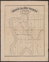
- Found in:
- Beinecke Rare Book and Manuscript Library > Council Bluffs vicinity / A. Cochran, dealer in lands, lots and land warrants.
- Published / Created:
- 186-?]
- Call Number:
- 815ad C832 1860
- Container / Volume:
- BRBL_00561
- Image Count:
- 1
- Resource Type:
- Maps, Atlases & Globes
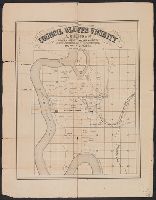
- Found in:
- Beinecke Rare Book and Manuscript Library > Council Bluffs vicinity / A. Cochran, dealer in lands, lots and land warrants.
- Published / Created:
- 1860?]
- Call Number:
- 796gme 1860
- Container / Volume:
- BRBL_00531
- Image Count:
- 1
- Resource Type:
- Maps, Atlases & Globes
- Found in:
- Beinecke Rare Book and Manuscript Library > A geographically correct map of the Red River, Sabine & Western Railway (under construction) and connections : showing distribution of pine forests (compiled from maps of U.S. government), also location of coal, iron, and oil deposits.
- Published / Created:
- 1860?]
- Call Number:
- 40 V867 1860D
- Container / Volume:
- BRBL_00227
- Image Count:
- 1
- Resource Type:
- Maps, Atlases & Globes
- Found in:
- Beinecke Rare Book and Manuscript Library > Cne. di Voghera Fo. XLIV.
- Published / Created:
- 1860
- Call Number:
- 464 1860
- Container / Volume:
- BRBL_00261
- Image Count:
- 1
- Resource Type:
- Maps, Atlases & Globes
- Found in:
- Beinecke Rare Book and Manuscript Library > [Dalmatia].
- Published / Created:
- 1860?]
- Call Number:
- 428 B63 1860
- Container / Volume:
- BRBL_00248
- Image Count:
- 2
- Resource Type:
- Maps, Atlases & Globes
- Found in:
- Beinecke Rare Book and Manuscript Library > Umgebungs-Karte von Bozen.
- Published / Created:
- 186-?]
- Call Number:
- 40gme M769 1864
- Container / Volume:
- BRBL_00230
- Image Count:
- 1
- Resource Type:
- Maps, Atlases & Globes
- Found in:
- Beinecke Rare Book and Manuscript Library > Corografia della Brianza col tracciamento della strada ferrata Monza-Lecco destinata ad attraversarla.
- Published / Created:
- 1860?]
- Call Number:
- 40 V867 1860C
- Container / Volume:
- BRBL_00227
- Image Count:
- 1
- Resource Type:
- Maps, Atlases & Globes
- Found in:
- Beinecke Rare Book and Manuscript Library > Cne. di Voghera Fo. XLIII.
- Published / Created:
- 1860?]
- Call Number:
- 40 V867 1860B
- Container / Volume:
- BRBL_00227
- Image Count:
- 1
- Resource Type:
- Maps, Atlases & Globes
- Found in:
- Beinecke Rare Book and Manuscript Library > Cne. di Voghera Fo. XLV (Allegato A).
- Published / Created:
- 1860?]
- Call Number:
- 40 V867 1860A
- Container / Volume:
- BRBL_00227
- Image Count:
- 1
- Resource Type:
- Maps, Atlases & Globes
- Found in:
- Beinecke Rare Book and Manuscript Library > Provincia di Pavia, Comune di Voghera : Quadro d'unione.
- Published / Created:
- 1860?]
- Call Number:
- 40 V682 1860
- Container / Volume:
- BRBL_00227
- Image Count:
- 1
- Resource Type:
- Maps, Atlases & Globes
- Found in:
- Beinecke Rare Book and Manuscript Library > Cne. di Vigevano Fo. XXXII.
- Published / Created:
- 1860?]
- Call Number:
- 40 St81 1860C
- Image Count:
- 1
- Resource Type:
- Maps, Atlases & Globes
- Found in:
- Beinecke Rare Book and Manuscript Library > Cne. di Stradella. Fo. XVII.
- Published / Created:
- 1860?]
- Call Number:
- 40 St81 1860B
- Image Count:
- 1
- Resource Type:
- Maps, Atlases & Globes
- Found in:
- Beinecke Rare Book and Manuscript Library > Cne. di Stradella. Fo. XVI.
- Published / Created:
- 1860?]
- Call Number:
- 40 St81 1860A
- Image Count:
- 1
- Resource Type:
- Maps, Atlases & Globes
- Found in:
- Beinecke Rare Book and Manuscript Library > Cne. di Stradella. Fo. XVIII.
- Published / Created:
- 1860?]
- Call Number:
- 40 St81 1860
- Image Count:
- 1
- Resource Type:
- Maps, Atlases & Globes
- Found in:
- Beinecke Rare Book and Manuscript Library > Cne. di Stradella. Fo. XIV.
- Published / Created:
- 1860?]
- Call Number:
- 40 M841 1860
- Container / Volume:
- BRBL_00211
- Image Count:
- 1
- Resource Type:
- Maps, Atlases & Globes
- Found in:
- Beinecke Rare Book and Manuscript Library > Cne. di Mortara Fo. XVII.
- Published / Created:
- 1860?]
- Call Number:
- 40 C275 1860A
- Container / Volume:
- BRBL_00206
- Image Count:
- 1
- Resource Type:
- Maps, Atlases & Globes
- Found in:
- Beinecke Rare Book and Manuscript Library > Cne. di Casteggio Fo. XI (Allegato A).
- Published / Created:
- 1860?]
- Call Number:
- 40 C275 1860
- Container / Volume:
- BRBL_00206
- Image Count:
- 1
- Resource Type:
- Maps, Atlases & Globes
- Found in:
- Beinecke Rare Book and Manuscript Library > Cne. di Casteggio Fo. XI.
- Creator:
- United States Coast Survey
- Published / Created:
- 1864
- Call Number:
- 803cea 1864
- Container / Volume:
- BRBL_00542
- Image Count:
- 1
- Resource Type:
- Maps, Atlases & Globes
- Found in:
- Beinecke Rare Book and Manuscript Library > Ohio River between Mound City and Cairo / surveyed by the party of F.H. Gerdes, asst. assigned by A.D. Bache, Supdt. U.S. Coast Survey to act under orders of Rear Admiral D.D. Porter, U.S.N., commanding Mississippi Squadron.
- Creator:
- Peseux, M
- Published / Created:
- 1864
- Call Number:
- 801hc N17 1864
- Container / Volume:
- BRBL_00541
- Image Count:
- 1
- Resource Type:
- Maps, Atlases & Globes
- Found in:
- Beinecke Rare Book and Manuscript Library > Battlefields in front of Nashville where the United States forces commanded by Major General Geo. H. Thomas defeated and routed the Rebel army under General Hood, December 15th & 16th 1864 / surveyed and drawn under the direction of Gen: Tower by M. Peseu
- Published / Created:
- 1864
- Call Number:
- 405 C815 1864
- Container / Volume:
- BRBL_00236
- Image Count:
- 1
- Resource Type:
- Maps, Atlases & Globes
- Found in:
- Beinecke Rare Book and Manuscript Library > Pianura di Cornia in via di bonificamento.
- Published / Created:
- 1865?]
- Call Number:
- 5616 1865
- Container / Volume:
- BRBL_00299
- Image Count:
- 1
- Resource Type:
- Maps, Atlases & Globes
- Found in:
- Beinecke Rare Book and Manuscript Library > Shantung, China / compiled by Alex Armstrong, F.E.I.S.
- Published / Created:
- 1865
- Call Number:
- 40 N634 1865
- Container / Volume:
- BRBL_00212
- Image Count:
- 1
- Resource Type:
- Maps, Atlases & Globes
- Found in:
- Beinecke Rare Book and Manuscript Library > Opere di ristaurazione e di compimento del Porto di Nisida / G. Levi aut.
- Published / Created:
- 1866
- Call Number:
- 40hc C969 1866
- Container / Volume:
- BRBL_00232
- Image Count:
- 1
- Resource Type:
- Maps, Atlases & Globes
- Found in:
- Beinecke Rare Book and Manuscript Library > Piano dimostrativo del campo della Battaglia di Custoza : combattuta li 24 Giugno 1866.
- Creator:
- Union Pacific Railroad Company
- Published / Created:
- 1867?]
- Call Number:
- 824 Om1 1867
- Container / Volume:
- BRBL_00571
- Image Count:
- 1
- Resource Type:
- Maps, Atlases & Globes
- Found in:
- Beinecke Rare Book and Manuscript Library > Map to accompany report of J.L. Williams on the bridging of the Missouri River / Union Pacific Rail Road.