Search
You Searched For
Search Results
- Creator:
- George B. Cadwell & Co
- Published / Created:
- 1892
- Call Number:
- 811 T227 1892
- Container / Volume:
- BRBL_00553
- Image Count:
- 1
- Resource Type:
- Maps, Atlases & Globes
- Description:
- Cadastral map.
- Publisher:
- Geo. B. Cadwell & Co.],
- Subject (Geographic):
- Tecumseh (Mich.)--Maps
- Subject (Name):
- Lenawaee County, Michigan
- Subject (Topic):
- Real property--Michigan--Tecumseh--Maps
- Found in:
- Beinecke Rare Book and Manuscript Library > Map of Tecumseh : compiled for Geo. B. Cadwell & Co's. atlas of Lenawee County, Mich.
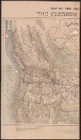
- Creator:
- Knight, E. H. (Edward H.)
- Published / Created:
- 1871]
- Call Number:
- 80gme 1871A
- Container / Volume:
- BRBL_00538
- Image Count:
- 2
- Resource Type:
- Maps, Atlases & Globes
- Alternative Title:
- Difference between the elevations of the Northern Pacific and the Union Pacific Railroads.
- Description:
- Michigan to Pacific Ocean, and parts of Canada.
- Publisher:
- s.n.,
- Subject (Name):
- Northern Pacific Railroad Company and Northern Pacific Railroad Company--Maps
- Subject (Topic):
- Coal mines and mining--Canada--Maps, Coal mines and mining--Northwestern States--Maps, and Railroads--Northwestern States--Maps
- Found in:
- Beinecke Rare Book and Manuscript Library > Map of the country tributary to the Northern Pacific Railroad / compiled from English, Canadian, and American official sources and original surveys by Edward H. Knight, Jan. 1st 1871.