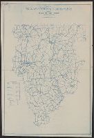
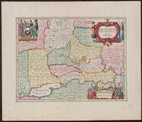
Search
You Searched For
Search Results
- Published / Created:
- 1913
- Call Number:
- 428 Ot9 1913
- Container / Volume:
- BRBL_00249
- Image Count:
- 4
- Resource Type:
- Maps, Atlases & Globes
- Found in:
- Beinecke Rare Book and Manuscript Library > Oetzthal & Stubai.
- Published / Created:
- [ca. 1850]
- Call Number:
- 40gme 1850
- Container / Volume:
- BRBL_00230
- Image Count:
- 8
- Resource Type:
- Maps, Atlases & Globes
- Found in:
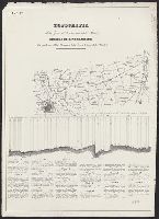
- Beinecke Rare Book and Manuscript Library > Topografia della zona di terrano corsa della strada : Profilo di livellazione delle pendenze della Strada, e della linea battuta della Strada.
- Published / Created:
- 1775?]
- Call Number:
- 764 B65 1775B
- Container / Volume:
- BRBL_00454
- Image Count:
- 1
- Resource Type:
- Maps, Atlases & Globes
- Found in:
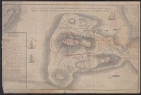
- Beinecke Rare Book and Manuscript Library > Sketch of the action on the heights of Charlestown 17 June 1775 between his majestys troops under the command of M. Gnl. Howe and a large body of American rebels.
- Published / Created:
- 1775?]
- Call Number:
- 764 B65 1775B
- Container / Volume:
- BRBL_00454
- Image Count:
- 1
- Resource Type:
- Maps, Atlases & Globes
- Found in:
- Beinecke Rare Book and Manuscript Library > Sketch of the action on the heights of Charlestown 17 June 1775 between his majestys troops under the command of M. Gnl. Howe and a large body of American rebels.
- Published / Created:
- ca 1810]
- Call Number:
- 773 J487 1810
- Container / Volume:
- BRBL_00496
- Image Count:
- 1
- Resource Type:
- Maps, Atlases & Globes
- Found in:
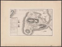
- Beinecke Rare Book and Manuscript Library > A map of that part of the town of Jersey, commonly called Aharsimus.
- Creator:
- Cope, Emmor B
- Published / Created:
- 1919
- Call Number:
- 774AM G33 1919
- Container / Volume:
- BRBL_00500
- Image Count:
- 1
- Resource Type:
- Maps, Atlases & Globes
- Found in:
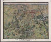
- Beinecke Rare Book and Manuscript Library > Perspective view of Gettysburg National Military Park / drawn under the direction of the Gettysburg National Park Commission, Colonel John P. Nicholson, Chairman, Major Charles A. Richardson, Commissioner. Drawing made February, 1919, by Lieut.-Colonel E.
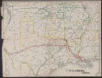
- Published / Created:
- 1880?]
- Call Number:
- 796gme 1880
- Container / Volume:
- BRBL_00531
- Image Count:
- 1
- Resource Type:
- Maps, Atlases & Globes
- Found in:
- Beinecke Rare Book and Manuscript Library > Map of the the Texas & Pacific Railway and connections.
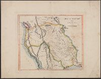
- Creator:
- Blake, Jacob Edmund, 1811 or 12-1846
- Published / Created:
- 1842?]
- Call Number:
- 796fab Sa13 1842E
- Container / Volume:
- BRBL_00530
- Image Count:
- 1
- Resource Type:
- Maps, Atlases & Globes
- Found in:
- Beinecke Rare Book and Manuscript Library > Part of the boundary between the United States and Texas, north of Sabine River from the 39th [i.e. 36th] to the 72nd mile mound / drawn from the notes of survey and copied for the use of the commissioners under the Convention of 25th April 1838 by J. Edm
- Creator:
- Carey, Mathew, 1760-1839
- Published / Created:
- 1814]
- Call Number:
- 80 1814D
- Container / Volume:
- BRBL_00532
- Image Count:
- 1
- Resource Type:
- Maps, Atlases & Globes
- Found in:
- Beinecke Rare Book and Manuscript Library > Missouri Territory formerly Louisiana / Lewis, del. ; Bower, sc.
- Creator:
- Blake, Jacob Edmund, 1811 or 12-1846
- Published / Created:
- 1842?]
- Call Number:
- 796fab Sa13 1842D
- Container / Volume:
- BRBL_00530
- Image Count:
- 1
- Resource Type:
- Maps, Atlases & Globes
- Found in:
- Beinecke Rare Book and Manuscript Library > Part of the boundary between the United States and Texas, from Sabine River northward to the 36th mile mound / drawn from the notes of survey and copied for the use of the commissioners under the Convention of 25th April 1838, by J. Edm.d Blake 1st Lieut.
- Published / Created:
- 1860?]
- Call Number:
- 796gme 1860
- Container / Volume:
- BRBL_00531
- Image Count:
- 1
- Resource Type:
- Maps, Atlases & Globes
- Found in:
- Beinecke Rare Book and Manuscript Library > A geographically correct map of the Red River, Sabine & Western Railway (under construction) and connections : showing distribution of pine forests (compiled from maps of U.S. government), also location of coal, iron, and oil deposits.
- Published / Created:
- 1879?]
- Call Number:
- 825 K134 1879
- Container / Volume:
- BRBL_00574
- Image Count:
- 1
- Resource Type:
- Maps, Atlases & Globes
- Found in:
- Beinecke Rare Book and Manuscript Library > Riverview, Wyandott County, Kansas / surveyed April 2nd 1879 by Dan'l OFlaherty, civil eng'r. Kansas City and surroundings / compiled and drawn by D.M. Smith, Wyandott, Kansas ; Ramsey, Millett & Hudson, map engravers, Kns. City Mo.
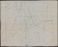
- Published / Created:
- 1922?]
- Call Number:
- 825ad An23 1922
- Container / Volume:
- BRBL_00575
- Image Count:
- 1
- Resource Type:
- Maps, Atlases & Globes
- Found in:
- Beinecke Rare Book and Manuscript Library > [Map of sections in townships 20 S and 21 S, and ranges 19 E and 20 E, Anderson County, Kansas] / F.S.T. 3/25/'22, Garnett, Kas.
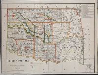
- Published / Created:
- 1889
- Call Number:
- 827 1889
- Container / Volume:
- BRBL_00577
- Image Count:
- 1
- Resource Type:
- Maps, Atlases & Globes
- Found in:
- Beinecke Rare Book and Manuscript Library > Indian territory / compiled under the direction of the Hon. John H. Oberly, Commissioner of Indian Affairs, by C.A. Maxwell ; John Olberg, draftsman.
- Creator:
- Hunnius, Ado
- Published / Created:
- 1876
- Call Number:
- 825gmb L487 1876
- Container / Volume:
- BRBL_00576
- Image Count:
- 1
- Resource Type:
- Maps, Atlases & Globes
- Found in:
- Beinecke Rare Book and Manuscript Library > Plan of the city of Leavenworth, Kansas / by Ado Hunnius.
- Published / Created:
- 188-?]
- Call Number:
- 825 K134 188X
- Container / Volume:
- BRBL_00574
- Image Count:
- 1
- Resource Type:
- Maps, Atlases & Globes
- Found in:
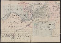
- Beinecke Rare Book and Manuscript Library > Map of the vicinity of Kansas City in Kansas and Missouri / compliments of H.C. Lloyd & Co., real estate brokers and builders ... Kansas City, Mo. ; MacCormac eng. Phila.
- Published / Created:
- 1882
- Call Number:
- 831 J89 1882
- Container / Volume:
- BRBL_00580
- Image Count:
- 1
- Resource Type:
- Maps, Atlases & Globes
- Found in:
- Beinecke Rare Book and Manuscript Library > Map of Judith Basin, Montana Ter. / Northern Transcontinental Survey, Raphael Pumpelly, director ; Department of Topography, A.D. Wilson, chief topographer ; lettering by F.D. Owen.
- Creator:
- Woodruff, Thomas Mayhew, d. 1899
- Published / Created:
- 187-?]
- Call Number:
- 831 1878B
- Container / Volume:
- BRBL_00579
- Image Count:
- 1
- Resource Type:
- Maps, Atlases & Globes
- Found in:
- Beinecke Rare Book and Manuscript Library > Map showing a portion of the marches of troops under Genl. N.A. Miles command 1876-1878 / drawn by Thom. M. Woodruff, Lt. 5th Inftry A.A.D.C., March 1st 1878.
- Creator:
- Villavicencio, Manuel, 1822-1871
- Published / Created:
- 1858
- Call Number:
- 99 1858
- Container / Volume:
- BRBL_00679
- Image Count:
- 1
- Resource Type:
- Maps, Atlases & Globes
- Found in:
- Beinecke Rare Book and Manuscript Library > Carta corografica de la republica del Ecuador / Manuel Villavicencio ; lit. é imp. de F. Mayer y Ca.
- Creator:
- United States. Post Office Dept
- Published / Created:
- 1910
- Call Number:
- 766gmd T57 1912
- Container / Volume:
- BRBL_00475A
- Image Count:
- 1
- Resource Type:
- Maps, Atlases & Globes
- Found in:
- Beinecke Rare Book and Manuscript Library > Map of Tolland County, Connecticut, showing rural delivery service / Post Office Department.
- Published / Created:
- 19--?]
- Call Number:
- 71ED 1850
- Container / Volume:
- BRBL_00371
- Image Count:
- 1
- Resource Type:
- Maps, Atlases & Globes
- Found in:
- Beinecke Rare Book and Manuscript Library > [Map of Indian tribes of North America].
- Creator:
- Massa, Isaac, 1587-1635
- Published / Created:
- ca. 1680]
- Call Number:
- 352 1630
- Container / Volume:
- BRBL_00722
- Image Count:
- 1
- Resource Type:
- Maps, Atlases & Globes
- Found in:
- Beinecke Rare Book and Manuscript Library > Moscoviae pars australis / auctore Isaaco Maβa.
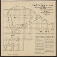
- Published / Created:
- 1885?]
- Call Number:
- 832gma Sn13 1885
- Container / Volume:
- BRBL_00583
- Image Count:
- 1
- Resource Type:
- Maps, Atlases & Globes
- Found in:
- Beinecke Rare Book and Manuscript Library > Map showing location of the Snake River Water Co.'s canals and lands of the International Immigrant Union capable of irrigation, in Bingham Co., Idaho Territory / Matthews, Northrup & Co., engravers and printers.
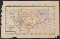
- Creator:
- Medary, Jacob
- Published / Created:
- 1882
- Call Number:
- 831gme 1882
- Container / Volume:
- BRBL_00581
- Image Count:
- 1
- Resource Type:
- Maps, Atlases & Globes
- Found in:
- Beinecke Rare Book and Manuscript Library > Montana / compiled from the latest official records and other sources by Jacob Medary.
- Published / Created:
- 188-?]
- Call Number:
- 832 W155 1888
- Container / Volume:
- BRBL_00582
- Image Count:
- 1
- Resource Type:
- Maps, Atlases & Globes
- Found in:
- Beinecke Rare Book and Manuscript Library > Wallace.
- Published / Created:
- 1920
- Call Number:
- 766 W15 1920
- Container / Volume:
- BRBL_00474
- Image Count:
- 1
- Resource Type:
- Maps, Atlases & Globes
- Found in:
- Beinecke Rare Book and Manuscript Library > Map of Gaylord Farm, Wallingford, Conn. / surveyed by H.E. Phelps.
- Published / Created:
- 1860?]
- Call Number:
- 40 V867 1860D
- Container / Volume:
- BRBL_00227
- Image Count:
- 1
- Resource Type:
- Maps, Atlases & Globes
- Found in:
- Beinecke Rare Book and Manuscript Library > Cne. di Voghera Fo. XLIV.
- Creator:
- Smith, M.L
- Published / Created:
- 1853, 1854.
- Call Number:
- 792 1855C
- Container / Volume:
- BRBL_00518
- Image Count:
- 1
- Resource Type:
- Maps, Atlases & Globes
- Found in:
- Beinecke Rare Book and Manuscript Library > Map showing the different lines of survey across Florida for a canal between Espiritu Santo Bay and the St. Johns and Ocklawaha Rivers / by Lieut. M. L. Smith, Topog. Engrs., Lieut. F. T. Bryan, Topog. Engrs. and A. E. Drake, C. Engr.
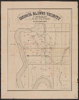
- Published / Created:
- 186-?]
- Call Number:
- 815ad C832 1860
- Container / Volume:
- BRBL_00561
- Image Count:
- 1
- Resource Type:
- Maps, Atlases & Globes
- Found in:
- Beinecke Rare Book and Manuscript Library > Council Bluffs vicinity / A. Cochran, dealer in lands, lots and land warrants.
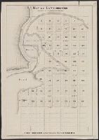
- Published / Created:
- 187-?]
- Call Number:
- 814 L248 1875
- Container / Volume:
- BRBL_00558
- Image Count:
- 1
- Resource Type:
- Maps, Atlases & Globes
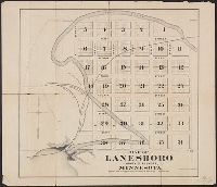
- Found in:
- Beinecke Rare Book and Manuscript Library > Map of Lanesboro, county of Fillmore, Minnesota : first addition to the village of Lanesboro.
- Published / Created:
- 1868?]
- Call Number:
- 814 L248 1868
- Container / Volume:
- BRBL_00558
- Image Count:
- 1
- Resource Type:
- Maps, Atlases & Globes
- Found in:
- Beinecke Rare Book and Manuscript Library > Map of Lanesboro, county of Fillmore, Minnesota.
- Published / Created:
- 1847?]
- Call Number:
- 815fcm 1847
- Container / Volume:
- BRBL_00561
- Image Count:
- 1
- Resource Type:
- Maps, Atlases & Globes
- Found in:
- Beinecke Rare Book and Manuscript Library > Sketch of the public surveys in Iowa.
- Published / Created:
- 1891]
- Call Number:
- 814gme 1891
- Container / Volume:
- BRBL_00559
- Image Count:
- 1
- Resource Type:
- Maps, Atlases & Globes
- Found in:
- Beinecke Rare Book and Manuscript Library > Map showing lands belonging to the St. Paul and Duluth Railroad Company, June 30th 1891 / Ralph Martin, del.
- Published / Created:
- 1841?]
- Call Number:
- 815 N171 1841
- Container / Volume:
- BRBL_00560
- Image Count:
- 1
- Resource Type:
- Maps, Atlases & Globes
- Found in:
- Beinecke Rare Book and Manuscript Library > Plat of the town of Nashville.
- Creator:
- Russel, Andrew F
- Published / Created:
- 185-?]
- Call Number:
- 815 D273 1850
- Container / Volume:
- BRBL_00560
- Image Count:
- 1
- Resource Type:
- Maps, Atlases & Globes
- Found in:
- Beinecke Rare Book and Manuscript Library > Map of Davenport and its vicinity, Iowa / by Andrew F. Rufsel.
- Published / Created:
- 186-?]
- Call Number:
- 815ad C832 1860
- Container / Volume:
- BRBL_00561
- Image Count:
- 1
- Resource Type:
- Maps, Atlases & Globes
- Found in:
- Beinecke Rare Book and Manuscript Library > Council Bluffs vicinity / A. Cochran, dealer in lands, lots and land warrants.
- Creator:
- Featherstonhaugh, George William, 1780-1866
- Published / Created:
- 1835]
- Call Number:
- 814 M667 1835
- Container / Volume:
- BRBL_00558
- Image Count:
- 1
- Resource Type:
- Maps, Atlases & Globes
- Found in:
- Beinecke Rare Book and Manuscript Library > A reconnoissance of the Minnay Sotor Watapāh; or St. Peter's River to its sources / made in the year 1835 by G.W. Featherstonhaugh, U.S. geologist.
- Published / Created:
- 183-?]
- Call Number:
- 816 Ir6 1837A
- Container / Volume:
- BRBL_00562
- Image Count:
- 1
- Resource Type:
- Maps, Atlases & Globes
- Found in:
- Beinecke Rare Book and Manuscript Library > Iron Mountain City.
- Published / Created:
- 1893?]
- Call Number:
- 88 M57 1893
- Container / Volume:
- BRBL_00647
- Image Count:
- 1
- Resource Type:
- Maps, Atlases & Globes
- Found in:
- Beinecke Rare Book and Manuscript Library > [Map of railroads in Mexico City Region].
- Creator:
- Walling, Henry Francis, 1825-1888
- Published / Created:
- 1856
- Call Number:
- 764 D255 1856
- Container / Volume:
- BRBL_00457
- Image Count:
- 1
- Resource Type:
- Maps, Atlases & Globes
- Found in:
- Beinecke Rare Book and Manuscript Library > Map of the town of Dartmouth, Bristol County Mass. : made by order of the town / under the direction of H.F. Walling, sup. of the state map.
- Published / Created:
- 1850?]
- Call Number:
- 796 St24 1850
- Container / Volume:
- BRBL_00528
- Image Count:
- 1
- Resource Type:
- Maps, Atlases & Globes
- Found in:
- Beinecke Rare Book and Manuscript Library > Town of St. Mary's, Refugio Co., Texas.
- Published / Created:
- 1837?]
- Call Number:
- 796 H37 1837
- Container / Volume:
- BRBL_00527A
- Image Count:
- 1
- Resource Type:
- Maps, Atlases & Globes
- Found in:
- Beinecke Rare Book and Manuscript Library > Survey of 5 leagues of land belonging to Wm P. Harris & others / lith. of P. Snell.
- Creator:
- Blake, Jacob Edmund, 1811 or 12-1846
- Published / Created:
- 1842?]
- Call Number:
- 796fab Sa13 1842F
- Container / Volume:
- BRBL_00530
- Image Count:
- 1
- Resource Type:
- Maps, Atlases & Globes
- Found in:
- Beinecke Rare Book and Manuscript Library > Part of the boundary between the United States and Texas, north of the Sabine River from the 72nd mile mound to Red River / drawn from the notes of survey and copied for the use of the commissioners under the Convention of 25th April, 1838 by J. Edm.d Bla
- Published / Created:
- 187-?]
- Call Number:
- 825gme 1870
- Container / Volume:
- BRBL_00576
- Image Count:
- 1
- Resource Type:
- Maps, Atlases & Globes
- Found in:
- Beinecke Rare Book and Manuscript Library > Map of eastern Kansas : showing the lines of the Mo.R.F.S. & G.R.R. and connections.
- Published / Created:
- 1874?]
- Call Number:
- 825 1874
- Container / Volume:
- BRBL_00573
- Image Count:
- 1
- Resource Type:
- Maps, Atlases & Globes
- Found in:
- Beinecke Rare Book and Manuscript Library > Sectional map of the Pottawattomie Reserve lands : remaining unsold July 1st 1874.
- Creator:
- Union Pacific Railroad Company
- Published / Created:
- 1867?]
- Call Number:
- 824 Om1 1867
- Container / Volume:
- BRBL_00571
- Image Count:
- 1
- Resource Type:
- Maps, Atlases & Globes
- Found in:
- Beinecke Rare Book and Manuscript Library > Map to accompany report of J.L. Williams on the bridging of the Missouri River / Union Pacific Rail Road.
- Creator:
- Jensen, M. K
- Published / Created:
- c1939.
- Call Number:
- 827 B284 1939
- Container / Volume:
- BRBL_00577
- Image Count:
- 1
- Resource Type:
- Maps, Atlases & Globes
- Found in:
- Beinecke Rare Book and Manuscript Library > City of Bartlesville, Oklahoma / compiled and drawn by M.K. Jensen.
- Creator:
- Lawrence, C. M., surveyor
- Published / Created:
- 189-?]
- Call Number:
- 827 W44 189X
- Container / Volume:
- BRBL_00578
- Image Count:
- 1
- Resource Type:
- Maps, Atlases & Globes
- Found in:
- Beinecke Rare Book and Manuscript Library > Plan of Weleetka, Creek Nation, Indian Tery. / C.M. Lawrence, surveyor.
- Published / Created:
- 1946?]
- Call Number:
- 825cbf F778 1943
- Container / Volume:
- BRBL_00575
- Image Count:
- 1
- Resource Type:
- Maps, Atlases & Globes
- Found in:
- Beinecke Rare Book and Manuscript Library > Tactical map, Fort Riley & vicinity / horizontal and vertical control by U.S.G.S. & U.S.C. & G.S. ; aerial photography by Flight C 1st Photographic Squadron, A.C. Dec. 1940 ; multiplex mapping & drafting by the District Engineer, U.S.E.D. Little Rock, Ark