Skip to search
Skip to main content
Skip to first result
Search
You Searched For
Language
English
Publication Place
[S.l. :
New Search
Search Results
Creator:
Published / Created:
c1939.
Call Number:
827 B284 1939
Container / Volume:
BRBL_00577
Image Count:
1
Resource Type:
Maps, Atlases & Globes
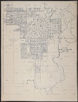
Description:
Copyright: M.K. Jensen. and Shows "original town" and additions.
Publisher:
s.n.],
Subject (Geographic):
Bartlesville (Okla.)--Maps
Found in:
Beinecke Rare Book and Manuscript Library > City of Bartlesville, Oklahoma / compiled and drawn by M.K. Jensen.
Creator:
Published / Created:
1877]
Call Number:
844 Sa593 1877
Container / Volume:
BRBL_00610
Image Count:
1
Resource Type:
Maps, Atlases & Globes
Description:
Indexed., Library's copy annotated in ink., and Relief shown by hachures.
Publisher:
lith. Britton, Rey & Co.) and s.n.,
Subject (Geographic):
Santa Cruz (Calif.)--Maps
Found in:
Beinecke Rare Book and Manuscript Library > City of Santa Cruz, California, 1877 / compiled by Edwin Shepard.
Creator:
Published / Created:
19--?]
Call Number:
73 1814
Container / Volume:
BRBL_00374
Image Count:
1
Resource Type:
Maps, Atlases & Globes
Description:
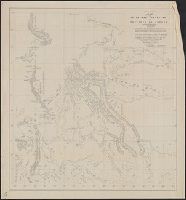
"This map made for the North West Company in 1813 and 1814 ....", Covers British Columbia, portions of Alberta, and U.S. Pacific Northwest., Includes text., Relief shown by hachures., and Reprint of 1814[?] map.
Publisher:
s.n.,
Subject (Geographic):
Canada, Western--Maps and Northwest, Pacific--Maps
Subject (Name):
Canada. Office of the Surveyor General
Found in:
Beinecke Rare Book and Manuscript Library > Copy of a portion of map of the North-West territory of the Province of Canada : from actual survey during the years 1798 to 1812 / by David Thompson.
Published / Created:
186-?]
Call Number:
815ad C832 1860
Container / Volume:
BRBL_00561
Image Count:
1
Resource Type:
Maps, Atlases & Globes
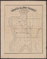
Description:
Library's copies annotated in ink to indicate railroads, landowners, and lots., Relief shown by hachures., and Shows township sections and landowners.
Publisher:
s.n.,
Subject (Name):
Cochran, A and Mendel, Edward, 1827-1884
Subject (Topic):
Real property--Iowa--Council Bluffs Region--Maps
Found in:
Beinecke Rare Book and Manuscript Library > Council Bluffs vicinity / A. Cochran, dealer in lands, lots and land warrants.
Published / Created:
186-?]
Call Number:
815ad C832 1860
Container / Volume:
BRBL_00561
Image Count:
1
Resource Type:
Maps, Atlases & Globes
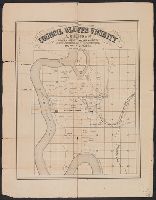
Description:
Library's copies annotated in ink to indicate railroads, landowners, and lots., Relief shown by hachures., and Shows township sections and landowners.
Publisher:
s.n.,
Subject (Name):
Cochran, A and Mendel, Edward, 1827-1884
Subject (Topic):
Real property--Iowa--Council Bluffs Region--Maps
Found in:
Beinecke Rare Book and Manuscript Library > Council Bluffs vicinity / A. Cochran, dealer in lands, lots and land warrants.
Published / Created:
1847 or 1848?]
Call Number:
816fcm 1847
Container / Volume:
BRBL_00563
Image Count:
1
Resource Type:
Maps, Atlases & Globes
Description:
"F.R. Conway, Surveyor of the public lands in the states of Illinois and Missouri.", At head of title: (H)., Date inferred from reference in text to appropriations of March 1847 and fiscal year 1848-9 estimates., Includes text., and Shows townships and sections.
Publisher:
s.n.,
Subject (Geographic):
Missouri--Maps
Subject (Name):
Conway, F. R
Found in:
Beinecke Rare Book and Manuscript Library > Diagram of the state of Missouri.
Published / Created:
1874]
Call Number:
75eha 1873
Image Count:
1
Resource Type:
Maps, Atlases & Globes
Description:
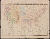
Prime meridians: Washington, D.C. and Greenwich. and Relief shown by hachures.
Publisher:
s.n.,
Subject (Geographic):
United States--Maps
Subject (Name):
Episcopal Church--Missions--United States--Maps
Subject (Topic):
Missions--United States--Maps
Found in:
Beinecke Rare Book and Manuscript Library > Domestic missionary map, Protestant Episcopal Church.
Published / Created:
1945?]
Call Number:
48g 1945
Container / Volume:
BRBL_00264
Image Count:
1
Resource Type:
Maps, Atlases & Globes
Description:
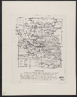
Photocopy.
Publisher:
s.n.,
Subject (Geographic):
Greece--Maps
Found in:
Beinecke Rare Book and Manuscript Library > Economic map of Greece.
Published / Created:
1910?]
Call Number:
11hcf 1919B-6
Container / Volume:
BRBL_00010S
Image Count:
1
Resource Type:
Maps, Atlases & Globes
Description:
Ms. notes in red and yellow ink, outlining "Ceded Territory," and areas inhabited by different ethnic groups. "Ceded Territory" may refer to lands acquired by Russia at the end of the Russo-Turkish War of 1877-1878.
Publisher:
s.n.,
Subject (Geographic):
Caucasus--Maps
Subject (Topic):
Ethnology--Caucasus--Maps
Found in:
Beinecke Rare Book and Manuscript Library > Ethnography [of Caucasus Region].
Published / Created:
19--?]
Call Number:
11hcf 1919B-17
Container / Volume:
BRBL_00010O
Image Count:
2
Resource Type:
Maps, Atlases & Globes
Description:
2 copies. Copy 2 has Ms. notes of later political boundaries., Copy 1 in two pieces., and Relief shown by hachures.
Publisher:
s.n.,
Subject (Geographic):
Europe--Maps
Subject (Topic):
World War, 1914-1918--Europe--Maps
Found in:
Beinecke Rare Book and Manuscript Library > Europe.
Branch:v1.61.6 ,Deployed:2024-06-12T09:55:36-04:00