Skip to search
Skip to main content
Skip to first result
Search
You Searched For
Language
English
Publication Place
[S.l. :
New Search
Search Results
Published / Created:
19--?]
Call Number:
11hcf 1919B-17
Container / Volume:
BRBL_00010O
Image Count:
1
Resource Type:
Maps, Atlases & Globes
Description:
2 copies. Copy 2 has Ms. notes of later political boundaries. and Relief shown by hachures.
Publisher:
s.n.,
Subject (Geographic):
Europe--Maps
Subject (Topic):
World War, 1914-1918--Europe--Maps
Found in:
Beinecke Rare Book and Manuscript Library > Europe.
Published / Created:
1944?]
Call Number:
11hd 1944M-3
Container / Volume:
BRBL_00010ZE
Image Count:
2
Resource Type:
Maps, Atlases & Globes
Alternative Title:
Defences
Description:
"Information as at 12 May 44 ; Top Secret until issued for briefing ground troops thereafter Secret".
Publisher:
s.n.,
Subject (Geographic):
Manche (France)--Maps
Found in:
Beinecke Rare Book and Manuscript Library > France, 1:12,500. Sheet no. 73, Foucarville.
Published / Created:
1944?]
Call Number:
11hd 1944M-2
Container / Volume:
BRBL_00010ZE
Image Count:
2
Resource Type:
Maps, Atlases & Globes
Alternative Title:
Defences
Description:
"Stop Press edition of 20 May 1944 ; Bigot Copy No. 437 ; Information... 19 May 44 ; Top Secret until issued for briefing ground troops thereafter Secret".
Publisher:
s.n.,
Subject (Geographic):
Manche (France)--Maps
Found in:
Beinecke Rare Book and Manuscript Library > France, 1:25,000. Sheet no. 31/18 N.E., Ste. Mère Église.
Published / Created:
1944?]
Call Number:
11hd 1944M-1
Container / Volume:
BRBL_00010ZE
Image Count:
2
Resource Type:
Maps, Atlases & Globes
Alternative Title:
Defences
Description:
"Information as at May 44 ; Top Secret until issued for briefing ground troops thereafter Secret".
Publisher:
s.n.,
Subject (Geographic):
Manche (France)--Maps
Found in:
Beinecke Rare Book and Manuscript Library > France, 1:25,000. Sheet no. 31/20 S.E., Montebourg.
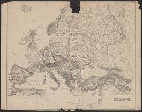
Published / Created:
1919]
Call Number:
11hcf 1919B-21
Container / Volume:
BRBL_00010P
Image Count:
1
Resource Type:
Maps, Atlases & Globes
Publisher:
s.n.,
Subject (Geographic):
Europe, Western--Maps
Found in:
Beinecke Rare Book and Manuscript Library > France.
Creator:
Published / Created:
1855
Call Number:
895 1855
Container / Volume:
BRBL_00659
Image Count:
1
Resource Type:
Maps, Atlases & Globes
Description:
Insets: Vista de ma Mina de Corbou descubierta per F. Ferrer en Choutáles -- Plan y vista de las Minas Luigalpa en Choudales -- Plan de hatogrande en Choudales., Prime meridians: Washington - Greenwich., and Relief shown by hachures; depths shown by isolines.
Publisher:
s.n.],
Subject (Geographic):
Nicaragua--Maps
Found in:
Beinecke Rare Book and Manuscript Library > Geographical map of the Republic of Nicaragua : with three plans and views / by Fermin Ferrer, Governor of the Western Dept.
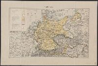
Published / Created:
1919]
Call Number:
11hcf 1919B-16
Container / Volume:
BRBL_00010O
Image Count:
1
Resource Type:
Maps, Atlases & Globes
Description:
Ms. notes of changed political boundaries following the first World War.
Publisher:
s.n.,
Subject (Geographic):
Europe, Central--Maps and Germany--Maps
Subject (Topic):
Boundaries--Europe, Central--Maps and World War, 1914-1918--Europe, Central--Maps
Found in:
Beinecke Rare Book and Manuscript Library > Germany.
Published / Created:
1919]
Call Number:
11hcf 1919B-22
Container / Volume:
BRBL_00010P
Image Count:
1
Resource Type:
Maps, Atlases & Globes
Publisher:
s.n.,
Subject (Geographic):
Europe, Central--Maps
Found in:
Beinecke Rare Book and Manuscript Library > Germany.
Creator:
Published / Created:
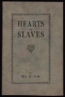
19--?]
Call Number:
JWJ Zan St307 900H
Image Count:
24
Description:
In verse., Includes manuscript corrections of typographical errors., and Paperbound.
Publisher:
s.n.,
Found in:
Beinecke Rare Book and Manuscript Library > Hearts of slaves / by Elihu Hill Steele.
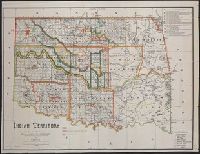
Published / Created:
1889
Call Number:
827 1889
Container / Volume:
BRBL_00577
Image Count:
1
Resource Type:
Maps, Atlases & Globes
Description:
Relief shown by hachures. and Shows the lands occupied by various tribes and includes details about land transfers and cessions.
Publisher:
s.n.],
Subject (Geographic):
Oklahoma--Administrative and political divisions--Maps
Subject (Name):
A. Hoen & Co, Maxwell, Charles A, Olberg, John, and United States. Office of Indian Affairs
Subject (Topic):
Indians of North America--Oklahoma--Maps
Found in:
Beinecke Rare Book and Manuscript Library > Indian territory / compiled under the direction of the Hon. John H. Oberly, Commissioner of Indian Affairs, by C.A. Maxwell ; John Olberg, draftsman.
Branch:v1.61.6 ,Deployed:2024-06-12T09:55:33-04:00