Skip to search
Skip to main content
Skip to first result
Search
You Searched For
Date
1938 - 1938
Repository
Beinecke Rare Book and Manuscript Library
Publication Place
[S.l. :
Date Created
1938
New Search
Search Results
Creator:
Published / Created:
19--?]
Call Number:
71 1593
Container / Volume:
BRBL_00359
Image Count:
1
Resource Type:
Maps, Atlases & Globes
Description:
Facsimile of 1593 map., Includes ill. and text., and Relief shown pictorially.
Publisher:
Alcuin Society?,
Subject (Geographic):
North America--Maps--Early works to 1800--Facsimiles
Subject (Name):
Alcuin Society
Subject (Topic):
Maps--Early works to 1800--Facsimiles
Found in:
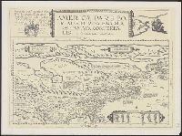
Beinecke Rare Book and Manuscript Library > Americae pars borealis, Florida, Baccalaos, Canada, Corterealis / A Cornelio de Iudaeis in luce edita.
Published / Created:
19--?].
Call Number:
38 C118 1960
Container / Volume:
BRBL_00156
Image Count:
1
Resource Type:
Maps, Atlases & Globes
Publisher:
s.n.,
Subject (Geographic):
Cagnes-sur-Mer (France)--Maps
Found in:
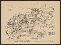
Beinecke Rare Book and Manuscript Library > Cagnes Fortin Médiéval : Plan promenade / édité par les Amis du Vieux Cagnes.
Creator:
Published / Created:
19--?]
Call Number:
71 1683
Container / Volume:
BRBL_00360
Image Count:
1
Resource Type:
Maps, Atlases & Globes
Description:
Photocopy of map from Hennepin's Description de la Louisiane. Paris, 1683. and Relief shown pictorially.
Publisher:
s.n.,
Subject (Geographic):
North America--Maps
Subject (Name):
Guérard, Nicholas and Hennepin, Louis, 17th cent. Description de la Louisiane, nouvellement decouverte au sud' oüest de la Nouvelle France, par ordre du roy
Found in:
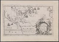
Beinecke Rare Book and Manuscript Library > Carte de la Nouvelle France : et de la Louisiane nouvellement decouverte dediee au roy l'an 1683 / par le Reverend Pere Louis Hennepin, missionaire recollect et notaire apostoliquen ; N.Guerard ... et fecit.
Creator:
Published / Created:
19--?]
Call Number:
73 1814
Container / Volume:
BRBL_00374
Image Count:
1
Resource Type:
Maps, Atlases & Globes
Description:
"This map made for the North West Company in 1813 and 1814 ....", Covers British Columbia, portions of Alberta, and U.S. Pacific Northwest., Includes text., Relief shown by hachures., and Reprint of 1814[?] map.
Publisher:
s.n.,
Subject (Geographic):
Canada, Western--Maps and Northwest, Pacific--Maps
Subject (Name):
Canada. Office of the Surveyor General
Found in:
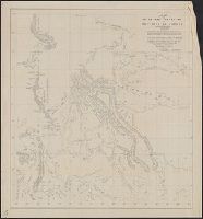
Beinecke Rare Book and Manuscript Library > Copy of a portion of map of the North-West territory of the Province of Canada : from actual survey during the years 1798 to 1812 / by David Thompson.
Published / Created:
19--?]
Call Number:
11hcf 1919B-17
Container / Volume:
BRBL_00010O
Image Count:
2
Resource Type:
Maps, Atlases & Globes
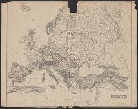
Description:
2 copies. Copy 2 has Ms. notes of later political boundaries., Copy 1 in two pieces., and Relief shown by hachures.
Publisher:
s.n.,
Subject (Geographic):
Europe--Maps
Subject (Topic):
World War, 1914-1918--Europe--Maps
Found in:
Beinecke Rare Book and Manuscript Library > Europe.
Published / Created:
19--?]
Call Number:
11hcf 1919B-17
Container / Volume:
BRBL_00010O
Image Count:
1
Resource Type:
Maps, Atlases & Globes
Description:
2 copies. Copy 2 has Ms. notes of later political boundaries. and Relief shown by hachures.
Publisher:
s.n.,
Subject (Geographic):
Europe--Maps
Subject (Topic):
World War, 1914-1918--Europe--Maps
Found in:
Beinecke Rare Book and Manuscript Library > Europe.
Creator:
Published / Created:
19--?]
Call Number:
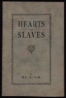
JWJ Zan St307 900H
Image Count:
24
Description:
In verse., Includes manuscript corrections of typographical errors., and Paperbound.
Publisher:
s.n.,
Found in:
Beinecke Rare Book and Manuscript Library > Hearts of slaves / by Elihu Hill Steele.
Creator:
Published / Created:
19--?]
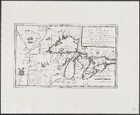
Call Number:
71 1680A
Container / Volume:
BRBL_00360
Image Count:
1
Resource Type:
Maps, Atlases & Globes
Abstract:
Shows Great Lakes region of North America.
Description:
"All, illustriss; et eccellentiss: S. Zaccaria Bernardi, fư dell ́Ecc. S. Francesco." and Photocopy of 17th cent. map.
Publisher:
s.n.,
Subject (Geographic):
Great Lakes Region (North America)--Maps
Subject (Name):
Bernardi, Zaccaria
Found in:
Beinecke Rare Book and Manuscript Library > La Louisiana, parte settentrionalle : scoperta sotta la protettione di Luigi XIV, Ré di Francia, etc. / descritta, e dedicata, dal P. Cosmografo Coronelli.
Published / Created:
19--?]
Call Number:
574 1930
Container / Volume:
BRBL_00311
Image Count:
1
Resource Type:
Maps, Atlases & Globes
Description:
Includes legend., Inset shows railroads in China, Korea, Japan, and Taiwan., Relief shown by shading., and Shows part of Manchuria and Russia.
Publisher:
s.n.,
Subject (Geographic):
Korea--Maps
Found in:
Beinecke Rare Book and Manuscript Library > Map of Chosen (Korea).
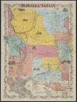
Creator:
Published / Created:
19--?]
Call Number:
824 1854B
Container / Volume:
BRBL_00570
Image Count:
1
Resource Type:
Maps, Atlases & Globes
Alternative Title:
Map of the territory acquired from Mexico by the Gadsden Treaty, 1854.
Description:
Covers Nebraska extending to the Canadian border and westward to Oregon and Kansas including present day Colorado., Includes ill. and insets of United States and "Map of the territory acquired from Mexico by the Gadsden Treaty, 1854.", and Relief shown by hachures.
Publisher:
s.n.,
Subject (Geographic):
Kansas--Maps, Nebraska--Maps, and West (U.S.)--Maps
Subject (Name):
Mexico.--Treaties, etc.--United States,--1853 Dec. 30--Maps
Found in:
Beinecke Rare Book and Manuscript Library > Nebraska and Kansas.
Branch:v1.61.6 ,Deployed:2024-06-12T09:55:31-04:00