Search
You Searched For
Search Results
- Published / Created:
- 1860?]
- Call Number:
- 796gme 1860
- Container / Volume:
- BRBL_00531
- Image Count:
- 1
- Resource Type:
- Maps, Atlases & Globes
- Found in:
- Beinecke Rare Book and Manuscript Library > A geographically correct map of the Red River, Sabine & Western Railway (under construction) and connections : showing distribution of pine forests (compiled from maps of U.S. government), also location of coal, iron, and oil deposits.
- Published / Created:
- ca 1810]
- Call Number:
- 773 J487 1810
- Container / Volume:
- BRBL_00496
- Image Count:
- 1
- Resource Type:
- Maps, Atlases & Globes
- Found in:
- Beinecke Rare Book and Manuscript Library > A map of that part of the town of Jersey, commonly called Aharsimus.
- Creator:
- Parker, John Henry, 1806-1884
- Published / Created:
- 1882]
- Call Number:
- 40 R66 1882
- Container / Volume:
- BRBL_00219
- Image Count:
- 1
- Resource Type:
- Maps, Atlases & Globes
- Found in:
- Beinecke Rare Book and Manuscript Library > A plan of Rome, ancient and modern [cartographic material] : with indications of the ancient walls, streets and gates according to Pliny / by John Henry Parker.
- Creator:
- Featherstonhaugh, George William, 1780-1866
- Published / Created:
- 1835]
- Call Number:
- 814 M667 1835
- Container / Volume:
- BRBL_00558
- Image Count:
- 1
- Resource Type:
- Maps, Atlases & Globes
- Found in:
- Beinecke Rare Book and Manuscript Library > A reconnoissance of the Minnay Sotor Watapāh; or St. Peter's River to its sources / made in the year 1835 by G.W. Featherstonhaugh, U.S. geologist.
- Creator:
- Arkansas. Surveyor's Office
- Published / Created:
- 1855]
- Call Number:
- 818 1855B
- Container / Volume:
- BRBL_00565
- Image Count:
- 1
- Resource Type:
- Maps, Atlases & Globes
- Found in:
- Beinecke Rare Book and Manuscript Library > Arkansas / Surveyor's Office Little Rock Oct. 18th 1855. Henry M. Rector, Sur. Genl. of Arks.
- Published / Created:
- 1880?]
- Call Number:
- 3627 B14 1880
- Image Count:
- 2
- Resource Type:
- Maps, Atlases & Globes
- Found in:
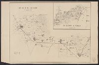
- Beinecke Rare Book and Manuscript Library > Baierbrunn.
- Published / Created:
- 1886
- Call Number:
- 44 1886
- Container / Volume:
- BRBL_00255
- Image Count:
- 2
- Resource Type:
- Maps, Atlases & Globes
- Found in:
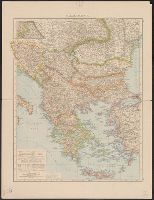
- Beinecke Rare Book and Manuscript Library > Balkanhalbinsel.
- Published / Created:
- 1859]
- Call Number:
- 40hc 1859J
- Container / Volume:
- BRBL_00231
- Image Count:
- 1
- Resource Type:
- Maps, Atlases & Globes
- Found in:
- Beinecke Rare Book and Manuscript Library > Battaglia del Volturno.
- Creator:
- Peseux, M
- Published / Created:
- 1864
- Call Number:
- 801hc N17 1864
- Container / Volume:
- BRBL_00541
- Image Count:
- 1
- Resource Type:
- Maps, Atlases & Globes
- Found in:
- Beinecke Rare Book and Manuscript Library > Battlefields in front of Nashville where the United States forces commanded by Major General Geo. H. Thomas defeated and routed the Rebel army under General Hood, December 15th & 16th 1864 / surveyed and drawn under the direction of Gen: Tower by M. Peseu
- Published / Created:
- 1870?]
- Call Number:
- 4073cbf 1870
- Container / Volume:
- BRBL_00237
- Image Count:
- 3
- Resource Type:
- Maps, Atlases & Globes
- Found in:
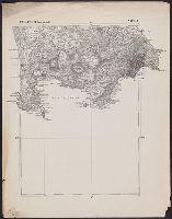
- Beinecke Rare Book and Manuscript Library > Campania, section of Pozzuoli, Napoli, to Castellammare.