Skip to search
Skip to main content
Skip to first result
Search
You Searched For
Resource Type
Maps, Atlases & Globes
Publication Place
[S.l. :
New Search
Search Results
Creator:
Published / Created:
1882]
Call Number:
40 R66 1882
Container / Volume:
BRBL_00219
Image Count:
1
Resource Type:
Maps, Atlases & Globes
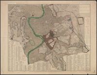
Description:
"Engraved by W. Harwood ... London." and ALS, signed, tipped in. Letter of transmittal to the Boston Athenaeum includes Parker's statement "I do not propose to publish it [the plan], but have made a few copies printed for private circulation only."
Publisher:
s.n.,
Subject (Geographic):
Rome (Italy)--Maps and Rome--Maps
Subject (Name):
Harwood, W
Found in:
Beinecke Rare Book and Manuscript Library > A plan of Rome, ancient and modern [cartographic material] : with indications of the ancient walls, streets and gates according to Pliny / by John Henry Parker.
Creator:
Published / Created:
1835]
Call Number:
814 M667 1835
Container / Volume:
BRBL_00558
Image Count:
1
Resource Type:
Maps, Atlases & Globes
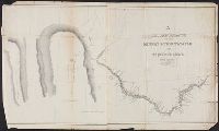
Alternative Title:
Chrrah tanka; the Great Hills or Coteau De Prairie. and Minnay shoshoh chrray; or Great Hills of the Missouri.
Description:
Includes Indian and French terms., Includes maps of "Minnay shoshoh chrray; or Great Hills of the Missouri," and "Chrrah tanka; the Great Hills or Coteau De Prairie.", Relief shown by hachures., and Shows points of interest and topography.
Publisher:
s.n.,
Subject (Geographic):
Minnesota River (S.D. and Minn.)--Maps
Found in:
Beinecke Rare Book and Manuscript Library > A reconnoissance of the Minnay Sotor Watapāh; or St. Peter's River to its sources / made in the year 1835 by G.W. Featherstonhaugh, U.S. geologist.
Published / Created:
1919?]
Call Number:
11hcf 1919B-29
Container / Volume:
BRBL_00010Q
Image Count:
1
Resource Type:
Maps, Atlases & Globes
Publisher:
s.n.,
Subject (Geographic):
Adriatic Coast (Balkan Peninsula)--Maps and Italy--Maps
Found in:
Beinecke Rare Book and Manuscript Library > Adriatic.
Published / Created:
1919?]
Call Number:
11hcf 1919B-45
Container / Volume:
BRBL_00010R
Image Count:
1
Resource Type:
Maps, Atlases & Globes
Publisher:
s.n.,
Subject (Geographic):
Albania--Maps
Found in:
Beinecke Rare Book and Manuscript Library > Albania.
Published / Created:
1900?]
Call Number:
475CBD 1900
Container / Volume:
BRBL_00262
Image Count:
1
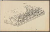
Resource Type:
Maps, Atlases & Globes
Description:
Bird's-eye view of Albania, showing topography and some towns. and Inset map of Italy, Central Europe, and the Balkan Peninsula.
Publisher:
s.n.,
Subject (Geographic):
Albania--Maps
Found in:
Beinecke Rare Book and Manuscript Library > Albania.
Creator:
Published / Created:
19--?]
Call Number:
71 1593
Container / Volume:
BRBL_00359
Image Count:
1
Resource Type:
Maps, Atlases & Globes
Description:
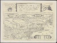
Facsimile of 1593 map., Includes ill. and text., and Relief shown pictorially.
Publisher:
Alcuin Society?,
Subject (Geographic):
North America--Maps--Early works to 1800--Facsimiles
Subject (Name):
Alcuin Society
Subject (Topic):
Maps--Early works to 1800--Facsimiles
Found in:
Beinecke Rare Book and Manuscript Library > Americae pars borealis, Florida, Baccalaos, Canada, Corterealis / A Cornelio de Iudaeis in luce edita.
Published / Created:
between 1722 and 1799?]
Call Number:
70 1722A
Container / Volume:
BRBL_00355
Image Count:
1
Resource Type:
Maps, Atlases & Globes
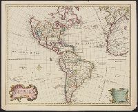
Description:
Includes text., Prime meridian: Ferro., Relief shown pictorially., Shows northwest coast in the form used in Guillaume De L'Isle's 1722 map of America. Cf. Wagner, H.R. Cartog. of the NW coast, p. 142., and Tooley refers to this map in Mapping of America, p. 13,
Publisher:
s.n.,
Subject (Geographic):
America--Maps--Early works to 1800
Subject (Name):
L'Isle, Guillaume de, 1675-1726 and L'Isle, Joseph Nicolas de, 1688-1768
Found in:
Beinecke Rare Book and Manuscript Library > Amerika.
Published / Created:
1919?]
Call Number:
11hcf 1919B-40
Image Count:
1
Resource Type:
Maps, Atlases & Globes
Publisher:
s.n.,
Subject (Geographic):
Caucasus--Maps and Turkey--Maps
Found in:
Beinecke Rare Book and Manuscript Library > Anatolia and Armenia.
Published / Created:
1919?]
Call Number:
11hcf 1919B-43
Image Count:
1
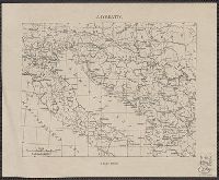
Resource Type:
Maps, Atlases & Globes
Description:
Lower left: 584a.
Publisher:
s.n.,
Subject (Geographic):
Croatia--Maps
Found in:
Beinecke Rare Book and Manuscript Library > Areas and population of Dalmatian Islands in 1900 : Official Austrian census.
Creator:
Published / Created:
1855]
Call Number:
818 1855B
Container / Volume:
BRBL_00565
Image Count:
1
Resource Type:
Maps, Atlases & Globes
Alternative Title:
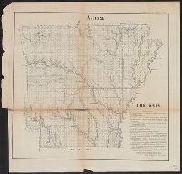
Senate executive document (United States. Congress. Senate) ; 34th Congress, 1st session, no. 1.
Description:
"A, (1 & 2)", "Sen. Ex. Doc. No. 1, 34th. Cong.: 1st Sess.", and Relief shown by hachures.
Publisher:
s.n.,
Subject (Geographic):
Arkansas--Surveys--Maps
Subject (Name):
A. Hoen & Co
Found in:
Beinecke Rare Book and Manuscript Library > Arkansas / Surveyor's Office Little Rock Oct. 18th 1855. Henry M. Rector, Sur. Genl. of Arks.
Branch:v1.61.8 ,Deployed:2024-06-20T11:14:55-04:00