Search
You Searched For
Search Results
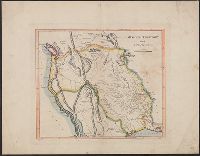
- Creator:
- Carey, Mathew, 1760-1839
- Published / Created:
- 1814]
- Call Number:
- 80 1814D
- Container / Volume:
- BRBL_00532
- Image Count:
- 1
- Resource Type:
- Maps, Atlases & Globes
- Description:
- Shows boundaries of Missouri Territory.
- Found in:
- Beinecke Rare Book and Manuscript Library > Missouri Territory formerly Louisiana / Lewis, del. ; Bower, sc.
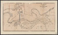
- Creator:
- Union Pacific Railroad Company
- Published / Created:
- 1867?]
- Call Number:
- 824 Om1 1867
- Container / Volume:
- BRBL_00571
- Image Count:
- 1
- Resource Type:
- Maps, Atlases & Globes
- Subject (Topic):
- Railroad bridges--Missouri River--Maps
- Found in:
- Beinecke Rare Book and Manuscript Library > Map to accompany report of J.L. Williams on the bridging of the Missouri River / Union Pacific Rail Road.
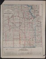
- Published / Created:
- 187-?]
- Call Number:
- 825gme 1870
- Container / Volume:
- BRBL_00576
- Image Count:
- 1
- Resource Type:
- Maps, Atlases & Globes
- Subject (Name):
- Missouri River, Fort Scott & Gulf
- Found in:
- Beinecke Rare Book and Manuscript Library > Map of eastern Kansas : showing the lines of the Mo.R.F.S. & G.R.R. and connections.
- Published / Created:
- 183-?]
- Call Number:
- 816 Ir6 1837A
- Container / Volume:
- BRBL_00562
- Image Count:
- 1
- Resource Type:
- Maps, Atlases & Globes
- Subject (Topic):
- Real property--Missouri--Iron Mountain
- Found in:
- Beinecke Rare Book and Manuscript Library > Iron Mountain City.
- Published / Created:
- 1847 or 1848?]
- Call Number:
- 816fcm 1847
- Container / Volume:
- BRBL_00563
- Image Count:
- 1
- Resource Type:
- Maps, Atlases & Globes
- Description:
- lands in the states of Illinois and Missouri."
- Subject (Geographic):
- Missouri--Maps
- Found in:
- Beinecke Rare Book and Manuscript Library > Diagram of the state of Missouri.
- Creator:
- Woodruff, Thomas Mayhew, d. 1899
- Published / Created:
- 187-?]
- Call Number:
- 831 1878B
- Container / Volume:
- BRBL_00579
- Image Count:
- 1
- Resource Type:
- Maps, Atlases & Globes
- Description:
- near Missouri and Yellowstone rivers in
- Found in:
- Beinecke Rare Book and Manuscript Library > Map showing a portion of the marches of troops under Genl. N.A. Miles command 1876-1878 / drawn by Thom. M. Woodruff, Lt. 5th Inftry A.A.D.C., March 1st 1878.
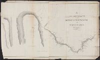
- Creator:
- Featherstonhaugh, George William, 1780-1866
- Published / Created:
- 1835]
- Call Number:
- 814 M667 1835
- Container / Volume:
- BRBL_00558
- Image Count:
- 1
- Resource Type:
- Maps, Atlases & Globes
- Alternative Title:
- of the Missouri.
- Description:
- ; or Great Hills of the Missouri," and
- Found in:
- Beinecke Rare Book and Manuscript Library > A reconnoissance of the Minnay Sotor Watapāh; or St. Peter's River to its sources / made in the year 1835 by G.W. Featherstonhaugh, U.S. geologist.
- Published / Created:
- 1879?]
- Call Number:
- 825 K134 1879
- Container / Volume:
- BRBL_00574
- Image Count:
- 1
- Resource Type:
- Maps, Atlases & Globes
- Subject (Topic):
- Real property--Missouri--Kansas City
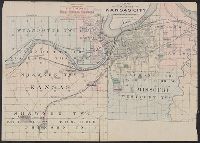
- Found in:
- Beinecke Rare Book and Manuscript Library > Riverview, Wyandott County, Kansas / surveyed April 2nd 1879 by Dan'l OFlaherty, civil eng'r. Kansas City and surroundings / compiled and drawn by D.M. Smith, Wyandott, Kansas ; Ramsey, Millett & Hudson, map engravers, Kns. City Mo.
- Published / Created:
- 188-?]
- Call Number:
- 825 K134 188X
- Container / Volume:
- BRBL_00574
- Image Count:
- 1
- Resource Type:
- Maps, Atlases & Globes
- Found in:
- Beinecke Rare Book and Manuscript Library > Map of the vicinity of Kansas City in Kansas and Missouri / compliments of H.C. Lloyd & Co., real estate brokers and builders ... Kansas City, Mo. ; MacCormac eng. Phila.