Search
You Searched For
Search Results
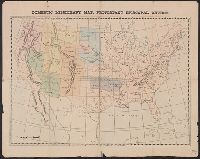
- Published / Created:
- 1874]
- Call Number:
- 75eha 1873
- Image Count:
- 1
- Resource Type:
- Maps, Atlases & Globes
- Subject (Geographic):
- United States--Maps
- Subject (Name):
- States--Maps
- Subject (Topic):
- Missions--United States--Maps
- Found in:
- Beinecke Rare Book and Manuscript Library > Domestic missionary map, Protestant Episcopal Church.
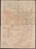
- Published / Created:
- 1918
- Call Number:
- 38 V664 1918
- Container / Volume:
- BRBL_00167
- Image Count:
- 1
- Resource Type:
- Maps, Atlases & Globes
- Subject (Topic):
- histories--United States--Maps
- Found in:
- Beinecke Rare Book and Manuscript Library > Vic-Sur-Aisne [cartographic material].
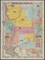
- Creator:
- J.H. Colton & Co
- Published / Created:
- 19--?]
- Call Number:
- 824 1854B
- Container / Volume:
- BRBL_00570
- Image Count:
- 1
- Resource Type:
- Maps, Atlases & Globes
- Description:
- States and "Map of the territory acquired
- Found in:
- Beinecke Rare Book and Manuscript Library > Nebraska and Kansas.
- Creator:
- Blake, Jacob Edmund, 1811 or 12-1846
- Published / Created:
- 1842?]
- Call Number:
- 796fab Sa13 1842D
- Container / Volume:
- BRBL_00530
- Image Count:
- 1
- Resource Type:
- Maps, Atlases & Globes
- Subject (Geographic):
- Texas--Boundaries--United States--Maps
- Found in:
- Beinecke Rare Book and Manuscript Library > Part of the boundary between the United States and Texas, from Sabine River northward to the 36th mile mound / drawn from the notes of survey and copied for the use of the commissioners under the Convention of 25th April 1838, by J. Edm.d Blake 1st Lieut.
- Creator:
- Blake, Jacob Edmund, 1811 or 12-1846
- Published / Created:
- 1842?]
- Call Number:
- 796fab Sa13 1842E
- Container / Volume:
- BRBL_00530
- Image Count:
- 1
- Resource Type:
- Maps, Atlases & Globes
- Subject (Geographic):
- Texas--Boundaries--United States--Maps
- Found in:
- Beinecke Rare Book and Manuscript Library > Part of the boundary between the United States and Texas, north of Sabine River from the 39th [i.e. 36th] to the 72nd mile mound / drawn from the notes of survey and copied for the use of the commissioners under the Convention of 25th April 1838 by J. Edm
- Creator:
- Blake, Jacob Edmund, 1811 or 12-1846
- Published / Created:
- 1842?]
- Call Number:
- 796fab Sa13 1842F
- Container / Volume:
- BRBL_00530
- Image Count:
- 1
- Resource Type:
- Maps, Atlases & Globes
- Subject (Geographic):
- Texas--Boundaries--United States--Maps
- Found in:
- Beinecke Rare Book and Manuscript Library > Part of the boundary between the United States and Texas, north of the Sabine River from the 72nd mile mound to Red River / drawn from the notes of survey and copied for the use of the commissioners under the Convention of 25th April, 1838 by J. Edm.d Bla