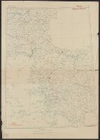
Great Britain. War Office. General Staff. Geographical Section
Published / Created:
1943
Call Number:
11hd 1942D-39
Container / Volume:
BRBL_00010ZD
Image Count:
1
Resource Type:
Maps, Atlases & Globes
Alternative Title:
G.S, G.S. (Series) ; 4249, Geographic Section, General Staff (Series) ; 4249, and Les Pieux-Guernsey
Description:
"50,000/12/43.C.K." printed outside lower left margin. and "French 1:80,000 sheets 16 N.E. S.E.; 27 N.E.; 1:10,560 map of Alderney, 1:21,120 map of Guernsey and part of 1:31,680 map of Jersey."
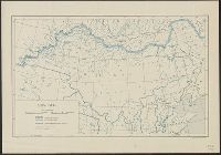
Great Britain. War Office. General Staff. Geographical Section
Published / Created:
1943
Call Number:
11hd 1942D-39
Container / Volume:
BRBL_00010ZD
Image Count:
1
Resource Type:
Maps, Atlases & Globes
Alternative Title:
G.S, G.S. (Series) ; 4249, Geographic Section, General Staff (Series) ; 4249, and Les Pieux-Guernsey
Description:
"50,000/12/43.C.K." print, "French 1:80,000 sheets 16 N.E. S.E.; 27 N.E.; 1:10,560 map of Alderney, 1:21,120 map of Guernsey and part of 1:31,680 map of Jersey.", and Copy 2 Imperfect: Torn, left half of map wanting. Fragment measures 66 x 51 cm.
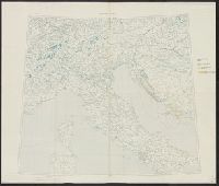
Great Britain. War Office. General Staff. Geographical Section
Published / Created:
1943
Call Number:
11hd 1942D-41
Image Count:
1
Resource Type:
Maps, Atlases & Globes
Alternative Title:
G.S, G.S. (Series) ; 4249, Geographic Section, General Staff (Series) ; 4249, and St. Lo-Vire
Description:
"50,000/1/44 F.C.", "French 1:80,000 sheets 28 S.W., S.E.; 44 N.W., N.E., S.W., S.E.", and Includes glossary, reference table, index to adjoining sheets, incidence of grid letters, and reliability diagram.
Combined map of Istambul and Izmir and part of Sinob and Konia sheets, Europe 1:1,000,000, G.S.G.S. ; 2555, GSGS (Series) ; 2555., International Map Europe 1:1,000,000, and Map No. 2
Description:
"Geographic Section, Peace Congress 103." and Includes index to boundaries and to adjoining sheets.
"Ordnance Survey, December 1918.", Includes index to boundaries and to adjoining sheets., and Ms. notes. Hand col. and pencil marks noting disposition of land areas.
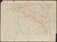
G.S, .G.S ; 3062, GSGS (Series) ; 3062., and St. Julien
Description:
"Ordnance Survey, July 1917.", "Trenches corrected to 30-6-17.", Glossary on verso., Includes index to adjoining sheets., and Relief shown by contours.
Publisher:
Ordnance Survey,
Subject (Geographic):
St. Julien (France)--Maps
Subject (Topic):
World War, 1914-1918--Trench warfare--France--Maps