
You Searched For
1 - 7 of 7
Search Results

1. Cvba.
- Creator:
- Porcacchi, Thomaso, ca. 1530-1585?
- Published / Created:
- 1576]
- Call Number:
- 855 1576A
- Container / Volume:
- BRBL_00695
- Image Count:
- 2
- Resource Type:
- Maps, Atlases & Globes
- Alternative Title:
- Cuba, Descrittione dell' isola Cuba, and Descrittione dell' isola Cvba
- Description:
- Cross Collection no. 275., From author's L'isole piu famose del mondo, 1576., and Relief shown pictorially.
- Publisher:
- Appresso S. Galignani & G. Porro,
- Subject (Geographic):
- Cuba--Maps--Early works to 1800
- Subject (Name):
- Galignani, Simon, printer, Porcacchi, Thomaso, ca. 1530-1585? Isole piu famose del mondo, and Porro, Girolamo, 1520-1604, printer
- Found in:
- Beinecke Rare Book and Manuscript Library > Cvba.
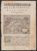
2. Islanda [cartographic material].
- Creator:
- Porcacchi, Thomaso, ca. 1530-1585?
- Published / Created:
- 1576]
- Call Number:
- 343 1576B
- Container / Volume:
- BRBL_00683
- Image Count:
- 2
- Resource Type:
- Maps, Atlases & Globes
- Alternative Title:
- Descrittione dell' isola d'Islanda
- Description:
- A variant printing has caption title: Descrittione dell' isola d'Islanda di Thomaso Porcacchi., From author's L'isole piu famose del mondo, descritte da Thomaso Porcacchi ... Venetia: Appresso S. Galignani & G. Por, and Paginated 1-2, with signature A1 on p. 1.
- Publisher:
- Appresso S. Galignani & G. Porro,
- Subject (Geographic):
- Iceland--Maps--Early works to 1800
- Subject (Name):
- Porcacchi, Thomaso, ca. 1530-1585?. Isole piu famose del mondo
- Found in:
- Beinecke Rare Book and Manuscript Library > Islanda [cartographic material].

3. Prima tavola [Africa].
- Creator:
- Gastaldi, Giacomo, ca. 1500-ca. 1565
- Published / Created:
- 1563]
- Call Number:
- 60 1563
- Container / Volume:
- BRBL_00321
- Image Count:
- 1
- Resource Type:
- Maps, Atlases & Globes
- Alternative Title:
- [Africa] prima tavola
- Description:
- From Ramusio's Navigationi et viaggi. 1563., Has watermark., Includes ill. of ships, sea monsters, etc., Oriented with north to the bottom., Relief shown pictorially., and Sheet measures 31 x 43.5 cm. dgvmp2008.
- Publisher:
- s.n.,
- Subject (Geographic):
- Africa--Maps--Early works to 1800
- Subject (Name):
- Ramusio, Giovanni Battista, 1485-1557. Navigazioni e viaggi
- Found in:
- Beinecke Rare Book and Manuscript Library > Prima tavola [Africa].
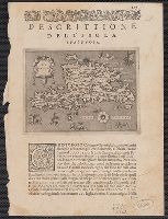
4. Spagnvola.
- Creator:
- Porcacchi, Thomaso, ca. 1530-1585?
- Published / Created:
- 1576]
- Call Number:
- 853 1576A
- Container / Volume:
- BRBL_00694
- Image Count:
- 2
- Resource Type:
- Maps, Atlases & Globes
- Alternative Title:
- Descrittione dell' isola Spagnuola, Descrittione dell' isola Spagnvola, and Spagnuola
- Description:
- From author's L'isole piu famose del mondo, descritte da Thomaso Porcacchi ... Venetia: Appresso S. Galignani & G. Porro, 1576., Paginated 165., and Relief shown pictorially.
- Publisher:
- Appresso S. Galignani & G. Porro,
- Subject (Geographic):
- Hispaniola--Maps--Early works to 1800
- Subject (Name):
- Galignani, Simon, Porcacchi, Thomaso, ca. 1530-1585?. Isole piu famose del mondo, and Porro, Girolamo, 1520-1604
- Found in:
- Beinecke Rare Book and Manuscript Library > Spagnvola.
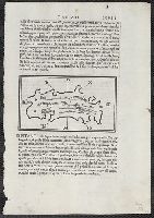
5. [Ciampagu ; Iaua Maggiore, Sondur, and Condur].
- Creator:
- Bordon, Benedetto, 1450-1530
- Published / Created:
- 1528?]
- Call Number:
- 57 1528
- Container / Volume:
- BRBL_00300
- Image Count:
- 2
- Resource Type:
- Maps, Atlases & Globes
- Alternative Title:
- [Iaua Maggiore, Sondur, and Condur].
- Description:
- Appears in Bordon's Libro di Benedetto Bordone nel qual si ragiona de tutte l'isole del mondo. 1528., Ciampagu oriented with north to the right. Iava Maggiore, Sondur, and Condur oriented with north toward the lower right., and Covers Japan, depicted as one isl
- Publisher:
- Nicolo d'Aristotile, detto Zoppino,
- Subject (Geographic):
- Japan--Maps--Early works to 1800 and Java (Indonesia)--Maps--Early works to 1800
- Subject (Name):
- Bordon, Benedetto, 1450-1530. Libro di Benedetto Bordone nel qual si ragiona de tutte l'isole del mondo and Zoppino, Nicolò, fl. 1508-1544
- Found in:
- Beinecke Rare Book and Manuscript Library > [Ciampagu ; Iaua Maggiore, Sondur, and Condur].
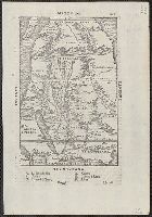
6. [Map of Africa].
- Creator:
- Ramusio, Giovanni Battista, 1485-1557
- Published / Created:
- 155-?]
- Call Number:
- 60 155X
- Container / Volume:
- BRBL_00321
- Image Count:
- 2
- Resource Type:
- Maps, Atlases & Globes
- Description:
- Appears in the author's Delle navigationi et viaggi., Covers Africa, except for the western bulge and southern tip., Has watermark., Includes text on verso., Oriented with north to the bottom., Pg. no. in upper right margin: 261., Relief shown pictorially., and Titl
- Publisher:
- G.B. Ramusio,
- Subject (Geographic):
- Africa--Maps--Early works to 1800
- Subject (Name):
- Ramusio, Giovanni Battista, 1485-1557. Delle navigationi et viaggi
- Found in:
- Beinecke Rare Book and Manuscript Library > [Map of Africa].
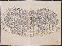
7. [World map].
- Creator:
- Silvani, Bernardo
- Published / Created:
- 1511]
- Call Number:
- 11 1511
- Container / Volume:
- BRBL_00732
- Image Count:
- 2
- Resource Type:
- Maps, Atlases & Globes
- Description:
- Cordiform projection., From Claudii Ptholemaei Alexandrini Liber geographiae cum tabulis ... [Venice : Jacopo Pencio, 1511]., Lanman Collection; dgvmp2008., Left side of the map indicates climates; right side shows zodiacal signs., Map is known as the Bernardus Sylvanus world map., Map is printed in two colors, red and black., Silvani does not show any part of the new world on this map., The verso of the right part of map is showing the western part of the British Isles., and Title supplied by cataloger.
- Publisher:
- Jacopo Pencio,
- Subject (Name):
- Gastaldi, Giacomo, ca. 1500-ca. 1565, Pencio, Jacopo, fl. 1486-1530, and Ptolemy, active 2nd century. Geographia
- Found in:
- Beinecke Rare Book and Manuscript Library > [World map].