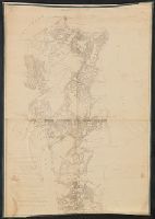
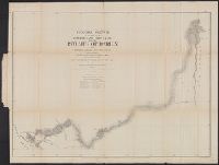
no. 1. Yorktown to Williamsburg -- no. 2. Williamsburg to White House -- no. 3. White House to Harrison's Landing., Relief shown by hachures., and Yale copy: each sheet comprises 4 sections, mounted on linen. "Photographed at the Coast Survey office." Shows no
Publisher:
Corps of Engineers?]
Subject (Geographic):
Virginia Peninsula (Va.)--Maps
Subject (Name):
Dougal, William H., 1822-1895, Humphreys, A. A. (Andrew Atkinson), 1810-1883, Julius Bien & Co, United States Coast Survey., and United States. Army of the Potomac
Subject (Topic):
Peninsular Campaign, 1862--Maps and Williamsburg, Battle of, Williamsburg, Va., 1862--Maps
no. 1. Yorktown to Williamsburg -- no. 2. Williamsburg to White House -- no. 3. White House to Harrison's Landing. and Relief shown by hachures.
Publisher:
Corps of Topographical Engineers?
Subject (Geographic):
Virginia Peninsula (Va.)--Maps
Subject (Name):
Humphreys, A. A. (Andrew Atkinson), 1810-1883, United States. Army of the Potomac, United States. Army. Corps of Topographical Engineers, and Walker, L. E
Blueprint. and Handwritten on original, following author's name: Who has kindly permitted this tracing to be taken for the use of the United States Coast & Geodetic Survey.
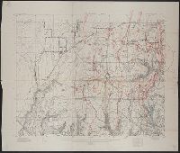
Imperfect. 2 maps (unknown numerations) wanting. Sheet numbered "07-16" has ms. notations., In bottom right margin: Photolith. & printed at U.S. Lake Survey Office, Detroit, Mich., Includes index map., Maps numbered "07-16" and "13-16.", and Relief shown by contours and hachures.
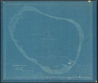
"Constructed, projected and drawn by Fred D. Stuart, hydrographer, late of the U.S. Ex. Ex. ; assisted by Chas. Everett, Jr., draughtsman., "Entered according to act of Congress in the year 1851 by Cadwalader Ringgold ....", and "Executed at the request of the undersigned citizens of the State of California ... and inscribed to William H. Aspinwall, Esq., City of New York."
Publisher:
C.B. Graham?,
Subject (Geographic):
Sacramento River (Calif.)--Maps, San Francisco Bay Area (Calif.)--Maps, and San Joaquin River (Calif.)--Maps
Subject (Name):
Everett, Charles, draughtsman, Graham, C. B. (Curtis B.), and Stuart, Fred D
Subject (Topic):
Nautical charts--California--Sacramento River, Nautical charts--California--San Francisco Bay Area, and Nautical charts--California--San Joaquin River
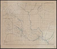
Includes table of "Astronomical determinations" and "Map of Central America showing the routes proposed for an interoceanic ship-canal." and Relief shown by hachures.
Publisher:
s.n.,
Subject (Geographic):
Atrato River Region (Colombia)--Maps and Truandó River Region (Colombia)--Maps
Subject (Name):
United States. Army. Corps of Topographical Engineers
Subject (Topic):
Hydrographic surveying--Colombia--Atrato River Region--Maps and Hydrographic surveying--Colombia--Truandó River Region--Maps