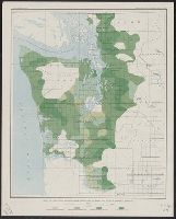
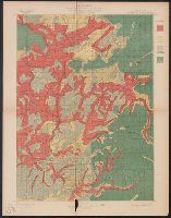
"Julius Bien & Co. Lith. N.Y.", Plate IV from the "Nineteenth annual report" of the U.S. Geological Survey, Part 5, Forest reserves (1898)., and Shows four classes of timber density and public land grid.
Publisher:
The Survey,
Subject (Name):
Geological Survey (U.S.). Annual report
Subject (Topic):
Forests and forestry--Washington (State), Western--Maps
Yosemite Valley, Yosemite National Park, California
Description:
"Surveyed in 1905-1906 in cooperation with the State of California.", At head of title: Department of the Interior., Contour interval 50 feet. Datum is mean sea level., Includes location map and table of "Elevations of principal points.", and Relief shown by contours and spot heights.
Publisher:
U.S. Geological Survey,
Subject (Geographic):
Yosemite Valley (Calif.)--Maps
Subject (Name):
Douglas, Edward Morehouse, 1855-1932, Marshall, R. B. (Robert Bradford), 1867-1949, Matthes, François, 1874-1948, and Urquhart, C. F
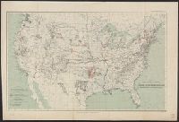
Indian reservations within the limits of the United States
Description:
Insets: Mission Ind. Res. in California. [Scale ca. 1:1,520,640] -- Indian Pueblo grants in New Mexico. [Scale ca. 1:2,534,400] -- Northeastern Oklahoma. [Scale ca. 1:1,520,640].
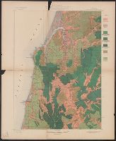
Coos Bay quadrangle, Oregon, land classification and density of standing timber.
Description:
"Julius Bien & Co. Lith. N.Y.", "Surveyed in 1895-96.", Plate CXXVII from the "Twenty-first annual report" of the United States Geological Survey, Part 5, Forest reserves (1900)., Relief shown by contours and spot heights., and Shows seven classes of land cover.
Publisher:
The Survey,
Subject (Geographic):
Coos County (Or.)--Maps
Subject (Name):
Barnard, E. C. (Edward Chester), 1863-1921, Gannett, Henry, 1846-1914, Geological Survey (U.S.). Annual report, and Johnson, A. J
Subject (Topic):
Forests and forestry--Oregon--Coos County--Maps and Land capability for agriculture--Oregon--Coos County--Maps
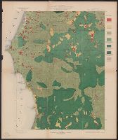
Port Orford quadrangle, Oregon, land classification and density of standing timber.
Description:
"Julius Bien & Co. Lith. N.Y.", "Surveyed in 1897-98.", Plate CXXVI from the "Twenty-first annual report" of the U.S. Geological Survey, Part 5, Forest reserves (1900)., Relief shown by contours and spot heights., and Shows seven classes of land cover.
Publisher:
The Survey,
Subject (Geographic):
Coos County (Or.)--Maps and Curry County (Or.)--Maps
Subject (Name):
Geological Survey (U.S.). Annual report, Johnson, A. J, and Murlin, A. E
Subject (Topic):
Forests and forestry--Oregon--Coos County--Maps, Forests and forestry--Oregon--Curry County--Maps, Land capability for agriculture--Oregon--Coos County--Maps, and Land capability for agriculture--Oregon--Curry County--Maps
Roseburg quadrangle, Oregon, land classification and density of standing timber.
Description:
"Julius Bien & Co. Lith. N.Y.", "Surveyed in 1894-95.", Plate CXXVIII from the "Twenty-first annual report" of the U.S. Geological Survey, Part 5, Forest reserves (1900)., Relief shown by contours and spot heights., and Shows four classes of land cover.
Publisher:
The Survey,
Subject (Geographic):
Douglas County (Or.)--Maps
Subject (Name):
Barnard, E. C. (Edward Chester), 1863-1921, Geological Survey (U.S.). Annual report, and Johnson, A. J
Subject (Topic):
Forests and forestry--Oregon--Douglas County--Maps and Land capability for agriculture--Oregon--Douglas County--Maps
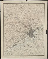
"Henry Gannett, Chief Topographer. H.M. Wilson, Chief Geographer in charge. Triangulation by ... and S.S. Gannett. Topography by Geol. Survey of New Jersey, City of Philadelphia, Frank Sutton ... and Robert Muldrow.", "Surveyed in 1894.", and Relief shown by contours and spot heights.
Publisher:
U.S. Geological Survey,
Subject (Geographic):
Philadelphia Metropolitan Area (Pa.)--Maps
Subject (Name):
Gannett, Henry, 1846-1914, Gannett, Samuel S. (Sameul Stinson), 1861-1939, Geological Survey of New Jersey, Muldrow, Robert, Sutton, Frank, and Wilson, Herbert M. (Herbert Michael), 1860-1920