Skip to search
Skip to main content
Skip to first result
Search
You Searched For
Access
Public
Resource Type
Maps, Atlases & Globes
Creator
Geological Survey (U.S.)
Publication Place
[Washington, D.C.] :
New Search
Search Results
Creator:
Published / Created:
1913
Call Number:
BrSides Double Folio 2019 127
Image Count:
1
Resource Type:
Maps, Atlases & Globes
Alternative Title:
Colorado (Lake County), Leadville mining district
Description:
"Surveyed in 1911.", Includes "Index to shafts" listed alphabetically and by number on map., Map showing responsibility for topography in lower margin., and Relief shown by contours and spot heights.
Publisher:
The Survey,
Subject (Geographic):
Leadville (Colo.)--Maps
Subject (Name):
Davis, E. P., Marshall, R. B. (Robert Bradford), 1867-1949., Robertson, R. B., Semper, C. H., Tatum, Sledge., and Taylor, S. E.
Subject (Topic):
Mines and mineral resources--Colorado--Leadville--Maps.
Found in:
Beinecke Rare Book and Manuscript Library > Leadville mining district [cartographic material] / U.S. Geological Survey ; R.B. Marshall, chief geographer ; Sledge Tatum, geographer in charge ; topography by E.P. Davis and S.E. Taylor ; control by R.B. Robertson, C.H. Semper, and S.E. Taylor.
Creator:
Published / Created:
1909
Call Number:
848 1909
Container / Volume:
BRBL_00630
Image Count:
1
Resource Type:
Maps, Atlases & Globes
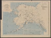
Description:
"Alaska, map A.", Inset: [Aleutian Islands]., and Relief shown by hachures and spot heights.
Publisher:
The Survey,
Subject (Geographic):
Alaska--Maps and Yukon Territory--Maps
Subject (Name):
Brooks, Alfred Hulse, 1871-1924
Found in:
Beinecke Rare Book and Manuscript Library > Map of Alaska / compiled chiefly from maps of the U.S. Geological Survey ... Alfred H. Brooks, geologist in charge, Division of Alaskan Mineral Resources.
Creator:
Published / Created:
1908
Call Number:
848gbc 1908
Container / Volume:
BRBL_00635
Image Count:
1
Resource Type:
Maps, Atlases & Globes
Alternative Title:
Bulletin (United States. Bureau of Mines) ; 36. and Bureau of Mines Bulletin ; no. 36
Description:
In upper margin: "Bureau of Mines, Bulletin no. 36, Plate I." and Includes 1 inset map: Aleutian Islands.
Publisher:
Geological Survey,
Subject (Geographic):
Alaska--Maps
Subject (Name):
Brooks, Alfred H. (Alfred Hulse), 1871-1924
Subject (Topic):
Mines and mineral resources--Alaska--Maps
Found in:
Beinecke Rare Book and Manuscript Library > Map of Alaska showing the known distribution of mineral resources / U.S. Geological Survey, compiled under the direction of Alfred H. Brooks, Geologist in charge of Division of Alaskan Mineral Resources, U.S. Geological Survey.
Creator:
Published / Created:
1893
Call Number:
766 1893
Container / Volume:
BRBL_00467
Image Count:
4
Resource Type:
Maps, Atlases & Globes
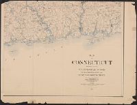
Description:
Contour interval 100 feet. and Datum is mean sea level.
Publisher:
US Geological Survey,
Subject (Geographic):
Connecticut--Maps
Found in:
Beinecke Rare Book and Manuscript Library > Map of Connecticut / prepared by the U.S. Geological Survey in co-operation with the State of Connecticut.
Creator:
Published / Created:
1893 (1899 printing)
Call Number:
766 1893C
Container / Volume:
BRBL_00467
Image Count:
2
Resource Type:
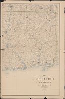
Maps, Atlases & Globes
Description:
"Reprinted Sept. 1899.", Contour interval 100 feet., and Datum is mean sea level.
Publisher:
US Geological Survey,
Subject (Geographic):
Connecticut--Maps
Found in:
Beinecke Rare Book and Manuscript Library > Map of Connecticut / prepared by the U.S. Geological Survey in co-operation with the State of Connecticut.
Creator:
Published / Created:
1893 (1899 printing)
Call Number:
766 1893C
Container / Volume:
BRBL_00467
Image Count:
3
Resource Type:
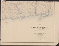
Maps, Atlases & Globes
Description:
"Reprinted Sept. 1899.", Contour interval 100 feet., Copy 1: Imperfect: eastern sheet wanting upper half., and Datum is mean sea level.
Publisher:
US Geological Survey,
Subject (Geographic):
Connecticut--Maps
Found in:
Beinecke Rare Book and Manuscript Library > Map of Connecticut / prepared by the U.S. Geological Survey in co-operation with the State of Connecticut.
Creator:
Published / Created:
1912
Call Number:
71 1912
Container / Volume:
BRBL_00371
Image Count:
1
Resource Type:
Maps, Atlases & Globes
Description:
Includes inset of Aleutian Islands and Windward Islands. and Shows drainage features.
Publisher:
Engraved and printed by the U.S. Geological Survey,
Subject (Geographic):
North America--Maps
Found in:
Beinecke Rare Book and Manuscript Library > Map of North America : reduced from map on scale of 1:5,000,000 / compiled by the U.S. Geological Survey.
Creator:
Published / Created:
1915
Call Number:
766C Sa99 1915
Container / Volume:
BRBL_00474
Image Count:
1
Resource Type:
Maps, Atlases & Globes
Alternative Title:
Water-Supply Paper 374
Description:
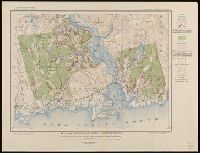
From Water-Supply Paper 374, plate 13. and Relief shown by contours.
Publisher:
U.S. Geological Survey,
Subject (Geographic):
Saybrook (Conn.)--Maps
Subject (Topic):
Groundwater--Connecticut--Saybrook--Maps and Water-supply--Connecticut--Saybrook--Maps
Found in:
Beinecke Rare Book and Manuscript Library > Map of Saybrook area, Connecticut, showing rock outcrops, wooded areas, and ground-water conditions.
Creator:
Published / Created:
[1898].
Call Number:
847gc 1898
Container / Volume:
BRBL_00628
Image Count:
1
Resource Type:
Maps, Atlases & Globes
Description:
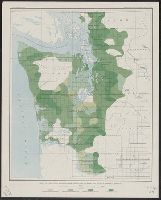
"Julius Bien & Co. Lith. N.Y.", Plate IV from the "Nineteenth annual report" of the U.S. Geological Survey, Part 5, Forest reserves (1898)., and Shows four classes of timber density and public land grid.
Publisher:
The Survey,
Subject (Name):
Geological Survey (U.S.). Annual report
Subject (Topic):
Forests and forestry--Washington (State), Western--Maps
Found in:
Beinecke Rare Book and Manuscript Library > Map of Western Washington showing density of merchantable timber / U.S. Geological Survey.
Creator:
Published / Created:
[1918]
Call Number:
844fcm Y83 1918
Container / Volume:
BRBL_00615
Image Count:
1
Resource Type:
Maps, Atlases & Globes
Alternative Title:
Yosemite Valley, Yosemite National Park, California
Description:
"Surveyed in 1905-1906 in cooperation with the State of California.", At head of title: Department of the Interior., Contour interval 50 feet. Datum is mean sea level., Includes location map and table of "Elevations of principal points.", and Relief shown by contours and spot heights.
Publisher:
U.S. Geological Survey,
Subject (Geographic):
Yosemite Valley (Calif.)--Maps
Subject (Name):
Douglas, Edward Morehouse, 1855-1932, Marshall, R. B. (Robert Bradford), 1867-1949, Matthes, François, 1874-1948, and Urquhart, C. F
Found in:
Beinecke Rare Book and Manuscript Library > Map of Yosemite Valley, Yosemite National Park, California, Mariposa County / U.S. Geological Survey ; State of California ; E.M. Douglas, geographer ; R.B. Marshall, in charge of section ; topography by F.E. Matthes ; triangulation by C.F. Urquhart.
Branch:v1.61.8 ,Deployed:2024-06-20T11:15:04-04:00