Search
You Searched For
Search Results
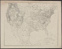
- Creator:
- U.S. Coast and Geodetic Survey
- Published / Created:
- 1880
- Call Number:
- 75AK 1880
- Container / Volume:
- BRBL_00407A
- Image Count:
- 1
- Resource Type:
- Maps, Atlases & Globes
- Found in:
- Beinecke Rare Book and Manuscript Library > Base-map of the United States / Drawn and engraved by A. and H. Lindenkohl.
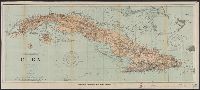
- Creator:
- U.S. Coast and Geodetic Survey
- Published / Created:
- 1898
- Call Number:
- 855hc 1898Q
- Container / Volume:
- BRBL_00765
- Image Count:
- 1
- Resource Type:
- Maps, Atlases & Globes
- Found in:
- Beinecke Rare Book and Manuscript Library > Cuba : part of chart "E" / Treasury Department, U.S. Coast and Geodetic Survey, Henry S. Pritchett, Superintendent.
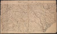
- Creator:
- U.S. Coast and Geodetic Survey
- Published / Created:
- [1861?]
- Call Number:
- 754 1861C
- Container / Volume:
- BRBL_00416
- Image Count:
- 1
- Resource Type:
- Maps, Atlases & Globes
- Found in:
- Beinecke Rare Book and Manuscript Library > Middle Georgia & South Carolina.
- Creator:
- U.S. Coast and Geodetic Survey
- Published / Created:
- 1883
- Call Number:
- 771 W528 1883
- Container / Volume:
- BRBL_00492
- Image Count:
- 1
- Resource Type:
- Maps, Atlases & Globes
- Found in:
- Beinecke Rare Book and Manuscript Library > West Point, New York / from a Plane Table survey under the direction of H.L. Whiting, Assistant, by W.C. Hodgkins, Aid. ; engraved from the original sheet by H.C. Evans ; title and lettering by E.A. Maedel.