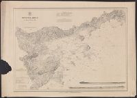
"No. 20"--Upper right margin., "The Yukon River, ranges of mountains, shores of Norton Sound and many features of the interior from a reconnaissance by W.H. Dall, Director of the Scientific Corps, of the W.U. Tel. Expedition, 1865-1868.", and Inset: Aleutian Islands.
Publisher:
U.S. Coast Survey,
Subject (Geographic):
Alaska--Maps and Yukon Territory--Maps
Subject (Name):
Dall, William Healey, 1845-1927 and Lindenkohl, H. (Henry)
"Electrotype Copy No. 7 U.S.C.S.", "Issued December 187, "Redd. Drng. by C. Mahon & G. Farquahar.", and Includes inset horizontal views: Entrance to Salem by main channel, Baker's Island Lights ... -- Entrance to Salem by Cat Island channel, Marblehead Light ...
Publisher:
The Survey,
Subject (Geographic):
Salem Region (Mass.)--Maps
Subject (Name):
Bradford, J. S, Dankworth, Frederick, b. ca. 1804, Hilgard, J. E. (Julius Erasmus), 1825-1891, McBlair, C. H, McCoy, G, Temple, W. G, and Whiting, Henry L
Subject (Topic):
Harbors--Massachusetts--Salem--Maps and Nautical charts--Massachusetts--Salem Region
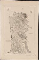
"Electrotype copy no. 1, U.S.C.S.", "Note: This map is reduced from surveys made ... between 1850 and '57 ... and from supplementary surveys of the interior made ... in 1867 and '68 ... The scale of the original maps is 1:10,000.", "Plate no. 1179.", and Contour interval 20 ft.
Publisher:
The Survey,
Subject (Geographic):
San Francisco (Calif.)--Maps and San Francisco Peninsula (Calif.)--Maps
Subject (Name):
Davidson, George, 1825-1911 and U.S. Coast and Geodetic Survey
"Note: This map is reduced from surveys made ... between 1850 and '57 ... and from supplementary surveys of the interior made ... in 1867 and '68 ... The scale of the original maps is 1:10,000.", Contour interval 20 ft., and Library's copy annotated in ink and pencil to show geological information.
Publisher:
The Survey,
Subject (Geographic):
San Francisco (Calif.)--Maps and San Francisco Peninsula (Calif.)--Maps
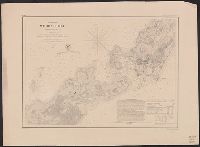
"Engd. by A. Petersen & E.A. Maedel" lower right and MUDDGDC T 11.1:857/(I).8: "No.10" printed outside upper left margin. "Transferred & printed by Lang & Lang, Lith. 66 Fulton St., N.Y." printed outside upper right margin; otherwise identical to 764cea 1857.
Publisher:
U.S. Coast Survey,
Subject (Geographic):
Woods Hole (Mass.)--Maps
Subject (Topic):
Harbors--Massachusetts--Woods Hole--Maps and Nautical charts--Massachusetts--Woods Hole