Skip to search
Skip to main content
Skip to first result
Search
You Searched For
Extent of Digitization
Completely digitized
Repository
Beinecke Rare Book and Manuscript Library
Genre
Maps
Publication Place
[Washington, D.C.] :
New Search
Search Results
Creator:
Published / Created:
1899
Call Number:
60fab 1899
Container / Volume:
BRBL_00329
Image Count:
1
Resource Type:
Maps, Atlases & Globes
Publisher:
U.S. Treasury Department,
Subject (Geographic):
Africa--Maps
Found in:
Beinecke Rare Book and Manuscript Library > Africa, its political divisions and commercial routes / Norris Peters Co., photo-litho., Washington, D.C.
Creator:
Published / Created:
1869
Call Number:
848 1869
Container / Volume:
BRBL_00630
Image Count:
1
Resource Type:
Maps, Atlases & Globes
Description:
"No. 20"--Upper right margin., "The Yukon River, ranges of mountains, shores of Norton Sound and many features of the interior from a reconnaissance by W.H. Dall, Director of the Scientific Corps, of the W.U. Tel. Expedition, 1865-1868.", and Inset: Aleutian Islands.
Publisher:
U.S. Coast Survey,
Subject (Geographic):
Alaska--Maps and Yukon Territory--Maps
Subject (Name):
Dall, William Healey, 1845-1927 and Lindenkohl, H. (Henry)
Found in:
Beinecke Rare Book and Manuscript Library > Alaska and adjoining territory / drawn by H. Lindenkohl.
Creator:
Published / Created:
1906
Call Number:
771cbf Al13 1906
Image Count:
1
Resource Type:
Maps, Atlases & Globes
Description:
"Henry Gannet, Chief Geographer, H.M. Wilson, Geographer in charge; Topography by Frank Sutton and J.H. Jennings; surveyed in 1891-1892.", "Reprinted Nov. 1906.", "Surveyed in cooperation with the State of New York.", Contour interval 20 feet., and Relief shown by contours.
Publisher:
U.S. Geological Survey,
Subject (Geographic):
Albany Region (N.Y.)--Maps
Subject (Name):
Gannett, Henry, 1846-1914
Found in:
Beinecke Rare Book and Manuscript Library > Albany and vicinity, New York.
Creator:
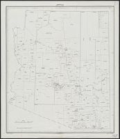
Published / Created:
1934
Call Number:
842fb 1930
Container / Volume:
BRBL_00600
Image Count:
1
Resource Type:
Maps, Atlases & Globes
Publisher:
Bureau of the Census,
Subject (Geographic):
Arizona--Administrative and political divisions--Maps
Found in:
Beinecke Rare Book and Manuscript Library > Arizona : minor civil divisions / Department of Commerce, Bureau of the Census, 1930.
Creator:
Published / Created:
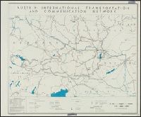
1945
Call Number:
42gm 1945
Container / Volume:
BRBL_00245
Image Count:
1
Resource Type:
Maps, Atlases & Globes
Description:
"Data as of 1938 with some additions to 1944." and "No. 5394."
Publisher:
Reproduction Branch, OSS,
Subject (Geographic):
Austria--Maps
Subject (Topic):
Electric power transmission--Austria--Maps, Telecommunication--Austria--Maps, and Transportation--Austria--Maps
Found in:
Beinecke Rare Book and Manuscript Library > Austria: international transportation and communication network [cartographic material] / R & A, OSS.
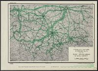
Creator:
Published / Created:
1944
Call Number:
36gme 1944A
Container / Volume:
BRBL_00132
Image Count:
1
Resource Type:
Maps, Atlases & Globes
Description:
"No. A-3051, 30 Jan. 1944." and Relief shown by spot heights.
Publisher:
lithographed in the Reproduction Branch, OSS,
Subject (Topic):
Railroads--Germany--Maps
Found in:
Beinecke Rare Book and Manuscript Library > Average daily movement of passenger trains on the German National Railroad of central Germany.
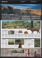
Creator:
Published / Created:
[2001]
Call Number:
823 B14 2001
Container / Volume:
BRBL_00568
Image Count:
2
Resource Type:
Maps, Atlases & Globes
Alternative Title:
Badlands and Badlands, official map and guide
Description:
"*GPO: 2001--472-470/00404. Reprint 2001.", Includes text, area map, and map of the Cedar Pass area., Relief shown by shading., and Text and col. ill. on verso.
Publisher:
The Service,
Subject (Geographic):
Badlands National Park (S.D.)--Maps
Found in:
Beinecke Rare Book and Manuscript Library > Badlands National Park, South Dakota / National Park Service, U.S. Department of the Interior.
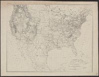
Creator:
Published / Created:
1880
Call Number:
75AK 1880
Container / Volume:
BRBL_00407A
Image Count:
1
Resource Type:
Maps, Atlases & Globes
Publisher:
U.S. Coast and Geodetic Survey,
Subject (Geographic):
United States--Maps
Found in:
Beinecke Rare Book and Manuscript Library > Base-map of the United States / Drawn and engraved by A. and H. Lindenkohl.
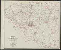
Creator:
Published / Created:
1943
Call Number:
335gme 1943
Container / Volume:
BRBL_00087
Image Count:
1
Resource Type:
Maps, Atlases & Globes
Description:
In lower left margin: Map No. 2168, 3 March 1943. and Shows 6 different categories of rail lines.
Publisher:
O.S.S. Repro. Section,
Subject (Topic):
Railroads--Belgium--Maps
Found in:
Beinecke Rare Book and Manuscript Library > Belgium, railroads / compiled and drawn in the Branch of Research and Analysis, OSS.
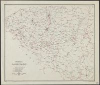
Branch:v1.61.8 ,Deployed:2024-06-20T11:15:15-04:00