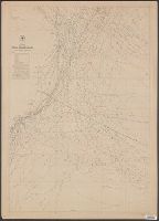
[Maury map collection ; ser. A2], Maury's wind & current chart, S. Atlantic, Maury's wind & current chart, South Atlantic, Maury's wind and current chart, series A, South Atlantic, Maury's wind and current chart, South Atlantic, and South Atlantic
Description:
"Series A.", Copy imperfect: All sheets torn and repaired along, Does not cover the southeastern Atlantic south of latitude 40° S., Includes notes., Shows prevailing wind direction by month., and Various eds. of some sheets with updated and additional information.
Publisher:
United States Hydrographical Office,
Subject (Geographic):
South Atlantic Ocean--Charts, diagrams, etc
Subject (Name):
Flye, Wm, Maury, Matthew Fontaine, 1806-1873. Wind and current charts, Sherman & Smith, Temple, William G. (William Grenville), 1824-1894, United States Naval Observatory, United States. Bureau of Ordnance and Hydrography, and United States. Hydrographic Office
[Maury map collection ; ser. A2], Maury's wind & current chart, S. Atlantic, Maury's wind & current chart, South Atlantic, Maury's wind and current chart, series A, South Atlantic, Maury's wind and current chart, South Atlantic, and South Atlantic
Description:
"Series A.", DLC, Includes notes., Sheet 1 (1853) -- Sheet 2 (no date) -- Sheet 3 (no date) -- Sheet 3 (Updated) -- Sheet 4 (no date), 2 copies., Sheets individually numbered, e.g.: Series A. No. 1., and Various eds. of some sheets with updated and additional info
Publisher:
United States Hydrographical Office,
Subject (Geographic):
South Atlantic Ocean--Charts, diagrams, etc
Subject (Name):
Flye, Wm, Maury, Matthew Fontaine, 1806-1873. Wind and current charts, Sherman & Smith, Temple, William G. (William Grenville), 1824-1894, United States Naval Observatory, United States. Bureau of Ordnance and Hydrography, and United States. Hydrographic Office
[Maury map collection ; ser. A2], Maury's wind & current chart, S. Atlantic, Maury's wind & current chart, South Atlantic, Maury's wind and current chart, series A, South Atlantic, Maury's wind and current chart, South Atlantic, and South Atlantic
Description:
"Series A.", Copy imperfect: All sheets torn and repaired along fold-line. Sheet 3 liquid staining, minor losses along edges and discoloration throughout, mounted on cloth backing., Does not cover the southeastern Atlantic south of latitude 40° S., and Originall
Publisher:
United States Hydrographical Office,
Subject (Geographic):
South Atlantic Ocean--Charts, diagrams, etc
Subject (Name):
Flye, Wm, Maury, Matthew Fontaine, 1806-1873. Wind and current charts, Sherman & Smith, Temple, William G. (William Grenville), 1824-1894, United States Naval Observatory, United States. Bureau of Ordnance and Hydrography, and United States. Hydrographic Office