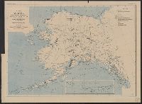
"No. 20"--Upper right margin., "The Yukon River, ranges of mountains, shores of Norton Sound and many features of the interior from a reconnaissance by W.H. Dall, Director of the Scientific Corps, of the W.U. Tel. Expedition, 1865-1868.", and Inset: Aleutian Islands.
Publisher:
U.S. Coast Survey,
Subject (Geographic):
Alaska--Maps and Yukon Territory--Maps
Subject (Name):
Dall, William Healey, 1845-1927 and Lindenkohl, H. (Henry)
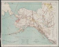
At head of title: Department of the Interior, General Land Office, Hon. Binger Hermann, Commissioner., Includes distance table and inset maps of "From Juneau to Forty Mile Creek" and the Aleutian Islands., Relief shown by shading and spot heights., and Shows land offices and reservations, transportation routes, mineral deposits, reported gold regions, isothermal lines, and religious missions by denomination.
Publisher:
General Land Office,
Subject (Geographic):
Alaska--Maps
Subject (Name):
Norris Peters Co and United States. General Land Office
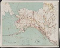