United States. Office of Strategic Services. Research and Analysis Branch
Published / Created:
1945
Call Number:
56gm 1945C
Container / Volume:
BRBL_00298
Image Count:
1
Resource Type:
Maps, Atlases & Globes
Description:
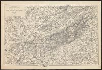
"No. 3294.", Includes reliability diagram., Inset maps: Routes to northwest China through Russia and India. -- [Area map]., and Relief shown by spot heights.
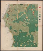
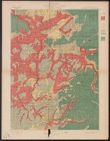
Coos Bay quadrangle, Oregon, land classification and density of standing timber.
Description:
"Julius Bien & Co. Lith. N.Y.", "Surveyed in 1895-96.", Plate CXXVII from the "Twenty-first annual report" of the United States Geological Survey, Part 5, Forest reserves (1900)., Relief shown by contours and spot heights., and Shows seven classes of land cover.
Publisher:
The Survey,
Subject (Geographic):
Coos County (Or.)--Maps
Subject (Name):
Barnard, E. C. (Edward Chester), 1863-1921, Gannett, Henry, 1846-1914, Geological Survey (U.S.). Annual report, and Johnson, A. J
Subject (Topic):
Forests and forestry--Oregon--Coos County--Maps and Land capability for agriculture--Oregon--Coos County--Maps
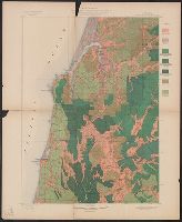
Port Orford quadrangle, Oregon, land classification and density of standing timber.
Description:
"Julius Bien & Co. Lith. N.Y.", "Surveyed in 1897-98.", Plate CXXVI from the "Twenty-first annual report" of the U.S. Geological Survey, Part 5, Forest reserves (1900)., Relief shown by contours and spot heights., and Shows seven classes of land cover.
Publisher:
The Survey,
Subject (Geographic):
Coos County (Or.)--Maps and Curry County (Or.)--Maps
Subject (Name):
Geological Survey (U.S.). Annual report, Johnson, A. J, and Murlin, A. E
Subject (Topic):
Forests and forestry--Oregon--Coos County--Maps, Forests and forestry--Oregon--Curry County--Maps, Land capability for agriculture--Oregon--Coos County--Maps, and Land capability for agriculture--Oregon--Curry County--Maps
Roseburg quadrangle, Oregon, land classification and density of standing timber.
Description:
"Julius Bien & Co. Lith. N.Y.", "Surveyed in 1894-95.", Plate CXXVIII from the "Twenty-first annual report" of the U.S. Geological Survey, Part 5, Forest reserves (1900)., Relief shown by contours and spot heights., and Shows four classes of land cover.
Publisher:
The Survey,
Subject (Geographic):
Douglas County (Or.)--Maps
Subject (Name):
Barnard, E. C. (Edward Chester), 1863-1921, Geological Survey (U.S.). Annual report, and Johnson, A. J
Subject (Topic):
Forests and forestry--Oregon--Douglas County--Maps and Land capability for agriculture--Oregon--Douglas County--Maps