Search
You Searched For
Search Results
- Creator:
- Geological Survey (U.S.)
- Published / Created:
- [1900].
- Call Number:
- 847gc M865 1897
- Container / Volume:
- BRBL_00628
- Image Count:
- 1
- Resource Type:
- Maps, Atlases & Globes
- Found in:
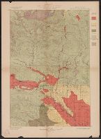
- Beinecke Rare Book and Manuscript Library > Washington, Mount Stuart quadrangle : land classification and density of standing timber / U.S. Geological Survey ; R.U. Goode, geographer in charge ; triangulation by S.S. Gannett ; topography by G.E. Hyde ; Henry Gannett, geographer in charge ; land cla
- Creator:
- Geological Survey (U.S.)
- Published / Created:
- [1901]
- Call Number:
- 847gc Sp65 1898
- Container / Volume:
- BRBL_00628
- Image Count:
- 1
- Resource Type:
- Maps, Atlases & Globes
- Found in:
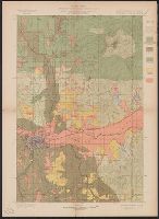
- Beinecke Rare Book and Manuscript Library > Washington-Idaho, Spokane quadrangle : land classification and density of standing timber / U.S. Geological Survey ; R.U. Goode, geographer in charge ; triangulation by S.S. Gannett ; topography by Van H. Manning ; Henry Gannett, geographer in charge ; la
- Creator:
- United States. Office of Strategic Services. Research and Analysis Branch
- Published / Created:
- 1943
- Call Number:
- 654gcr 1943
- Container / Volume:
- BRBL_00344
- Image Count:
- 1
- Resource Type:
- Maps, Atlases & Globes
- Found in:
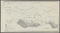
- Beinecke Rare Book and Manuscript Library > West Africa, forest zones / drawn in R and A, OSS.
- Creator:
- U.S. Coast and Geodetic Survey
- Published / Created:
- 1883
- Call Number:
- 771 W528 1883
- Container / Volume:
- BRBL_00492
- Image Count:
- 1
- Resource Type:
- Maps, Atlases & Globes
- Found in:
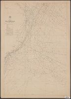
- Beinecke Rare Book and Manuscript Library > West Point, New York / from a Plane Table survey under the direction of H.L. Whiting, Assistant, by W.C. Hodgkins, Aid. ; engraved from the original sheet by H.C. Evans ; title and lettering by E.A. Maedel.
- Creator:
- Maury, Matthew Fontaine, 1806-1873
- Published / Created:
- [1847?]-1853.
- Call Number:
- 11cfk 1850A-3
- Container / Volume:
- BRBL_00768
- Image Count:
- 4
- Resource Type:
- Maps, Atlases & Globes
- Found in:
- Beinecke Rare Book and Manuscript Library > Wind and current chart of the South Atlantic [cartographic material] / by M.F. Maury, L.L.D.U.S. Navy, Superindt. of U.S.N. Observatory ; compiled from materials in the Bureau of Ordnance and Hydrography, Commodore Charles Morris, Chief of Bureau.
- Creator:
- Maury, Matthew Fontaine, 1806-1873
- Published / Created:
- [1847?]-1853.
- Call Number:
- 11cfk 1850A-3
- Container / Volume:
- BRBL_00768
- Image Count:
- 1
- Resource Type:
- Maps, Atlases & Globes
- Found in:
- Beinecke Rare Book and Manuscript Library > Wind and current chart of the South Atlantic [cartographic material] / by M.F. Maury, L.L.D.U.S. Navy, Superindt. of U.S.N. Observatory ; compiled from materials in the Bureau of Ordnance and Hydrography, Commodore Charles Morris, Chief of Bureau.
- Creator:
- Geological Survey (U.S.)
- Published / Created:
- [1900].
- Call Number:
- 833gc B19 1898
- Container / Volume:
- BRBL_00586
- Image Count:
- 1
- Resource Type:
- Maps, Atlases & Globes
- Found in:
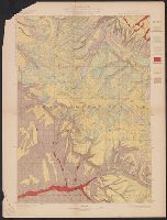
- Beinecke Rare Book and Manuscript Library > Wyoming, Bald Mountain quadrangle : land classification and density of standing timber / U.S. Geological Survey ; E.M. Douglas, geographer in charge ; triangulation by W.S. Post ; topography by Frank Tweedy ; Henry Gannett, geographer in charge ; land cla
- Creator:
- Geological Survey (U.S.)
- Published / Created:
- [1900].
- Call Number:
- 833gc C625 1899
- Container / Volume:
- BRBL_00586
- Image Count:
- 1
- Resource Type:
- Maps, Atlases & Globes
- Found in:
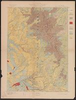
- Beinecke Rare Book and Manuscript Library > Wyoming, Cloud Peak quadrangle : land classification and density of standing timber / U.S. Geological Survey ; E.M. Douglas, geographer in charge ; triangulation by T.M. Bannon ; topography by H.S. Wallace and F.E. Matthes ; Henry Gannett, geographer in c
- Creator:
- Geological Survey (U.S.)
- Published / Created:
- [1900].
- Call Number:
- 833gc D337 1899
- Container / Volume:
- BRBL_00586
- Image Count:
- 1
- Resource Type:
- Maps, Atlases & Globes
- Found in:
- Beinecke Rare Book and Manuscript Library > Wyoming, Dayton quadrangle : land classification and density of standing timber / U.S. Geological Survey ; E.M. Douglas, geographer in charge ; triangulation by W.S. Post ; topography by Frank Tweedy ; Henry Gannett, geographer in charge ; land classifica