Search
You Searched For
Search Results
- Creator:
- United States. General Land Office
- Call Number:
- 833 1879
- Container / Volume:
- BRBL_00584
- Image Count:
- 1
- Resource Type:
- Maps, Atlases & Globes
- Found in:
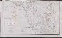
- Beinecke Rare Book and Manuscript Library > Territory of Wyoming : 1879 / compiled from the official records of the General Land Office and other sources by C. Roeser, Principal Draughtsman, G.L.O.
- Published / Created:
- .
- Call Number:
- 75H 1895
- Container / Volume:
- BRBL_00414A
- Image Count:
- 1
- Resource Type:
- Maps, Atlases & Globes
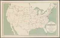
- Found in:
- Beinecke Rare Book and Manuscript Library > Map of the United States showing Military Posts and Principal Lines of Communication / Prepared by direction of the Secretary of War in the Office of the Chief of Engineers U.S.A.
- Creator:
- United States. Army. Corps of Engineers, author
- Published / Created:
- [1834]
- Call Number:
- 761 1834
- Container / Volume:
- BRBL_00447
- Image Count:
- 1
- Resource Type:
- Maps, Atlases & Globes
- Found in:
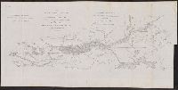
- Beinecke Rare Book and Manuscript Library > The Kennebec River and adjacent country : shewing the routes examined for a road from Augusta to the Canada line in the direction of Quebec / reconnaissance made in 1834 by Hartman Bache, T.E. & B.T. Major, assisted by G.W. Ward, 2nd Lt. 2nd Arty. and J.F
- Creator:
- Gallatin, Albert, 1761-1849
- Published / Created:
- [1836]
- Call Number:
- 71ed 1836
- Container / Volume:
- BRBL_00371
- Image Count:
- 1
- Resource Type:
- Maps, Atlases & Globes
- Found in:
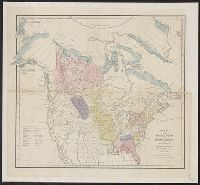
- Beinecke Rare Book and Manuscript Library > Map of the Indian tribes of North America, about 1600 A.D. along the Atlantic, & about 1800 A.D. westwardly / published by the Amer. Antiq. Soc. from a drawing by Hon. A. Gallatin.
- Creator:
- Graham, J. D. (James Duncan), 1799-1865
- Published / Created:
- 1836
- Call Number:
- 764 C172 1836
- Container / Volume:
- BRBL_00456A
- Image Count:
- 4
- Resource Type:
- Maps, Atlases & Globes
- Found in:
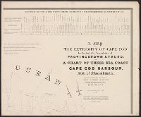
- Beinecke Rare Book and Manuscript Library > A map of the extremity of Cape Cod : including the townships of Provincetown & Truro, with a chart of their sea coast and of Cape Cod Harbour, State of Massachusetts / executed under the direction of Major J.D. Graham ... 1833, '34, & '35.
- Published / Created:
- [1843]
- Call Number:
- 807 1843
- Container / Volume:
- BRBL_00731
- Image Count:
- 2
- Resource Type:
- Maps, Atlases & Globes
- Found in:
- Beinecke Rare Book and Manuscript Library > Hydrographical basin of the upper Mississippi River ... / by J.N. Nicollet ...
- Creator:
- Maury, Matthew Fontaine, 1806-1873
- Published / Created:
- [1847?]-1853.
- Call Number:
- 11cfk 1850A-3
- Container / Volume:
- BRBL_00768
- Image Count:
- 1
- Resource Type:
- Maps, Atlases & Globes
- Found in:
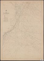
- Beinecke Rare Book and Manuscript Library > Wind and current chart of the South Atlantic [cartographic material] / by M.F. Maury, L.L.D.U.S. Navy, Superindt. of U.S.N. Observatory ; compiled from materials in the Bureau of Ordnance and Hydrography, Commodore Charles Morris, Chief of Bureau.
- Creator:
- Maury, Matthew Fontaine, 1806-1873
- Published / Created:
- [1847?]-1853.
- Call Number:
- 11cfk 1850A-3
- Container / Volume:
- BRBL_00768
- Image Count:
- 1
- Resource Type:
- Maps, Atlases & Globes
- Found in:
- Beinecke Rare Book and Manuscript Library > Wind and current chart of the South Atlantic [cartographic material] / by M.F. Maury, L.L.D.U.S. Navy, Superindt. of U.S.N. Observatory ; compiled from materials in the Bureau of Ordnance and Hydrography, Commodore Charles Morris, Chief of Bureau.
- Creator:
- Maury, Matthew Fontaine, 1806-1873
- Published / Created:
- [1847?]-1853.
- Call Number:
- 11cfk 1850A-3
- Container / Volume:
- BRBL_00768
- Image Count:
- 4
- Resource Type:
- Maps, Atlases & Globes
- Found in:
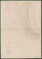
- Beinecke Rare Book and Manuscript Library > Wind and current chart of the South Atlantic [cartographic material] / by M.F. Maury, L.L.D.U.S. Navy, Superindt. of U.S.N. Observatory ; compiled from materials in the Bureau of Ordnance and Hydrography, Commodore Charles Morris, Chief of Bureau.
- Creator:
- Maury, Matthew Fontaine, 1806-1873
- Published / Created:
- 1852-[1859?]
- Call Number:
- 11cfk 1850A-2
- Container / Volume:
- BRBL_00767
- Image Count:
- 1
- Resource Type:
- Maps, Atlases & Globes
- Found in:
- Beinecke Rare Book and Manuscript Library > Maury's wind and current chart [cartographic material] : South Pacific / drawn by Lardner Gibbon, P.M. U.S.N.