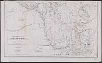
Outline map of the United States and Middle America showing proposed routes of the Pacific Rail Road and its branches in connection with the various systems of existing and unfinished rail roads from the Mississippi Valley to the Atlantic and Gulf coasts.
Description:
A table of distances appears to the right of the map., Designed to accompany Senator William Gwin's Congressional Bill of 1852., and Lithograph, printed in black with rail routes in red.
Publisher:
General Land Office,
Subject (Name):
Pacific Railroad and United States. General Land Office
Subject (Topic):
Railroads--North America--Maps and Railroads--United States--Maps
"Engd. by A. Petersen & E.A. Maedel" lower right and MUDDGDC T 11.1:857/(I).8: "No.10" printed outside upper left margin. "Transferred & printed by Lang & Lang, Lith. 66 Fulton St., N.Y." printed outside upper right margin; otherwise identical to 764cea 1857.
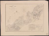
Publisher:
U.S. Coast Survey,
Subject (Geographic):
Woods Hole (Mass.)--Maps
Subject (Topic):
Harbors--Massachusetts--Woods Hole--Maps and Nautical charts--Massachusetts--Woods Hole